Heading To Black Mesa
After spending most of the previous week in Taos, we made a stop in Kenton to summit Oklahoma's state highpoint. We spent the previous night in a very small town called Clayton. The hotel was nice enough and the folks were all very friendly. We hunted every geocache located in that town (all 4 of them) and then hit the sack by 10. After taking the wrong turn to get out of town, we were finally on the way to Kenton by 5:30 am. It was about a 45 minute drive or so, passing through a few open ranges. The cows were grazing right next to the highway, so we had to take it slow and toot the horn a few times. The sunrise that morning was awesome, to say the least.
Trailhead
The trailhead was very easy to find, especially since we could see the mesa from pretty far off. We took the first left turn after passing through the tiny town of Kenton. (The road to the trailhead is east of Kenton) It's about a 5 mile drive from there, passing through another open range with cows and horses. The horses were on the road.
The trailhead has a nice sized gravel parking lot with an information board just inside the gate. It states that the trail is 4.2 miles one way and that you can expect it to take you 4 or 5 hours to complete; if you are a fast hiker, maybe 3.5 hours. By the time we filled our camelbaks and hit the trial it was 7:00 and chilly.
To The Hill
We were only about 1.5 miles into the hike when we had to shed our jackets. Rather than carry them, we hid them in a tree and marked a waypoint on the gps. The trail is basically a jeep trail and it has mile markers every mile.
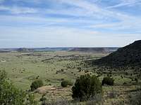
It's really impossible to get lost. It also has a few benches along the way. The terrain is wide open with lots of smaller mesas for as far as the eye can see. It looked like a great place to shoot a wild, wild west movie.
The trail finally makes a left hand turn @ the 2 mile point and you can clearly see the path ahead that goes up and over Black Mesa. It was only 800 feet of elevation and was easy. There is a bench placed at mile marker #3 and it looks down over the terrain.
It's probably the best view on the trail.
The Summit
Once you are up on the mesa, it's about another mile or so of hiking on flat terrain. We were about a quarter mile from the summit when we actually spotted the summit monument. It took us a little over 2 hours to get to the summit, and that's with many stops for photos.
We signed the register, took our photos, had a snack and then headed back down. I was surprised when we passed a lady on her way up. It's such a desolate place, I guess I was expecting to be alone. Then we passed another solo hiker, followed by a group of about 12 students from a nearby university. Then there were two more ladies at the bottom of the mesa taking a rest break. Wow, who would've thought it would be such a busy day on Black Mesa.
The hike back went a little faster, less than 2 hours. We had to stop at the bench on the hill and removed the bottom part of our convertible pants. It was getting hot. Our jackets were right where we left them.
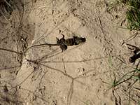
We saw lots of critters and a herd of deer during our hike.
This was my 12th state highpoint.
Comments
No comments posted yet.