The Beginnings of an Idea
Monday & Tuesday May 28th & 29th, 2007
It first started prior to Memorial Day. I decided that I was going to climb New Mexico’s highest point, Wheeler Peak as well as Colorado’s highest point, Mount Elbert on my 4 days off from work.
Following three 12 hours shifts I arrived at home and finished packing only to forget my snowshoes, which turns out, they really wouldn’t factor in to this week of climbing.
I was severely energy deficient this week as I did not arrive to Taos, NM until about 10 or 11 pm. A late arrival due to numerous naps frequently needed in my feeble attempt to re-energize. This lack of energy would carry on through into the next morning. Instead of waking up at 4 am, I didn’t actually roll out of bed until 8 am. This hindered my original plan to climb Wheeler Peak via the 16 mile round-trip Bull of the Woods trail. I instead opted for the more direct Williams Lake Trail. This late start coupled with my route decision would ultimately change my course for the remainder of the week.
I post holed for 2 miles through what was probably close to two feet of snow on the trail leading to Williams Lake. From Williams Lake I made my way towards the steep ridge leading to the summit.
Now, at this point, since I was climbing solo and having made a slightly wrong turn onto a steep slope with more exposure than I was comfortable with, I had to make a decision regarding time. Would I have enough time to reach the summit and get back down before dark or should I turn back now and avoid that risk. Well, the looming clouds overhead would silence any notion my brain had to continue upwards.
![Looking down to Williams Lake]() Looking down the ridge towards Willaims Lake
Looking down the ridge towards Willaims Lake![He looks a little upset]() A Marmot looking none to happy with me
A Marmot looking none to happy with me
Accepting defeat, I slowly made my way back down towards Williams Lake. Slowly that is, until I reached the butt-numbing snow slopes that I would glissade down on. Let me tell you, glissading is such a wonderful way of cutting out a huge chunk of time from a descent, that’s for sure.
Reaching the bottom of the snow slopes, feeling my butt to make sure it was still there, I would realize that I was missing half of one of my trekking poles, an occurrence that would seal the fate for this mission. The last thing that I wanted to do was to attempt a 14er unprepared and without proper gear. So, cutting my losses, I made my way back home, only to be more determined and prepared for the next attempt.
STATS
People Involved:
1
Red Bulls Consumed:
2
Full Days:
4
Highpoints:
4
Summits:
5
Total Hours Slept:
18
Miles Hiked/Climbed:
28
Miles Driven:
2064
Elevation Gained:
9900 feet
Chances that I will torture myself like this again:
1,000,000:1
![Williams Lake Panorama]() Williams Lake Panorama from my 1st attempt
Williams Lake Panorama from my 1st attemptDay 1: Renewed Determination
Sunday June 17th, 2007
Not only renewed determination but extra plans as well.
This time I figured with a fair amount of suffering I could in 4 days potentially reach the high points of New Mexico, Colorado, Kansas and Oklahoma.
So more prepared this time, yet still coming off of three 12 hours shifts I drove for 9 hours to Taos, NM. This would begin my epic journey!!
Red Bulls consumed today – 1.
So after 24 hours with no sleep, I would finally enter quiet and darkness.
![Taos, it s where the Wild Things are]() Watch out for monsters throwing boulders!!
Watch out for monsters throwing boulders!!Day 2: Still Determined!! Wheeler Peak – 13,161’ & Mt. Walter – 13,141’
Monday June 18th, 2007
![Steep slope leading to the summit of Wheeler Peak]() Steep slopes on Wheeler Peak
Steep slopes on Wheeler Peak
This time around I would wake up between 4 am and 5 am. I would get ready and make the short drive to the Taos Ski Valley where my morning would truly begin.
0630 - This would be my start time as I made my way along the trail to Williams Lake. WOW!! What a difference 3 weeks can make! The snow along the trail to Williams Lake was completely gone.
![Williams Lake Reflection]() Williams Lake Reflection
Williams Lake Reflection![Final Ridge Leading to Wheeler Peak s summit]() Wheeler Peak in View
Wheeler Peak in View
This time
no post holing! I quickly made my way through the trees and back up the ridge towards the summit. Whereas last time I had a couple of snow crossings, some that were chest deep, this time I had only one snow crossing and was able to bypass the others. From the ridge, I slowly and methodically trudged my way through the loose rock and occasional scree to reach New Mexico’s highest point.
I spent a good 30 minutes on top talking with a couple from California and then made my way across to the summit of Mount Walter.
Now normally descent time is cut in half for me, but this would not be the case for me today.
On my way down there was a section of steep snow that I was going to glissade down on. The problem was that it was warm enough out and my ice ax did not feel like it was biting into the snow enough for a good self arrest. The fallout at the bottom of this steep section of snow was a good drop off where I could have easily tumbled out of control.
Too far down on the slope to climb back up without slipping, I decided to traverse the snow slope for about 30-40 feet to my left to reach some stable footing on rock rather than snow.
Although tedious as it was, I chopped foot holds for my right foot and holds for my left knee and slowly made my way over to safety. Once I finished that section it was pretty much a safe descent from that point onward. I had officially made it up and down Wheeler Peak safely.
Without resting, only stretching, I hopped in my car and made my way towards Leadville, CO where my 2nd day of climbing adventure would begin.
Mapquest directions can be confusing at times but I eventually made my way towards my next destination. About 5 hours of driving later, I would reach Leadville, CO.
SLEEP!!!
Day 3: 1 Down 3 to Go! Mount Elbert - 14,440'
Tuesday June 19th, 2007
I awoke at about 4:30 am, got ready and made my way towards the North Trailhead. Directions were great for both the north and south trailheads but mileage was lacking. When I arrived at the North Trailhead the map did not list mileage but the north approach appeared longer than the south so I changed plans and headed towards the South approach.
The first 2 miles of the approach were along a 4 X 4 road. I was passed about a mile up the road by a 4WD SUV. Amazingly enough, to my surprise, I passed those same people along the trail. I guess that I was in better shape than I thought.
![Aspen forest road]() Aspen Road leading to the trailhead
Aspen Road leading to the trailhead![Endless views]() View from Mount Elbert
View from Mount Elbert
Up through the steep aspen forest and onward to the gradual, sometimes steep slopes to the summit, I went.
I was on top of Colorado before my planned turn around time and had about 30 minutes to enjoy the summit. While I was there I got to have some pleasant conversation with a couple from Quebec that had just come from visiting Longs Peak.
Maybe it was lack of sleep or maybe I’m just directionally challenged, but on the way down I missed the trail that was covered with snow and got slightly off course. I was to the right of a 40-50 degree snow slope that continued all the way down to a decent sized cliff. I continued down hoping to find a quick fix by crossing on solid ground but no such luck. The last thing I wanted to do was climb back up 1000 feet to regain the correct trail. I had snowshoes with me, but after checking the depth of the snow (about 4 feet deep), the angle of the slope (40-50 degrees) and the temperature (70-80 degrees), I decided it would be safer to climb back up the way I came down than to try to traverse across the bottom of what I personally deemed to be an unstable slope.
To make matters worse, the clouds were building near the summit. So, in fear that a thunderstorm was brewing, I covered about 1000 feet in about 15 minutes (my altimeter on my watch will vouch for this). At 13,000 feet, it was not an easy task.
I regained the trail and quickly made my way back down, passing a pair that I came across when I was on my way to the summit and they were on their way down.
Now, I really felt like I was in the best shape of my life. Back to the car and on my way to Kansas where the easiest of the highpoints would be.
I originally planned to visit Kansas’ highpoint tonight but that would have to wait until the morning since I did not arrive to Kansas until about 11 pm and I was exhausted.
SLEEP!!
Day 4: The Final Stretch! 2 Down 2 to Go! Mt. Sunflower, KS & Black Mesa, OK
![Summiting Mount Sunflower]() Summiting Mt. Sunflower the hard way!
Summiting Mt. Sunflower the hard way!
Wednesday June 20th, 2007
Today I decided to get a full nights sleep. 8 hours of sleep never felt better. I think I was finally on my way to Mount Sunflower at about 10 am. I was really having doubts at this point on whether or not I could reach Oklahoma’s summit in the daylight hours. Although doubting, I would still give it a shot.
I topped out in Kansas wearing my winter climbing gear (I had to add some humor to a few pictures), crampons included. I believe the wind chill factor was somewhere around 75 degrees Fahrenheit. This was probably my most demanding high point because I was absolutely roasting in my winter gear.
After a few photos I quickly got out of my winter gear, took a few more shots and made my way towards Black Mesa, Oklahoma’s highest point.
It was about noon and my mapquest directions told me 5 ½ hours to reach my destination. Luckily I gained quite a bit of time by missing a rather unclear turn which put me on Highway 40, quite a bit south of I-70 which is where my directions originally had me going.
If I wasn’t there by 5 pm, I would not attempt it. Give or take a couple of minutes. I arrived to the Black Mesa Trailhead and was on my feet at 5:02 pm. That is even with road construction and being pulled over by the Colorado State Patrol for speeding. For the record though, I was only going about 5 mph over the limit, receiving only a warning and a business card.
Now, I figured it would get dark at 8 pm and Black Mesa is pretty remote so I told myself that if I wasn’t to the summit at 6:45 pm or earlier than I would turn around, no matter how close I was.
Hiking on 5-6 blisters, complete with moleskin I was able to cover 4.2 miles in 1 hour and 22 minutes. That was 24 minutes better than my turn around time. So I snapped some pictures and made my way back to the trailhead, arriving right as the sun was going down. The true test was now to begin. I had to drive home. All highpoints accomplished, I had a 10 hour drive minimum to make it home.
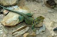
![On the way to Black Mesa s summit]() Along the Black Mesa Trail
Along the Black Mesa Trail![Collared Lizard]() Collared Lizard
Collared Lizard![Oklahoma Cacti Bloom]() Cacti bloom
Cacti bloomThe Drive Back Home
June 21st, 2007
17 hours long, with short naps in between. Let’s just say it sucked really, really bad!!
THE END Obligatory Summit Photos at each Highpoint
![At the summit register]() Wheeler Peak, NM 13,161'
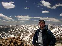
Wheeler Peak, NM 13,161'![On the summit of Mount Elbert]() Mount Elbert, CO 14,440'
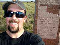
Mount Elbert, CO 14,440'![Summiting Mount Sunflower]() Mt. Sunflower, KS 4039'
Mt. Sunflower, KS 4039'![Self-portrait on Oklahoma s summit]() Black Mesa, OK 4975'
Black Mesa, OK 4975'


Comments
Post a Comment