
-
 11239 Hits
-
 79.78% Score
-
 11 Votes
|
|
Hut/Campground |
|---|---|
|
|
46.00023°N / 11.47889°E |
|
|
Summer, Fall |
|
|
6726 ft / 2050 m |
Overview
 From the bivouac toward Cima Dodici at the sunrise in summer.
Its complete denomination is Bivacco "Ruggero Lenzi" alla Busa delle Dodese in memory of the local alpinist Ruggero Lenzi who was active between the two world wars.
It is a very comfortable logistic point for who has to climb Cima Dodici or is engaged into an historycal hiking tour into the old WWI front of struggle.
This zone has no technical difficulties, but some orientation problems because of the summit land is a plateau with many hills. Its interest is above all of geographic and historical nature. Large panorama toward north and many hikers route toward south!
In case of fog or snow all the guidelines can become truly difficult because the paths on the land are more numerous than those brought back from the cartography.
Informative card
| LOCATION INFO | DESCRIPTION |
|
● SP area&range: Prealpi Venete e Trentine. ● SP group: Altopiano di Asiago. ● SP mountain/rock: Cima Dodici. ● Exactly denomination: Bivacco "Ruggero Lenzi" alla Busa delle Dodese. ● Exactly location: into the large sinking between Cima Dodici and Cima Undici. ● Quota: m. 2,050 ● Topo: view detail from Kompass 1:25,000 map. |
● Lodge: beauty and clean mountain hut in stone and wood; always opened. ● Sleeping places: 6 with mattresses and covered. ● Supplies: fireplace, pottery, table and benches. ● Water: only rain water collected from the roof in a barrel. ● Wood: available only to much distance from the bivouac. Therefore it is necessary not to misuse the small supplyes that the volunteers of the Valsugana valley carry on their shoulders until here! ● Owner: Comune di Borgo Valsugana (Trento). |
Views from the bivouac
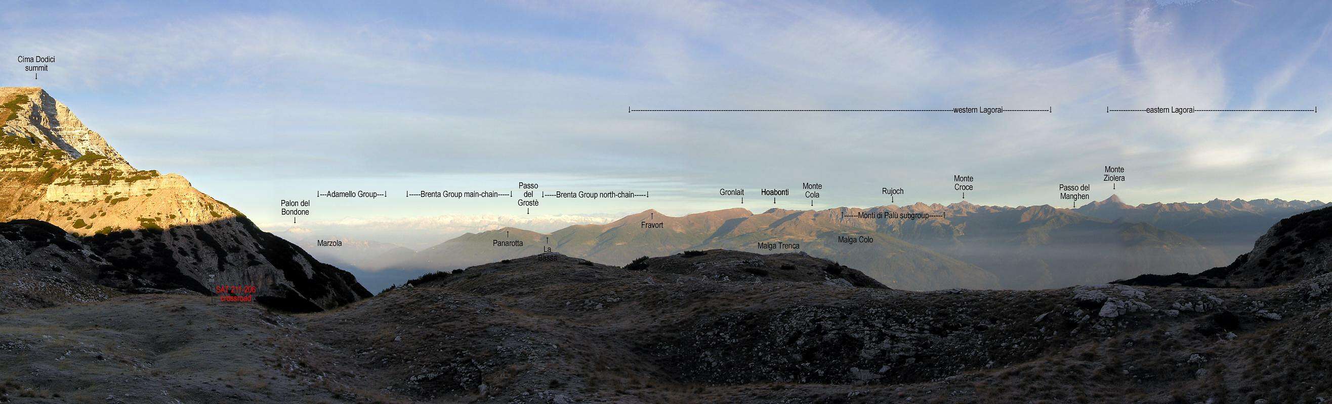
Here is a large view toward north with the Bondone - Marzola - Adamello - Brenta - Lagorai groups. Links are referred to existing SP pages.

And here is a detailed view toward north-west (Adamello-Brenta groups): main mountain/rocks here visible are Carè Alto - Adamello - Crozzon di Brenta - Cima Tosa - Cima Brenta - Cima Falkner - Cima Grostè - Presanella. On the right the far Maddalene chain. Links are referred to existing SP pages.
How to reach the bivouac
| HOW TO REACH THE BIVOUAC | ROUTE DESCRIPTION | RED TAPE |
|
1) From South by car from Asiago. Along the Val d'Assa SP349 until the cross with the white road of Val di Galmarara (on the right side). From here 9 Km on white road until the parking place of Malga Galmarara (m. 1,614).
● When to climb: summer, fall, winter. ● Essential gear on winter: dressed and heavy shoes, sleeping bag, water, snow raquets or mountaineering ski. |
The hiking route here
described follows when possible the ancient roads of war and not the
alpine paths. It is a little longer and little more “historian” but the
time of distance changes little. And so: from the parking to always
follow the old road of war; to leave on the left the bivouac Tre Fontane and to continue until the Bivio Italia crossroad where the
Baito Italia bivouac is found. To continue along the military road of
right until catching up the Baito del Cuvolin bivouac (m. 2,021),
situated to right and similar in its aspect to the Bivacco Italia
bivouac. Here you must abandon the war road and follow instead the
indications that leave from the left side of the road and lead to the
Busa delle Dodese bivouac. Famous: this path is the shortly one but is
not brought back in the cartography! ● Unevenness: m. 436. ● Time in order to go up: 3,00 hours. ● Time in order to return: 2,30 hours. ● CAI degree of difficulty: T (tourist). |
● Very easy but quite long path. Pay attention during the section Baito del Cuvolin-Bivacco Busa delle Dodese because in case of fog or snow you can have orientation problems (the signs on the land are not more visible). ● The Tre Fontane bivouac (owner: section ANA of Marostica-Vicenza) is always open with large place for eating and 2-4 sleeping places with mattresses without covered. ● The two other bivouacs "Baito Italia" and "Baito del Cuvolin" must be considered only as emergency recovers because no comfort is here: no mattresses, no covered! |
|
2) From North by car from Borgo Valsugana. To follow the indications for the Val di Sella valley following its left street (Olle) until the fourth hairpin curve. On the left space in order to park the car to quota m. 700.
● When to climb: summer, fall, not on winter. ● Essential gear on summer: hiking shoes, wind jacket and water. |
To set off along the dirt
road until meeting marks SAT 211 and SAT 213. To always follow path SAT
311 along the steep Vallon delle Trappole until in a gravelly walloon
under the slopes of Cima Undici top. ● Unevenness: m. 1,350. ● Time in order to go up: 4,00 hours. ● Time in order to return: 2,30 hours. ● CAI degree of difficulty: EE (only for expert hikers). |
● The feature along the Vallon delle Trappole is much steep and laborious one. There are some iron chains for helping your climb. Remember: don't use this path during winter: avalanche danger! ● Essential gear on winter: this distance does not go faced during the snowy season! |
Summits and passages
| ASCENTIONS FROM THE BIVOUAC | PASSAGES AND ROUTES THAT FROM/TO |
|
● Cima Dodici m. 2341 ● Cima Undici m. 2228 ● Monte Ortigara m. 2106 ● Cima Portule m. 2310 |
● Cima Dodici from south: the "natural" approach for who is coming from the Padana plain. |
Maps and books
• Advised book: Luigi Faggiani, "Guida ai Bivacchi del Trentino Orientale", Euroedit, Trento (Italia), 1996.
• Advised book: Walther Schaumann "La grande guerra 1915-18, Volume 3 - Prealpi Venete e Trentine", Ghedina & Tassotti Publisher Limited, Bassano del Grappa (Italia), 1984 (this is the italian version of the original “Schauplaetze des 3 Gebirgskrieges - Oestliche Dolomiten, Sexten, Cortina di Ampezzo”. Colonel W. Schaumann also has founded the association Friends of the Dolomiti.
• History channel: numerous historical references to the war operations during WWI are available into the multimedia encyclopedia Wikipedia. We have chosen this only external link one because the material in the WEB is truly too much wide. The various national versions of Wikipedia concur to form a picture of the facts to my opinion enough objective. See the italian, english and german version. To see expecially the pages dedicated to this frame of operations see in italian Battaglia degli Altipiani, in english Battle of Asiago.