Introduction
Carrauntoohil (1039m AMSL) is the highest summit on Ireland. Together with the Macgillycuddy's Reeks and Ring of Kerry route within/around the Killarney national Park, it is a fun hike with dramatic scenery, although weather, similar to the British Isles, is often unpleasing and unpredictable.
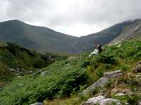
![]()
Carrauntoohil from Coomcallee valley |
Due to the limitation of my holidays, this trip was made possible within a weekend, departing from London. We flew to Kerry Airport, connected to Carrauntoohil by taxi and stayed over night at Killarney International Youth Hostel, north of Killarney lake (Lough Leane).
The hike was an easy-medium hike in terms of difficulty. We went as a group of 4 (3 guys Haru, Vincent, Edward and 1 girl Witty). One of the guys felt that it was a difficult scrambling at one point. However, I am glad that he eventually made it.
My idea of climbing Carrauntoohil came from a couple reasons:
- In the last few years, my Hungarian friend Andras, who are very fond of Apline hiking, took me to a couple of European country highpoints, including Olymus (Greece) and Triglav (Slovenia). Therefore, my interest in hiking and particularly begging country highest summits were born.
- Ryanair connection from London to Kerry made a weekend trip to Carrauntoohil possible. And it costed us only £45 for a return ticket/person.
- After consulting my Irish colleague Aodhan (Yes, his name also sounds Irish!), I knew that Kerry National Park has one of the Irish nicest sceneries.
- My fellows in my Rockhoppers Mountaineering Club also recommended this area.
- Called up 3 friends (literally all novices) one night to ask if they were coming with me. Surprisingly, all of them said YES immediately so that we booked the trip for 4 of us straight away.
Timetable / Summary
25 July 2009 (SAT)
08:10 Flight departed
London Stansted Airport
09:30 Flight arrived
Kerry Airport
10:15 Taxi
10:30 Dropped down heavy stuff at the hostel
10:50 Taxi arrived
Cronin's Yard (60 Euro from airport to Cronin's Yard)
11:15 Walk began
12:30 chose the route on the right (west) of Lough Gouragh lake; ascended to the hill
13:45 arrived at 800m level, near top of Devil's Ladder; turned sharp right to ascend NW towards Carrauntoohil
14:15 arrived at
Carrauntoohil (1039m AMSL)
LUNCH
14:45 Left Carrauntoohil
15:15 arrived at top of
Devil's Ladder (734m AMSL); descended down Devil's Ladder gully
17:00 Back to
Cronin's Yard
Taxi (25 Euro)
18:00 Back to hostel
20:00 Dinner near hostel
11:30 Bed
26 July 2009 (SUN)
08:00 Got up; Breakfast
10:00 Left hostel; walk along
Lough Leane (Killarney Lake) towards Killarney
13:00 Lunch at
Killarney
14:30 Taxi left Killarney for the airport (28 Euro)
16:10 Flight left
Kerry Airport
17:45 Flight arrived at
London Stansted Airport
One thing worthwhile to mention is that taxi in Ireland is quite expensive. we spend just over 100 Euro for the 3 taxi trips, while the first trip covering about 20km costed 60 Euros. However, we found that renting a car does not save us money either, if we just mainly travel to Carrauntoohil.
First Day - Straight up the Mountain
25 July 2009 (SAT)
![Beginning at Cronin s Yard]() Vincent, Witty and Haru beginning the hike at Cronin's Yard
Vincent, Witty and Haru beginning the hike at Cronin's Yard
Our flight arrived at Kerry Airport at about 9:30am. However, it seemed nowadays the Irish Immigration was very strict. It took quite a while for two of my friends to clear the immigration because they held non-EU passport. They also asked detailedly where we would go, what we would do, when we would leave the country, where we stayed. Therefore, ideally you better book the accommodation in advance and present them a clear itinerary about your trip in order to get into the country.
![Beginning rubbly path]() The path full of rubbles at the beginning
The path full of rubbles at the beginning![Infamous Devil s Ladder]() The infamous Devil's Ladder unveiled its face.
The infamous Devil's Ladder unveiled its face.
Eventually, after filling up my water bottle at the tap (as per most of my trips, time is precious for the mountain so that I always just fill up my water bottle wherever I can and shoot off straight away), we jumped into a taxi at 10:15am. First stop was at Killarney International Youth Hostel (part of IYHF) to drop off our heavy stuff. Then we continued our journey to the foot of Carrauntoohil.
At 10:50am we arrived at Cronin's Yard (145m AMSL). There was a carpark and a café, manned by proper ramblers. They even sold Carrauntoohil T-shirts. What a pity, I forgot to buy one there. Café contains bathrooms and a big shower room. All in all, it is a good place to refresh yourself at the beginning of the big hike.
We set off for the walk at 11:15am, walking down SWS towards Coomcallee valley. The route is a rocky, but paved path. After about 1.5km, there is a point we needed to cross the river Gaddagh onto the west side (201m AMSL). It was a bit tricky to find a decent spot to cross because the river at that point was quite wide and there was no bridge/proper crossing stones. After negotiating this crossing, we proceeded further SWS-wards. At 12:30, we arrived at a junction right before the main path crossing the river again. This junction was not very obvious, but we were tipped off by the rambler looking after the café that this smaller route on the right was the route we wanna use if we wanted to avoid the nasty Devil's ladder.
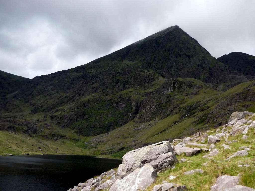
![Carrauntoohil & us]() Carrauntoohil and us
Carrauntoohil and us![Refuge]() A refuge found when we were ascending
A refuge found when we were ascending![Path to gully 1, 2 & 3]() The path braching westward to gully 1, 2 & 3 to the summit
The path braching westward to gully 1, 2 & 3 to the summit
We turned right and went up to this smaller path. Soon after that, it was difficult to find the path and you need to figure it out very carefully, although it is also marked as a spur path on the map. After just over 1km walk, the path began to bend up hill. We found lake Lough Gouragh on the left. The path requires a bit of exposed scrambling, where at one point Vincent felt quite scared to ascend. However, we eventually got through. Witty gave her a push (technical advice) and I was glad that he overcame the fear eventually.
When we arrived at 500m level, there was a little valley, with a path branching up west to approach the 3 steep gullies NW of Carrauntoohil. We decided not to try that route because we were as a team not perfectly ambitious and confident enough for that challenge, plus the weather was not great, still raining a bit. Therefore, we kept leaning on the east face of Carrauntoohil and ascended southwards. It was getting mistier and foggier.
![A view on the ascend]() Broad and beautiful view of the valley can be seen even at the ascend route.
Broad and beautiful view of the valley can be seen even at the ascend route.
At 1:45pm, we arrived at 800m level, on the ridge between Devil's Ladder and Carrauntoohil. With low visibility and certainly not able to see Carrauntoohil, we ascended tiredly in the freezing wind, trusting the map and the compass. At one point, Haru and I were ascending faster in the front while witty and vincent were behind. We could not see them because of the thick fog, but barely heard their voice. Seemed like they were asking "How long do we still need to go? Which direction? Are we lost?" However, as a guide (unofficially), I could only shout to affirm them we were on the right course, though I was even not 100% sure. This last session up to the summit was much longer than I anticipated (I thought it could take only 10min).
![Carrauntoohil Summit]() At Carrauntoohil (with a big crowd behind)
At Carrauntoohil (with a big crowd behind)
Finally, after 25min of battle against the freezing wind and rain, Hara and I arrived at the highest summit of Ireland,
Carrauntoohil (1039m AMSL) at 2:15pm. Witty and Vincent also arrived after 5 min. There were a very stable summit cross and a sitting level shelter (so it does not shelter us very well). We still managed to take a number of photos in the deep dog and rain. Then we sat down to eat something simple for lunch. Apart from seeing a couple of hiking groups on the route and around the top, we sat down at the shelter with a couple, who were training around the region and also made their way up to this summit. Funnily, we saw them again at the bottle of the hill, and in Killarney on the next day. We stayed at the top for 0.5 hr (which is not an easy task coz of the wind!!) and then we descended along the same route towards Devil's Ladder.
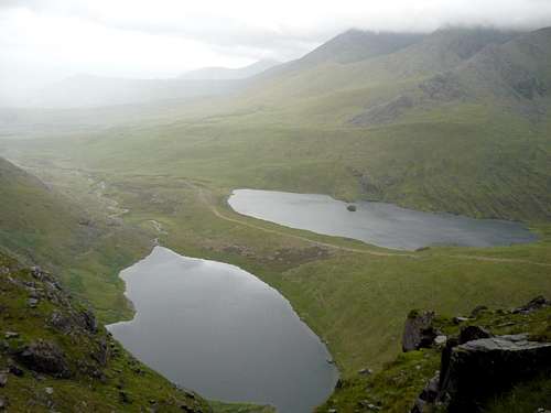
![]()
Looking down to Devil's Ladder Pass |
The view at the pass, the head of Devil's Ladder(734m AMSL), was amazing! At that level the clouds gave way. One can see the entire Gaddagh River valley. Although I planned to go pass Devil's Ladder and descend from the other peak on the east side (Cnoc na Toinne), we arrived at Devil's Ladder and voted to go down the Devil's Ladder. Before other hikers warned me not to use Devil's ladder because there are lots of loose rocks. However, when we went down there, it was not that dangerous. Instead, it was very muddy (= dirty), especially in the wet situation, and you need to scramble to decend or ascend. Therefore, I still do not recommend using Devil's Ladder. We negotiated down this Devil's Ladder slowly. Especially Witty and I just took our time, making sure we did not fall down to make our whole body muddy or cutting ourselves with big boulders.
From the bottom of Devil's Ladder back to Cronin's Yard was also a long walk, taking just over an hour. And I stepped my foot into the water eventually when I crossed river at the very last session of the walk. It was such an unpleasant experience coz I have to walk with the wet boot for the entire evening and following Sunday. Just before we came back to Cronin's Yard. We saw the rambler looking after the cafe running towards us. Then we realise he is simply also a mountain lover. That's why it looks after the cafe. Perhaps he was running up to Carrauntootil at the late evening time and came back within a few hours.
At 5pm, we came back to Cronin's Yard. Taking a short rest and calling the taxi, we were eventually back to the hostel at 5:50pm.
The hostel was originally a very big house, belonging to a local wealthy family. Now, it comes a very nice hostel,setting on a land of big garden. We had a shower and headed off to a bar (normal pub price) in a hotel at the junction to the main road not far from the hostel to eat dinner. Although I said "normal price", eating out in Ireland is generally expensive, even compared with UK.
Second Day - Retreat around Killarney Area
26 July 2009 (SUN)
Sunday was a retreat in Killarney. We walked from the hostel down to the water front of Lough Leane (Killarney lake). It was not an easy route because the north of the lake was occupied by a golf course. We walked around the lake towards the castle southwest of Killarney. However, before reaching there, we turned left into Killarney town, walked around and had lunch there.
At 2:30pm, we jumped onto the taxi for the airport. It was an early finished day and also the end of our weekend trip, climbing the highest summit of Ireland.


Comments
Post a Comment