Introduction
This trip report is created as a though similar, alternative route to Vordergrauspitz (means front Grauspitz, the highest summit of Liechtenstein, 2599m AMSL) to McCannster's report posted in 2006. The differences are:
1) I took a mainly one-way route other than a return route
2) This route almost eliminated all dangerous ridge sections, which I resolved not to climb as a solo hiker.
3) This one-way route idea made the hike a 1.5 days event other than a 1-day climb.
4) So the whole trip enabled me to climb 3 peaks:
Naafkopf (on the first day, which is a half-day hike; the summit exactly at the meeting point of Liechtenstein, Austria and Switzerland),
Hintergrauspitz (or Schwarzhorn) AND
Vordergrauspitz (or Grauspitz)
In anycase, McCannster's post is also very useful. It gave me vital information to finish my trip! Therefore, you may look at different trip reports and design your own route.
![Grauspitz Ridge]() This one is a standard south face photo for Grauspitz (the left summit, at 2599m AMSL). On the right is Hintergrauspitz (2570m AMSL) This ridge is also too difficult for me to transverse so that I almost gave up to go to Grauspitz... This valley is called Schafälpli.
This one is a standard south face photo for Grauspitz (the left summit, at 2599m AMSL). On the right is Hintergrauspitz (2570m AMSL) This ridge is also too difficult for me to transverse so that I almost gave up to go to Grauspitz... This valley is called Schafälpli.Trip Summary
Here is the timetable of the trip:
29/8 Saturday
09:50 arrive at Zurich Airport
taking trains & buses
13:00 arrive at Malbun, Liechtenstein (1600m AMSL)
hike to Pfälzerhütte
15:00 arrive at Pfälzerhütte (2108m AMSL)
take a short rest
16:00 set off to hike up to summit Naafkopf
17:00 arrive at
Naafkopf (2570m AMSL)
18:00 arrive back to Pfälzerhütte for dinner
sleep the night at Pfälzerhütte
30/8 Sunday
07:30 set off from Pfälzerhütte
09:15 passed through Barthümeljoch (2305m AMSL, a pass between Austria and Switzerland)
hiked across the back of Ijes valley
10:15 began to climb up the unnamed ridge from 2050m AMSL (at the back left side of Ijes Farm, Ridge A)
11:00 at top of this Ridge A (2370 AMSL), at the T-junction with the other ridge (Ridge B), went up to Hintergrauspitz, turned right to ascend to Hintergrauspitz
11:50
Hintergrauspitz (also called Schwarzhorn, 2570 AMSL)
rested and struggled about whether to go to Grauspitz... for 1 hr!!
12:45 began to descend to the ridge I came up from
13:15 arrived at the point just before the above mentioned ridge T-junction, turn sharp right and cut down to the valley Schafälpli on the south face of Vorder+Hintergrauspitz ridge
Walked across the steep and loose rock+boulder, diagonally and directly shot up to Vordergrauspitz
14:30
Vordergrauspitz (or Grauspitz, 2599 AMSL)
14:45 descended back through the same route, the ridge T-junction, and the unnamed ridge
15:30 arrived at near Ijes farm
18:10 with cable car Älphibahn descended to Malan and take a train to leave the area
Route Details - Day 1
![View from Sargans]() That's looking from Sargans (in Switzerland) to the Grauspitz mountain range. But certainly, on this day, I can't see the top at all.
That's looking from Sargans (in Switzerland) to the Grauspitz mountain range. But certainly, on this day, I can't see the top at all.
As I came from London to Liechtenstein and Switzerland only for a 4-day long-weekend trip, I, as usual, tried to avoid arriving the night before to save one night of accommodation and in any case it could be only a short sleep. Therefore, I chose to arrive at Zurich airport with an early flight, arriving 9:50am, on 29/8 (Sat).
It meant that, once I arrived at Liechtenstein, it would be already midday. Therefore, I designed a route to hike for a half day up to Pfälzerhütte, the mountain hut run by Liechenstein Alpen Verein (LAV), and, if I had enough time, I could go up to Naafkopf and back. The main hike to Grauspitz was on the next day.
My train journey was as follows:
Zurich airport - Zurich HB - Sargans
Then change to Liechenstein bus:
Sargans - Vadus(Au) - Malbun
![View of Malbun]() View of Malbun from the route going to Pfälzerhütte
View of Malbun from the route going to Pfälzerhütte
I arrived at
Malbun (1600m AMSL) bus end stop at around 1pm. Then I began to walk up along the trail on the West side of Malbun, which is the fastest way to Pfälzerhütte. I took this route instead of the longer Panaramic Route (through Sareiserjoch and Augstenberg) because it was too cloudy/foggy to have any view from any top. Also I could save time for the possibility to do a return trip to Naafkopf. This hike took me up to the ski lift I have used when I was skiing there in March. One can see the valley was absolutely full of snow in winter and completely green in summer time. At the pass on the top of the route, there is a big group of keen hikers (the cows) around.
![Pfälzerhütte]() Pfälzerhütte at 2108m AMSL; on the border between Liechtenstein and Austria
Pfälzerhütte at 2108m AMSL; on the border between Liechtenstein and Austria
Easily, the route brought me to
Pfälzerhütte (2108m AMSL) at 3pm. After checking in at the hut, signing the book and lightening my backpack, I began to shoot up to Naafkopf at 4pm.
![Naafkopf]() Best picture I could make on such a gloomy day on Naafkopf, at the intersection of Liechtenstein, Austria & Switzerland
Best picture I could make on such a gloomy day on Naafkopf, at the intersection of Liechtenstein, Austria & Switzerland
At 5pm, I arrived at
Naafkopf. Lying on the Rätikon range, Naafkopf is at the point where the 3 Alpine countries meet - Liechtenstein, Austria and Switzerland. Currently, the summit cross collapsed and hanging on the Swiss side of the summit. The weather was still bad that I could not see any thing further than 20m. Therefore, the best thing I could do was to sign the summit book and take some photos. Then I returned at 5:15pm and arrived back at Pfälzerhütte at 5:50pm.
The hut served dinner served from 6pm to 7pm. As per other bloggers mentioned, the food is really good there!! Not too expensive and good taste, good value. There was no shower, but washbasins with hot/warm water. Price in the big dorm was quite economical.
Route Details - Day 2
![Grauspitze northface]() photo taken next to Pfälzerhütte, showing the north face of the Grauspitze range. The nearest summit on the top left is Hintergrauspitz, then false+true summits of Grauspitz and Falknis is the third one.
photo taken next to Pfälzerhütte, showing the north face of the Grauspitze range. The nearest summit on the top left is Hintergrauspitz, then false+true summits of Grauspitz and Falknis is the third one.![FL and ÖS junction]() junction where I turned left, cross the border to Austria side and to hike SES towards Barthümeljoch pass.
junction where I turned left, cross the border to Austria side and to hike SES towards Barthümeljoch pass.
On the next day (30/8 Sun), the hut served breakfast from 7am. Nevertheless, it would be too late for me if I wanna set off at 7am-ish in order to have confortable time to finish my big hike and meet the Älphibahn at Malan side with my prebooked 4:30pm reservation. Therefore, I got up at 6am, ate my own food as breakfast, paid my stay at 7am when the hut counter began to be manned and shot off at 7:15am. Thanks God, it turned out to be extremely clear day with completely blue sky (and it was even too sunny/hot through out my afternoon hike!) Therefore, I took loads of sunrise pictures around the hut. That was the first time I could see the summit Grauspitz. Looking from the hut, it is a whole mountain range: (from nearer to further)Ijesfürggli pass, Hintergrauspitz, Vordergrauspitz and Falknis.
So, I actually left the hut at 7:25am and walked up towards Naafkopf direction (again). Very soon after learving the hut, there is a junction with a path cutting to the left, across a rotating gate to cross the border from Liechtenstein to Austria. The sign stated direction Schesaplana Hütte. Then walking towards Barthümeljoch pass, I found a German guy chased up from behind. at some point we began to walk together. He turned out to be my good companion through out my hike to Hintergrauspitz.
It's worthwhile to mention this guy, instead of staying in the hut as I did the night before, he slept on top of Naafkopf, really tough guy.
At 9:15am, we walked across
Barthümeljoch pass at 2305m AMSL and turned right towards Ijes Farm (meaning crossing from Austria into Switzerland). Soon Ijes Farm and Ijes Valley were under our view. We thought about cutting down to the valley along the marked route (which should exist). Unfortunately, we lost the marked path somewhere and we turned out to walk down the dodgy and fairly steep plants+rocks terrain. Anyway, we walked pass the back of the valley (not through the farm) so that we at least did not loose the entire height gain to the farm altitude of 1950m. We arrived at the foot of an unnamed ridge A(as also mentioned on McCannster's post) 2050m AMSL at 10:15am. This ridge is on the northwest-west side of Ijes Farm, extending almost reaching the farm house. Right before the foot of the ridge (east side of it), we crossed a nice little river where you can few up your bottle (and you better do so if it is a hot day).
![Ijes Farm Ridge]() After dropping down on a half way from Barthümeljoch to Ijes Valley, this photo was taken, looking W, showing the route we have taken to climb up to Hintergrauspitz.
After dropping down on a half way from Barthümeljoch to Ijes Valley, this photo was taken, looking W, showing the route we have taken to climb up to Hintergrauspitz.![View down to Ijes Farm]() View from Ridge A down to Ijes Farm (looking SE-E)
View from Ridge A down to Ijes Farm (looking SE-E)![Hintergrauspitz]() Hintergrauspitz, Jesus & Maria and me
Hintergrauspitz, Jesus & Maria and me![Ridge from Naafkopf]() View from Ridge B: It shows the south face of the ridge from Naafkopf (top right) to Hintergrauspitz. That's almost impossible to climb from Naafkopf along this ridge to Hintergrauspitz, 1500m distance.
View from Ridge B: It shows the south face of the ridge from Naafkopf (top right) to Hintergrauspitz. That's almost impossible to climb from Naafkopf along this ridge to Hintergrauspitz, 1500m distance.![Ridge and Grauspitz]() View from Hintergrauspitz looking SWW to Grauspitz. The ridge looks very severe, steep and dangerous. The top left (lower point) is the false summit, which I encountered, before reaching the true summit (second from the left) Grauspitz 2599m AMSL.
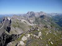
View from Hintergrauspitz looking SWW to Grauspitz. The ridge looks very severe, steep and dangerous. The top left (lower point) is the false summit, which I encountered, before reaching the true summit (second from the left) Grauspitz 2599m AMSL.![Hintergrauspitz NEE view]() This view is from Hintergrauspitz looking NE-E. The pass in the middle of the photo is Pfälzerhütte's location. The summit at top right is Naafkopf.
This view is from Hintergrauspitz looking NE-E. The pass in the middle of the photo is Pfälzerhütte's location. The summit at top right is Naafkopf.
Then we began to climb up the ridge. Actually, I would say this ascend was the most prolonged ascend of the day. At 11am, we arrived at the top of this Ridge A (2370 AMSL), where it is actually a T-junction with the other ridge (let's call it ridge B) going up to Hintergrauspitz. It is where the first time we can see the full south face of the Hintergrauspitz+Vordergrauspitz ridge, very sharp and steep-fall ridge. We were then inspecting the ridge.(because our original plan was to transverse across the ridge from Hintergraupitz to Vordergrauspitz) Then we turned right to ascend along Ridge B to Hintergrauspitz.
(For those who do not bother about going to Hintergrauspitz and just want to hike Grauspitz, at just around 20m along Ridge B further from this T-junction, you can cut left down to the valley Schafälpli at the south face of Hintergrauspitz+Vordergrauspitz ridge. Then follow the same description in a few paragraphs below...)
This Ridge B already required a bit of scrambling, though not too exposed and easy enough. At 11:50am we arrived at
Hintergrauspitz (also Schwarzhorn, 2570 AMSL). We find a few people there and it is a "reasonably frequented" summit. On one hand, we were glad to be here and sign the book.
On the other hand, we both looked at the Hintergrauspitz+Vordergrauspitz ridge and believe it is not safe to ride along the ridge to Vordergrauspitz. My companion decided he would not do it. Taking a good rest and so much courage, I decided to give it a go, trying it for about 20m, but then I turned back because, at one point, I found myself hanging at a vertical rock with 100m fall down the ridge face!! And I have no ropes and any protection whatsoever. Therefore, I also decided "IT IS NOT FOR ME!". I went back to the cross on Hintergrauspitz, feeling very sad because it was actually not my first attempt to Grauspitz. I came in March earlier this year. However, certainly the snow stopped me at that time so that I changed to skiing! Now, I was sitting on Hintergrauspitz and kept beating myself "why can't I do it?"... Looking across to Grauspitz, we saw a couple of people already there (and apparently we almost had no clue where they climbed up there from!) Meanwhile, my good companion also left me, descending along the northeast ridge to Ijesfürggli pass, then to Malbun to pick up his car.
Meanwhile, I began to think that I should not give up. From afar I began to see a couple of people climbing up to Grauspitz from the south valley Schafälpli. I resolved I also wanted to decend to the valley to give it a go. Then I descended down Ridge B to around 20m before the T-junction (1:15pm,2370m AMSL) , turning sharp right down to Schafälpli valley. Then, instead of seeing some other people climbing up from the valley to the middle of the Hintergrauspitz+Vordergrauspitz ridge and ascending half of that sharp ridge to Grauspitz, I shot directly across the valley (2350 AMSL) and diagonally up to Graupitz, avoiding as much length of ridge climbing as possible. The valley is steep (steeper as nearer to the summit!) and has loads of loose rocks. This made it quite a dodgy hike, though not really dangerous as long as there is no top falling rock. Then not far from the summit, I met a Polish couple coming down. They affirmed me that it was not far from the summit. So I continued to climb up to the highpoint. Once I reached the visible highpoint, it was actually a false summit, but it is where I can leave my heavy backpack, and climb across a 30m safe-enough ridge to the real summit.
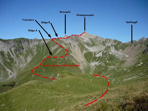
![Route to Grauspitz]() This standard postcard photo for Grauspitz was taken from T-junction. You can see my choice of route aimed to eliminate as much ridge climbing as possible. I have seen some other climbers ascended to the middle pass of the ridge and ascend along the ridge, while McCannster's report suggested they cut across from Hintergrauspitz to Grauspitz at much higher level.
This standard postcard photo for Grauspitz was taken from T-junction. You can see my choice of route aimed to eliminate as much ridge climbing as possible. I have seen some other climbers ascended to the middle pass of the ridge and ascend along the ridge, while McCannster's report suggested they cut across from Hintergrauspitz to Grauspitz at much higher level.![Grauspitz summit book]() Grauspitz summit book and Falknis behind
Grauspitz summit book and Falknis behind![Grauspitz view to NEE]() View from Grauspitz; (from near to far) false summit, Hintergrauspitz, Naafkopf, Schesaplana
View from Grauspitz; (from near to far) false summit, Hintergrauspitz, Naafkopf, Schesaplana
I arrived at
Grauspitz (Vordergrauspitz, 2599 AMSL) at 14:30pm. Thanks God I was still alive!!
I signed the summit book and reckoned it was even just 1/4 full, since it began its duty in 1992. (the book was where I found out the couple I met before the summit were polish) It seemed I was only the 4th person (and likely the last one) to sign the book on that day. After taking photos of the 200km visibility super-clear views (you can see the whole Bodensee) and evidence photos of conquering the summit, at 2:45pm I descended from the original dodgy rocky steep Schafälpli valley back to the T-junction and along ridge A down to the river mentioned previously (to fill up my bottle coz I ran out of water on that hot day!) and walk pass near Ijes Farm (1950m AMSL) at 3:30pm.
![Grauspitz Sunburn]() That's me standing on Grauspitz, photo looking W. The summit behind with a cross is Falknis. Clearly you can see my sun burnt skin on my eye brow. That may prove my success of conquering the summit.
That's me standing on Grauspitz, photo looking W. The summit behind with a cross is Falknis. Clearly you can see my sun burnt skin on my eye brow. That may prove my success of conquering the summit.
Meanwhile, I have already called the Älpibahn to change my booking to 6pm. However, the walk from Ijes Farm back to the Älpibahn station was much longer than I anticipated. And there was even 300m ascend again!! (so if you do this route, make sure you calculate the timing for this session accurately as well). Walking for 2.5 hours and even with some kind farmer giving me a lift on a session of that, I arrived at the Älpibahn station at 6:15pm. The Älpibahn controller told me that I might not be able to get onto the cable car because I was late and after that it was full till the last drive at 7pm. (the cable car only takes 8 people). However, within a minute, he found that there was spare seats and I got onto the cable car at 6:20pm. Finally, I got down to Malan, catched the train and continued my another 2-day hike in the Swiss National Park.


Comments
Post a Comment