
|
|
Area/Range |
|---|---|
|
|
39.65646°N / 77.47284°W |
|
|
Hiking, Bouldering, Scrambling |
|
|
Spring, Summer, Fall, Winter |
|
|
1885 ft / 575 m |
|
|
Overview
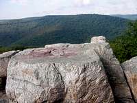
 Near Hog Rock
 Stream in the mountains
Catoctin Mountain is the easternmost spur of the Blue Ridge Mountains, which are in turn a part of the Appalachian Mountain Range. It is a mountain ridge running northeast/southwest for about 50 miles (80 km) from near Emmitsburg, Maryland (north)
to near Leesburg, Virginia (south).
The ridge has no single peak or knob called "Catoctin Mountain" and so is sometimes referred to as the "Catoctin Mountains" (plural).
Catoctin Mountain is best-known as the site of Camp David, a mountain retreat for Presidents of the United States. Hence there are frequent closings of certain areas for security reasons.
 Forest View
Parks along Catoctin Mountain
Note*** these are external links!Cunningham Falls State Park
Gambrill State Park
Catoctin Mountain Park
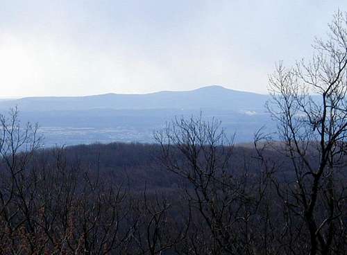
 The Catoctin Mountain View from Chimney Rock
Catoctin Mountain Park

From Washington DC take the George Washington Memorial Parkway north to I495 beltway to I270 north 27 miles to Frederick, MD. Take Route 15 17 miles north to Thurmont, MD. Take Route 77 West, the exit sign is marked Catoctin Mountain Park. Travel approximately 3 miles west on 77 and turn right onto Park Central Road. The Visitor Center is on the right.
From Baltimore, MD. Take I695 beltway to I70 West to Frederick, MD. Take Route 15 North to Thurmont, MD. Take Route 77 West (the exit sign says Catoctin Mountain Park. Travel approximately 3 miles west on 77 and turn right onto Park Central Road. The Visitor Center is on the right.
From Hagerstown, MD, I70 east to Route 66 north for seven miles to right on Route 64 for 1 mile to right onto Route 77 East at a traffic light. Continue on Route 77 East for approximately 7 miles. Turn left onto Park Central Road and the Visitor Center is on the right.
From Gettysburg, PA: Route 15 south. In Thurmont, MD, exit onto Route 77 West(the exit sign says Catoctin Mountain Park, go approximately 3 miles, turn right onto Park Central Road and the Visitor Center is on the right. Public Transportation There is no public transportation to or in Catoctin Mountain Park.
Catoctin Mountain Park is open year-round during daylight hours.
Visitor Center hours: Monday through Thursday, 10:00am to 4:30pm; Friday, 10:00am to 5:00pm; Saturday and Sunday, 8:30am to 5:00pm; closed for the following winter federal holidays: New Year's Day, Martin Luther King Jr.'s Birthday, President's Day, Veterans Day (11/12/07), Thanksgiving Day, Christmas Day.
There are seasonal road closures, normally during the winter months. Please check at the park Visitor Center for more information.
There may be temporary security closures. Please check at the park Visitor Center for more information.
Owens Creek Campground is open April 15 through the 3rd Sunday in November.
Camp Misty Mount, a family cabin rental facility, is open from April 15th through the end of October.
Poplar Grove Youth Group Tent Camping Area is closed from March 1st through April 15th.
Cunningham Falls
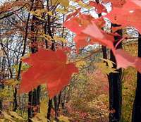 Fall colors
 View From Bobs Hill in Cunningham Falls State Park

Cunningham Falls State Park, located in the Catoctin Mountains, is known for its history and scenic beauty, as well as its 78-foot cascading waterfall. The Falls are located one half mile from the lake in the Houck Area via the Falls Trail.
Directions - Cunningham Falls is located west of Thurmont MD, 18 miles north of Frederick MD along MD Rt 77.
From the Baltimore area: Follow I-70 west to Frederick, and U.S. 15 north to Thurmont.
From the Washington DC area: Follow I-270 north to Frederick, then U.S. 15 north to Thurmont.
From the Gettysburg area: Follow U.S. 15 south to Thurmont.
The Manor Area is 3 miles south of Thurmont, directly off U.S. 15. The Houck Area is west of Thurmont. Follow MD Route 77 west, four miles to Catoctin Hollow Road.
Cunningham Falls State Park
14039 Catoctin Hollow Road
Thurmont, MD 21788
(301) 271-7574
Call 1-888-432-CAMP(2267) for reservations
Gambrill State Park
 From the North Frederick Overloook
Gambrill State Park has its beginnings when public-spirited conservationists of Frederick County purchased this tract of land on Catoctin Mountain and donated it to the City of Frederick to be used for a municipal mountain park. There are many trails in the area, but many of them are near picnic areas, roads, or buildings. It's a nice area to take the family, especially with children.
Directions
From Washington: Take I-270 north to Frederick, which transitions into U.S. Route 15, and continue to Route 40 west (West Patrick Street). Exit to the I-70 west/Route 40 split, bear right and continue on Route 40. Turn right on Gambrill Park Road and follow one mile to the Rock Run Area entrance on your left to reach the campground. Continue on Gambrill Park Road to reach the trail parking lot and to the top of the mountain to reach the scenic overlooks, pavilions and the Tea Room.
From Baltimore: Take I-70 west to Frederick and follow to U.S. Route 15 and then to Route 40 west exit. Follow Route 40 west to Gambrill Park Road on your right as above.
From Pennsylvania: Take U.S. 15 south to Frederick. Take Route 40 west exit and follow to Gambrill Park Road on your right as above.
From Hagerstown: Take I-70 east to Myersville Maryland Route 17 exit (exit #42). Turn left on Route 17 and follow through Myersville to Route 40. Turn right on Route 40 and continue to Gambrill Park Road on your left. Turn left and proceed one mile to the park.
Gambrill State Park
c/o Cunningham Falls State Park
14039 Catoctin Hollow Road
Thurmont, Md 21702
(301) 271-7574
Call 1-888-432-CAMP(2267) for reservations
 Entrance Sign
 View north on the West side of Catoctin Mt in Gambrill St Park
The Catoctin Trail
 blue Catoctin Trail marker
The Catoctin Trail is a 26.5 mi (42.4 km) hiking trail that traverses federal, state, and municipal woodlands along the northern half of Catoctin Mountain in central Maryland. The hilly terrain is typical of western Maryland with large sections canopied under dense forest cover.
The trail's southern section traverses Gambrill State Park for approximately 3.0 miles, then continues north through the Frederick Municipal Forest (Frederick City Watershed), Cunningham Falls State Park (9 miles), and Catoctin Mountain Park (CMP), the last a unit of the federal National Park Service. The trail's northern terminus is at Mt. Zion Road, 1.3 miles north of Owens Creek Campground in CMP. From there, the Appalachian Trail may be reached by traveling west on Mt. Zion Road to Raven Rock Road for two miles.
Camping is permitted along the Catoctin Trail only at Rock Run Campground, Gambrill State Park; the Manor and Houck Campgrounds, Cunningham Falls State Park; and Owens Creek Campground, CMP.
The trail is maintained by the Potomac Appalachian Trail Club.
Rock Climbing
 Wolf Rock
 The Rock wall along the trail
A rock climbing permit may only be issued for Wolf Rock. All other areas within the park are closed to rock climbing and rappelling.
The permittee may call the Visitor Center up to 5 days in advance to make a reservation for rock climbing groups. The party will pick up and sign the permit on the day they are scheduled to climb. Walk in permits are issued depending upon site availability. Climbing helmets are required. Climbing is permitted 10:00 a.m. until 4:30 p.m. on weekdays and from 8:30 a.m. to 5:00 p.m. on weekends. Limit of 25 people total (families, individuals), or 1 organized group not to exceed 25 member.
Permits are not issued on weekends in October due to high visitation parkwide and are not issued during snow/ice conditions or when conditions appear to be unsafe for climbing. The National Park Service will be held harmless from any claim or liability resulting from the permitted use of the area. Climbers may be required to reimburse the United States Government for search, rescue and recovery in the case of accident or other emergency.
Bob Sihler - Nov 6, 2007 8:32 pm - Voted 10/10
Added...I added this to my Blue Ridge Mountains page, okay? If there are any other Blue Ridge pages you mak that aren't children to Catoctin, please feel free to attach them as well.
birdny - Nov 6, 2007 9:06 pm - Hasn't voted
Re: Added...No problem! Thanks!