
|
|
Mountain/Rock |
|---|---|
|
|
39.60318°N / 77.44125°W |
|
|
Frederick |
|
|
Hiking |
|
|
Spring, Summer, Fall, Winter |
|
|
1765 ft / 538 m |
|
|
Highlights


Overview
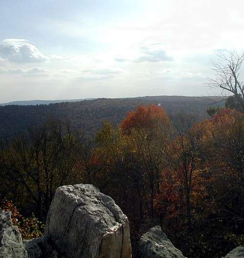 From the South Lookout
Bobs Hill is part of the Blue Ridge Mountains located on Catoctin Mountain in Frederick County Maryland. It lies within Cunningham Falls State Park. Like other hikes in the area you will see an abundance of metabasalt rock formations as you hike up the mountain towards the quartzite summits. The basalt is some of the oldest above-ground exposed stone formations in the world and really make for some interesting and exciting exploration.
There are two lookouts the South Lookout being the better of the two. If you have time you should stop at Cat Rock as well.
Getting There
Directions - Cunningham Falls is located west of Thurmont MD, 18 miles north of Frederick MD.From the Baltimore area: Follow I-70 west to Frederick, and U.S. 15 north to Thurmont.
From the Washington DC area: Follow I-270 north to Frederick, then U.S. 15 north to Thurmont.
From the Gettysburg area: Follow U.S. 15 south to Thurmont.
There are signs from Rt 15 in Thurmont to the area, you will travel west on Rt 77. The parking area for Cat Rock will be on the left side of the road across from the National Park Headquarters on the right.
The Manor Area is 3 miles south of Thurmont, directly off U.S. 15. The Catoctin Trail passes near the Manor Area and can be used to access Bobs Hill from the South.
Also from the Northwest the Catoctin Trail can be accessed via Catoctin Hollow Road. The road is South off Rt 77. You pass the William Houck Area and continue straight a short distance and the blue marked trail will cross the road. Head East (left) on the trail.
Trails
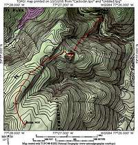 Trail Topo, the Rt from Rt 77 via Cat Rock
From Rt 77 via Cat Rock (7.5 miles)
This is a nice hike up fairly steep terrain to Cat Rock. Near Cat Rock the yellow trail and continue on toward Bob's Hill. The trail climbs a short section and then turns to the left as it reaches the crest of the ridge. From here the hiking is easy. You will soon come to the junction of the blue Catoctin Trail. You want to turn left, and will soon see both blue and yellow trail markings. This will take you south on the Catoctin Trail to Bob's Hill. From the Bobs Hill summit post there are two viewpoints at the end of short side trails, one to the left (North Lookout) and one to the right (South Lookout).
Approach from the East
Provided by seeksit
The ascent of Bob's Hill from the Catoctin State Park Manor Parking Area (immediately adjacent to US Highway 15 south of Thurmont; $3 per vehicle for Maryland residents, almost always on the honor system) is indeed a good strenuous walk. This trail offers 1000 feet of vertical elevation change in a mile and a half: one of the best places for serious hill walking training in the state east of the Allegheny mountains. The trail is wide but rocky. It passes through lovely Mountain Laurel undergrowth in several areas; and in one of those areas, about two thirds of the way to the summit, one can find abundant pink lady slippers blooming in late spring right alongside the footpath.
The trail has several steep sections, the steepest of which is immediately below the "summit" marker (where the two trails to the two lookout points split off). The marker post is actually set at an elevation of just under 1700 feet--the high point of Bob's Hill is a rock pile nearby--a short bushwhack.
From the Catoctin State Park Manor Parking area trailhead (located directly across from the playground area) the trail is marked with triangular yellow reflectors. This is just a short connecting trail, a few hundred yards in length. It intersects with the blue blazed Catoctin Trail after a short steep climb; and from there the trail ascending Bob's Hill is marked by both the blue paint blazes maintained by the Potomac Appalacian Trail Club and the triangular yellow reflectors that appear to be maintained by the State Park.
There is an alternative free parking area a short distance to the south of the Manor Parking area, and across the busy US15 highway. This is at the historic ruins of the Catoctin Furnace (remains of a large iron smelting mill). This parking area is accessable from Rt. 806, the frontage road that parallels Hwy 15. A trailhead from there (no sign identifies it; it starts from the grassy area just up the hill and to the right of a small handicapped parking lot and a separate trail that leads to one of the ruins) leads over a dedicated foot bridge that safely crosses over the busy divided highway US 15. From there the trail enters the Manor Parking Area picnic area. Stay to the left among the picnic sites between Hunting Creek and the parking lot. Follow the creek upstream and you will quickly intersect the well-marked blue-blazed Catoctin Trail where the picnic sites end. Follow the trail right (do not cross Hunting Creek) and ascend via a winding route for a few hundred yards to the intersection with the yellow-reflector-marked spur trail that comes up from the Manor Parking lot trailhead mentioned earlier; turn left at this intersection and continue on to the Bob's Hill summit. This extension adds another 150 to 200 feet of elevation change and perhaps another 0.4 miles of distance to the walk.
Red Tape
Mountain bikes are prohibited on all trails.Service Charges for Manor Area--Day use service charge is $3/vehicle year-round. Out-of-state residents add $1.
Service Charges for Houck Area--Day use service charges are as follows: Weekdays Memorial Day-Labor Day $3/person; weekends and holidays Memorial Day-Labor Day $4/person. All other times $3/vehicle. Out-of-state residents add $1 to all day use service charges.
Camping
Camping--Cunningham Falls State Park offers two camping areas: the Houck Area with 140 campsites situated in five camping loops and nine camper cabins, and the Manor Area with 31 campsites. Bathhouses with hot showers are conveniently located in each camping loop. Each campsite is equipped with a table, fire ring, lantern post and parking area. Some electric hook-up sites are available in both campgrounds. Campsites at the Houck and Manor Areas can be reserved. A camp store offers groceries, camping supplies and souvenirs.There is no camping other than at these designated areas.
seeksit - Jan 9, 2009 5:17 am - Voted 10/10
East approach infoThe ascent of Bob's Hill from the Catoctin State Park Manor Parking Area (immediately adjacent to US Highway 15 south of Thurmont; $3 per vehicle for Maryland residents, almost always on the honor system) is indeed a good strenuous walk. This trail offers 1000 feet of vertical elevation change in a mile and a half: one of the best places for serious hill walking training in the state east of the Allegheny mountains. The trail is wide but rocky. It passes through lovely Mountain Laurel undergrowth in several areas; and in one of those areas, about two thirds of the way to the summit, one can find abundant pink lady slippers blooming in late spring right alongside the footpath. The trail has several steep sections, the steepest of which is immediately below the "summit" marker (where the two trails to the two lookout points split off). The marker post is actually set at an elevation of just under 1700 feet--the high point of Bob's Hill is a rock pile nearby--a short bushwhack. From the Catoctin State Park Manor Parking area trailhead (located directly across from the playground area) the trail is marked with triangular yellow reflectors. This is just a short connecting trail, a few hundred yards in length. It intersects with the blue blazed Catoctin Trail after a short steep climb; and from there the trail ascending Bob's Hill is marked by both the blue paint blazes maintained by the Potomac Appalacian Trail Club and the triangular yellow reflectors that appear to be maintained by the State Park. There is an alternative free parking area a short distance to the south of the Manor Parking area, and across the busy US15 highway. This is at the historic ruins of the Catoctin Furnace (remains of a large iron smelting mill). This parking area is accessable from Rt. 806, the frontage road that parallels Hwy 15. A trailhead from there (no sign identifies it; it starts from the grassy area just up the hill and to the right of a small handicapped parking lot and a separate trail that leads to one of the ruins) leads over a dedicated foot bridge that safely crosses over the busy divided highway US 15. From there the trail enters the Manor Parking Area picnic area. Stay to the left among the picnic sites between Little Hunting Creek and the parking lot. Follow the creek upstream and you will quickly intersect the well-marked blue-blazed Catoctin Trail where the picnic sites end. Follow the trail right (do not cross Little Hunting Creek) and ascend via a winding route for a few hundred yards to the intersection with the yellow-reflector-marked spur trail that comes up from the Manor Parking lot trailhead mentioned earlier; turn left at this intersection and continue on to the Bob's Hill summit. This extension adds another 150 to 200 feet of elevation change and perhaps another 0.4 miles of distance to the walk.