
-
 5686 Hits
-
 84.82% Score
-
 19 Votes
|
|
Route |
|---|---|
|
|
46.19780°N / 10.90560°E |
|
|
Mountaineering, Scrambling |
|
|
Summer |
|
|
Half a day |
|
|
Alpine F+ |
|
|
Overview
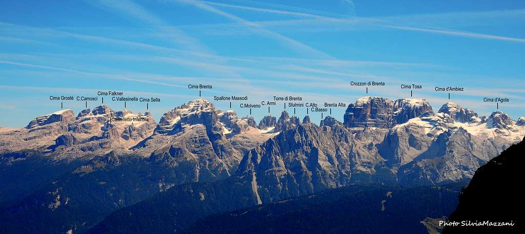
Cima Grostè South-North Traverse
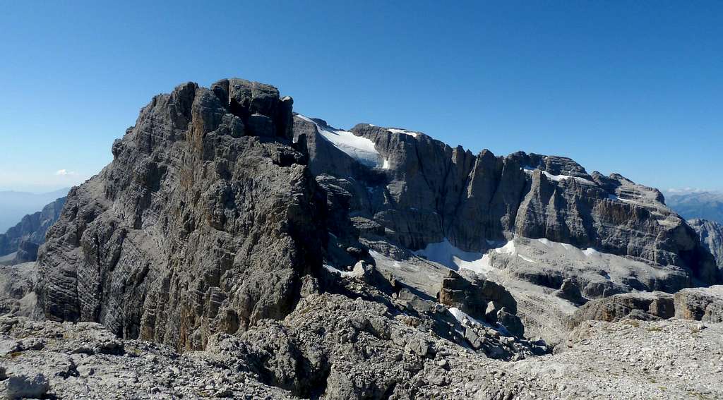
Cima Grosté 2901 m is the Northernmost peak of the central Brenta Group. Belonging to the namesake subgroup, Cima Grosté appears like a mighty rocky castle between the Vedretta Vallesinella Inferiore, towards which it stretches a beautiful wall, and the wide saddle of Passo del Grostè 2442 m, towards which it degrades with rocky steps and ledges connected with the terraces overlooking the valley of Santa Maria Flavona. Along them it runs passing the equipped "Sentiero Benini", which continues to the south on the famous Via delle Bocchette.

Cima Grostè is one of the most popular summit of the Brenta Group, also in reason of the spectacular 360° views, ranging from the Adamello-Presanella group, the Cevedale and obviously the Brenta group. It is frequently and rather easily climbed along the Normal route from the North.
Here it's described a nice alternative to the Normal route from the North, a traverse that reachs the summit along the South side and descends directly to Passo del Grostè along the Normal route from the North.
Getting There
The closest town is Madonna di Campiglio. The starting point to climb is Passo Campo Carlo Magno.
Road access to Madonna di Campiglio m. 1514
- Coming from A22 Brennero Motorway (direction towards South) exit Trento Centro, then follow the SS 45 towards Riva del Garda and Tione, getting to the village Le Sarche. From here take the SS 237 reaching Ponte Arche and Tione. In Tione turn to right and follow the Val Rendena road getting to Pinzolo, Madonna di Campiglio and Passo Campo Carlo Magno.
- Coming from A22 Brennero Motorway (direction towards North) exit San Michele Mezzocorona, then take the Val di Non road, getting to Cles, Malé and Dimaro. In Dimaro leave the main road and turn to left on the Val Meledrio road, reaching Folgarida and Passo Campo Carlo Magno.

|

|
Once getting Passo Campo Carlo Magno, nearby Madonna di Campiglio, take the cablecar to Passo Grostè 2442 m where it starts the route to Cima Grostè.
Route Description
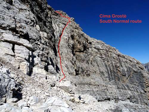
Cima Grostè South side Normal route
Cima Grostè South-North traverse
Difficulty: Alpine F+, max II grade UIAA
Difference in level: 460 m from Passo del Grosté
Exposure: East, South and North
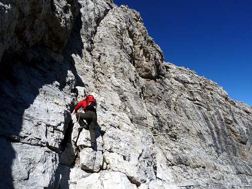
A nice and pleasant itinerary to start climbing on the Dolomites and enjoy the Brenta Group environment, with spectacular views. This tour can be done in both directions. Here it is suggested the S-N direction (to climb up on the South side and descent on the North one), in order to overcome uphill and not downclimbing the most exposed move of the entire climb, a slanting crack on the S side.
Route description
From Passo del Grostè 2442 m, just above the Rifugio Stoppani head to south along the wide plateau along the path 305. A short descent leads into a small basin where it forks the path to the Rifugio Graffer. Ignore this latter, keeping the left path. Signposts indicate the start of the Sentiero "Alfredo Benini" (2562 m, h 1.00). Soon you come to another junction: on the right it starts the path leading to the Northern normal route to Cima Grostè (signpost), our route begins to circumvent the summit leftward in an almost lunar landscape, crossing impressive smooth slabs. The route climbs diagonally left the stony ground, beginning the extensive circumvention of Cima Grostè: after a steep stretch the path reaches the signpost of the "Sentiero Benini". The route follows a system of ledges cutting the Eastern side of Cima Grostè.

After a first iron rope, the ledge continues easily, then it turns sharply to the right getting the marked saddle of Bocchetta dei Camosci 2784 m. Once on the saddle, leave the "Sentiero Benini" and head rightwards (facing in) along a steep scree slope and easy rocks, following cairns and red marks and reaching a little saddle near the base of the rocks. Here head definitely to the left following a ledge, then to the right to reach the start of a slanting right crack.

|

|

|

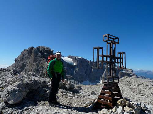
Climb the crack with a few climbing moves (II degree) and exit on easier rocks, traverse left and take a steep track leading to the summit ridge and then to the wide top, where it's located a characteristic cross. Fantastic view to the horizon, to the Adamello-Presanella glaciers and nearby Cima Falkner, while behind it appears Cima Brenta.
Descent - From the summit cross head to North (towards Passo del Grostè) across the wide scree terrace, slightly downill (cairns and marks). The track reachs a small notch, when you start downclimb an easy rock gully and successively a chimney (II degree). After the chimney the route follows scree ledges getting the basal scree, then the path going back to Passo del Grostè.
Essential Gear
Rope, harness and helmet, some slings.
Red Tape

No fees no permits required. Cima Brenta is part of Adamello-Brenta Natural Park, the largest protected area in Trentino, established in the year 1967. It's located in Western Trentino and with its 620.51 square kilometers includes the mountain groups of Adamello, Presanella and Brenta Dolomites, separated by Val Rendena. Follow the "leave no trace" approach.
Huts

When To Climb
The standard climbing season is from July to September.
Camping
Camping is available in S. Antonio di Mavignola (Campeggio Faè, +39-0465-507178).
Bibliography
- Dolomiti di Brenta Tabacco 053