Diamante is a mountain immediately behind the city of Genova and the top reaches 672 meters o.s.l.
The shape of Diamante is easily recognizable: conical with two important humps on the north east ridge.
On the top there’s a fortress erected to protect the city from the assaults during the past centuries. Near Diamante there’s a mountainous chain studded with many fortresses: Fratello Minore, Puin, Sperone, Begato, Castellaccio. Diamante is the highest one, and the namesake mountain is the only one which stands out being isolate.
Being a very popular mountain for Genoeses it’s the destination of many excursions in spring and summer.
Getting There
To reach Diamante with car:
exit from the motorway at Genova Est tollgate and follow the road signs to Molassana and Piacenza along Bisagno valley. When it is possible follow the road along the western bank of the torrent. Prosecute and after five yellow working-class buildings, at a traffic-lights turn left and follow a road ascending to Trensasco.
Alternatively exit from the motorway at Bolzaneto tollgate and follow the road sign to S.Olcese; at the crossroads pay attention at road signs to Val Bisagno and you will arrive at Trensasco.
Both roads lead to Colle di Trensasco, starting point of the ascent.
It is possible to reach it also with a narrow-gauge railway ( from "Genova Manin" to "Casella" ): alight from the train at the coach station of Campi.
Itinerary
To reach the top of Diamante, the FIE ( Italian Excursionist Federation ) maps out two routes.
DIFFERENCE IN HEIGHT 280 m.
The first is on the North East ridge of the mountain.
Path mark: three red circle.
Starting at Colle di Trensasco 392 m, the medium slope path ( yellow line in the photo) goes linearly along the ridge separating the Polcevera and Bisagno valleys. Trees and bushes disappear nearly soon followed by meadows. Rarely it's necessary to scramble but there are not difficulties.
The path reaches a short plane where the path marked in blue starts. In front of us, the path go up to the fortress. The difficulty doesn't change in the second part of the ascent.
The beautiful 360° view from the summit includes the Apennine chain, with the distant Antola massif (1597 m), and the sea (7 Km southwards). If you are lucky, in a clear day you can catch a glimpse of the northern extremity of Corsica!
The second path ( blue line ) is very longer than the first one but it’s easy as a walk. It starts at the Trensasco col because as far as the first hump the route is the same as the previous path. Afterwards it continues flat on the left running alongside the south-east side of the mountain. Turning right the path arrive at a saddle. The last part of the way is steep but a zigzagging path makes easier the final ascent to Diamante.
The Fortress
Diamante in Winter
All the photos of Diamante with snow are always rare images ! Submit here.
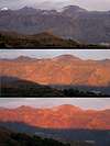
All the photos with strange colors. Nature is always so unforeseeable... Submit here.
Panorama from Summit
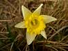
Spring, the season of flowers
Acknowledgements
I thank my friend LIVIOZ because he always supports my pages with many documents!
External Links
The historical fortifications of Genova A detailed and complete description is given of the very interesting system of fortifications running around the borders of Genova along the centuries
Parents refers to a larger category under which an object falls. For example, theAconcagua mountain page has the 'Aconcagua Group' and the 'Seven Summits' asparents and is a parent itself to many routes, photos, and Trip Reports.