
-
 19173 Hits
-
 84.27% Score
-
 18 Votes
|
|
Mountain/Rock |
|---|---|
|
|
34.90740°N / 119.1338°W |
|
|
Kern |
|
|
Hiking |
|
|
Spring, Summer, Fall, Winter |
|
|
6005 ft / 1830 m |
|
|
Overview and Routes
 Eagle Rest Peak
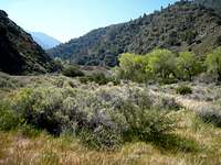 San Emigdio Creek area
Although nearly 3,000 feet lower than the highest peak in the San Emigdio range (Mt. Pinos at 8,831’), the views from the top of Eagle Rest Peak are truly magnificent. The vistas include several of the 8,000+ foot peaks in the San Emigdio range including Mt. Pinos. The summit block is an easy Class 3.
 Summit Block Eagle Rest Peak
 View north from Eagle Rest Peak
Eagle Rest Peak is the highest point in the 97,000-acre Wind Wolves Preserve. The preserve contains an array of habitats and has seen the introduction of Tule Elk. The name “wind wolves” refers to the rolling waves in tall grass caused by the wind. Route 1 below will take you through these rolling waves of grass on the southwest slopes of Eagle Rest Peak.
Route 1
 Meadow below west ridge of Eagle Rest Peak
This approach is from the south. It begins at the Nesthorn Way trailhead near the Pine Mountain Club and proceeds in and along the west and east forks of San Emigdio Creek. After about 2.5 miles, the canyon widens and passage through a large meadow to the right will put you at the base of the west ridge to the peak. There is a faint use trail on the ridge. Proceed towards the sandstone cliffs to the summit.
 Looking north from low on Eagle Nest's west ridge
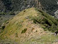 West ridge of Eagle Rest Peak
This route is 11 miles roundtrip with 2300’ gain going out and 1400’ on the return.
Route 2
This route is from nearby Antimony Peak. The route to Antimony is along an old road switchbacking up Antimony’s south slope. From Antimony, the route proceeds along the north/northwest ridge starting just west of the summit of Antimony. The ridge dips down to a saddle at 5520’, over a bump at 6000’, down to another saddle at 5037’, then north up the ridge to about 5400’. From here, the route is west to pick up Route 1 above at about 5600’.
 Eagle Rest Peak from saddle on ridge to Antimony Pk
This route is 11 miles roundtrip with 2400’ gain out and 2900’ on the return.
Route 3
This is a northern approach coming in through the Wind Wolves Preserve. According to the Sierra Club’s HPS page for this route, permission is needed to enter the preserve. See the HPS Eagle Rest Peak page, Route 3, for detailed route information.
Getting There
Route 1Going north on California Interstate 5, exit at Frazier Park exit and turn left on Frazier Mountain Park Road. Go west 12.2 miles to the junction with Mil Potrero Road. Turn right and go west 4.5 miles to Nesthorn Way. Turn right onto Nesthorn and drive about 500’ to the end of the paved cul-de-sac on Nesthorn Way. Leave the cul-de-sac on the right side on an unnamed dirt road (passable with non-high clearance vehicle but go easy) and continue another 500’ to a locked gate. Park here (4850’ elev.) being careful to avoid blocking the gate and to avoid parking on Nesthorn Way. From the parking area, begin hiking on the road along the west fork of San Emigdio Creek.
Route 2
Going north on California Interstate 5, take the Frazier Park exit and turn left. Go 7.2 miles to Lake of the Woods where you continue going straight on the Cuddy Valley Road. Proceed 4.2 miles to a dirt road on the right marked by a sign “Tecuya Mtn Rd.”
Turn right and proceed as follows: at 1 mile turn left at the fork; at 1.4 miles take
a left at the fork; at 1.9 miles go left on road with sign “9N19A; at 4.6 miles, there is a large open area where you can park. From the parking area (6660’ elev.), start down on the jeep road that connects there.
Route 3
See the HPS Eagle Rest Peak page, Route 3, for detailed driving directions.
Red Tape
No permits or authorization are needed for Routes 1 and 2. For Route 3, permission to enter the Wind Wolves Preserve, including having to open several locked gates, is needed from the Preserve headquarters.Camping
There is limited camping within the Wind Wolves Preserve at San Emigdio Campground and Willow Picnic Area Group Campground. However, the camping is limited to weekend days and requires advance reservations (661.858-1115).When to Climb/Mountain Conditions
This peak can be climbed year round, but come properly equipped when there may be snow coverage in the winter. Be sure and check with CalTrans for road condition information during the winter because snow sometimes forces closures along Interstate 5. Furthermore, some roads within the Mt. Pinos Ranger District, including Frazier Mountain Road, are subject to closure during the winter season. Call the Mt. Pinos Ranger District Office 661. 245-3731 for current information.Other Information
Water is available along Route 1 in San Emigdio Creek. Treating the water is advised.USGS Topos: Eagle Rest Peak 7.5 Sawmill Mountain 7.5 Cuddy Valley 7.5 Pleito Hills 7.5
External Links
Los Padres National Forest Current ConditionsCalifornia Dept. of Transportation
Wind Wolves Preserve