
|
|
Area/Range |
|---|---|
|
|
34.28890°N / 117.6458°W |
|
|
Hiking, Mountaineering, Sport Climbing, Bouldering, Mixed, Scrambling, Canyoneering, Skiing |
|
|
Spring, Summer, Fall, Winter |
|
|
Overview
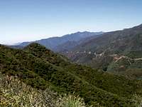
The Transverse Ranges of southern California represent one of the most complex and diverse set of mountain ranges in the United States. They run east-west in southern California bounded by the San Joaquin and Antelope Valleys on the north and the Los Angeles Basin on the south. They include the Santa Monica Mountains, which extend offshore to form the Northern Channel Islands of Santa Cruz, Santa Rosa, and San Miguel off the coast of Santa Barbara County. Three hundred miles east, the Transverse Ranges terminate abruptly in the San Gabriel and San Bernardino Mountains, dropping off into the Mojave and Colorado deserts. Severely folded, twisted, and uplifted, these mountains exhibit extreme differences in geologic age. Sedimentary rocks are most common on the western slopes such as the Santa Ynez and Santa Monica mountains, which hug the coast from Santa Barbara County south to Los Angeles County. In the rugged eastern mountains, granitic and metamorphic rock dominate.The Santa Monica Mountains National Recreation Area and Channel Islands National Park encompass the extreme western part of the Transverse Ranges. There are also three National Forests whose jurisdictions include some or all of the mountains in the Transverse Ranges - from west to east they are the Los Padres, Angeles, and San Bernardino National Forests.
View Larger Map
Aerial views of the Transverse Ranges
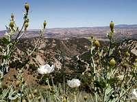
There are countless peaks to climb and trails to explore in the Transverse Ranges. Some of the highlights include Sandstone Peak, the highest in the Santa Monica Mountains, Mt. Baldy, the highest peak in the San Gabriels, and San Gorgonio Peak, the highest in the San Bernardinos.
The Transverse Ranges are one of only two major mountain ranges in the United States that run east-west (the other is the Uinta Mountains in Utah). To the immediate south of the Transverse Ranges are the Peninsular Ranges which run north-south.
Getting There
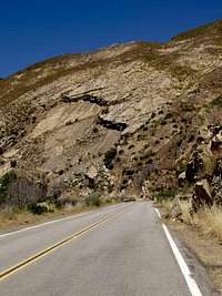
Hwy 101, I-5, and I-15 are major north-south routes through the Transverse Ranges in southern California. In the west Hwy 33 runs north-south through a scenic section of these mountains north of Ojai. In the central part of these mountains, Hwy 210 runs east-west along the southern foothills of the San Gabriel Mountains and Hwy 2 runs east-west along their crest (Hwy 2 is dubbed the Angeles Crest Highway). In the eastern part of these mountains Hwy 18 is a popular route that goes past Lake Arrowhead and Big Bear Lake (Hwy 18 is dubbed the Rim of the World Highway). There are other highways and roads that access the mountains but these are perhaps the most popular ones. A good map of southern California should show these roads and the Tranverse Ranges whose boundaries roughly follow the National Forest, National Recreation Area, and National Park boundaries.
Suggested Map: Pacific Crest Trail 2 (Transverse Range) $10 Order it from the National Forest Store
Red Tape
An Adventure Pass is needed when parking for day use activities (hiking, picknicking, etc.) on the Los Padres, Angeles, and San Bernardino National Forests.
Click here for more info on wilderness permits for the San Bernardino National Forest.
Fire restrictions on the San Bernardino National Forest.
Campfire permits are required year-round in some areas. The permit is free and can be issued by any Forest Officer.
External Links
Tour of the Transverse Ranges
Weather Forecast from the NWS
Los Padres National Forest
Angeles National Forest
San Bernardino National Forest
Santa Monica Mountains National Recreation Area
Channel Islands National Park
Camping
Campgrounds on the Los Padres National Forest
Campgrounds on the Angeles National Forest
Campgrounds on the San Bernardino National Forest
Campgrounds in the Santa Monica Mountains National Recreation Area
Campgrounds in Channel Islands National Park
Visitor Centers

There are many visitor centers which offer information on this diverse area!
Big Bear Discovery Center
Chilao Visitor Center
Angeles Crest Highway (HWY 2)
La Canada, CA 91011
(626) 796-5541
Wed-Sun. 8:00 am - 4:00 pm
Mt. Baldy Visitor Center
Mt. Baldy Road
Mt. Baldy, CA 91759
(909) 982-2829
Daily 8:00 am - 4:30 pm
Grassy Hollow Visitor Center
Angeles Crest Highway (HWY 2)
Wrightwood, CA 92397
(626) 821-6737
Open weekends

Clear Creek Information Center
Angeles Crest Highway (HWY 2)
La Canada, CA 91011
(626) 821-6764
Daily 8:00 am - 4:30 pm
Big Pines Information Center
Angeles Crest Highway (HWY 2)
Wrightwood, CA 92397
(760) 249-3504
Daily 8:00 am - 4:30 pm
Santa Monica Mountains Visitor Centers
Channel Islands Visitor Centers