
-
 7548 Hits
-
 72.08% Score
-
 2 Votes
|
|
Route |
|---|---|
|
|
46.56670°N / 13.14580°E |
|
|
Via Ferrata |
|
|
Summer, Fall |
|
|
Less than two hours |
|
|
Medium hard ferrata |
|
|
Rating the Route (By Hiking Standards)
In Ferrata degli Alpini
0. General: 1552 m to 1911 m. Only the upper 100 m is ferrata. Exposition of the ferrata is south. Gear: Perhaps a ferrata set. There's no danger of falling rocks and the ferrata is very short (a bit more than 90 m). Total grading on the Austrian scale is B/C.
1. Effort: 360 m, 1 h from the parking place.
2. Power: 3 - medium.
3. Psyche: 4 - difficult. The route is very exposed.
4. Orientation: 1 - no difficulties.
Approach
This ferrata does not ascend Monte Zermula, but the neighbouring Zuc della Guardia. But as this summit is unimportant for itself, I propose it is described on the page of Monte Zermula. You start the tour on Passo del Cason di Lanza, 1552 m. See the parent page how to get there by car.
From the pass, follow the marked path No. 442a towards the south. This is also one of the ascents on Monte Zermula. After good 20 minutes you reach the beautiful grassy basin between M. Zermula, M. Pizzul and Zuc della Guardia. Cross it and continue towards Forza di Lanza (saddle), but after you pass the slopes of Zuc della Guardia, you can go directly upwards on the saddle between Zuc della Guardia and Monte Pizzul. This saddle can be also reached by a marked path, which crosses the northern slopes of Monte Pizzul. Just above the saddle there's a cavern from the World War I, where the ferrata starts.
Route Description
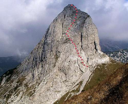
Zuc della Guardia and its south face ferrata - Ferrata degli Alpini.
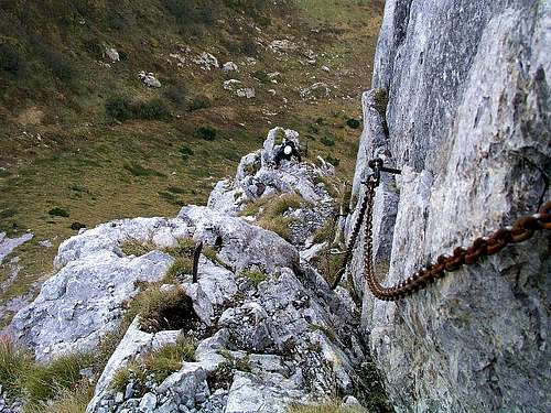
The first vertical wall is climbed by a ladder. Above it, the long steel chain begins, by which the whole ferrata is secured. The chain offers you a comfortable grip, so that climbing is really easy, although on some places the rock is really almost vertical.
From above the ladder, the ferrata crosses some easier rocks and you soon reach a metal box with a book, into which you can log your ascent.
Then the next vertical part starts, requiring also some power in your hands and a clear head. Above it, the terrain flattens and you reach a long and steep ramp, going directly up towards right. You climb a few steep steps, all the time pulling up with a help of the chain. After some 5 minutes you reach the summit ridge and the summit itself.
You descend by the same route, or by the marked route towards the north (I didn't know for it, so also didn't try it, and anyway left my rucksack on the southern entry) - but the N face looks less steep than the S face ( descent ferrata is graded B).