Introduction
![Sunrise in the Cirque de Lescun]() Sunrise in the Cirque de Lescun
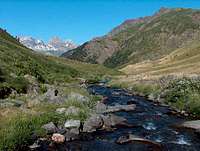
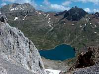
Sunrise in the Cirque de Lescun![valley of Echo]() Valley of Echo
Valley of Echo![valley of Echo]() Valley of Echo
Valley of Echo
The following account is from several years ago already, but I decided to write it since I enjoyed it a lot, and several things seen during this trip are in my opinion quite interesting to tell too. Perhaps also because it was my last "long and wild" stay in the Pyrenees, from the sporty point of view, before I moved to Poland.
The french bank holiday of July 14th came on a Wednesday, and I subsequently booked the whole week as holidays, in order to hike there, knowing that I would not not much free time this year to dedicate to them, and in order to make the best of it. As always, for such occasions of extended stay, I decided to throw my vest in a remote region, where I don't have often the possibility to travel. What to choose ? Perhaps the Ariège, the Catalan side, Venasque, so close but so remote since on the opposite mountainside ?
I finally decided to head in the opposite direction, in the western Vallée d'Aspe, where I started my Pyrenean mountainclimbing adventure many years ago. I had hiked the
Pic d'Anie and the
Visaurin in my early explorations, and each time I was watching them in the skyline from neighbouring areas, they seemed to ask "when will you visit us again ?". Like a pilgrimage then, but, partly also because some other people expressed interest in joining these plans.
These years, at least in the country where I come from, were kind of the emergence of internet, and the french web bloomed with sorts of amator websites about the Pyrenees, including mine (which hasn't changed much, looking nowadays desperately old-fashioned...). Webmasters were somehow all in touch with each other, at least corresponding by mail, and this is the way I quickly got acquainted with Philippe Queinnec and Ollivier Guix.
The first one is the author of
a very sober-looking site, but constantly updated with rare route descriptions, and containing an extraordinary amount of informations. After so many years of activity, his site has become a must-see known by the wide majority of the connaisseurs seeking informations about lost regions, even abroad. I'm sure a fair amount of SPers who visited the range came across it.
The second, at this time, owned
a very photograph-oriented page, with a lot of panoramics made by the then new technology of stitching, which he abundantly described in it. He provided me a lot of tips, and was the person who encouraged the most, and eventually convinced, the most digital-reticent photo amator I was, to switch to these new technologies. His site has changed since then to becore much more succint and pragmatic, and is unfortunately not nuch updated anymore, as Olivier tends now to focus rather on explorations of remote countries like Africa.
I had met Philippe a couple of times before, but not Olivier, who also knew Philippe as well, and we all decided to gather for hiking during these few days. SP existed at this time but was not the unavoidable portal it is now, and this meeting in the Pyrenees reminds me a lot the different SP-gathering trip reports we can read here and there. I elaborated a busy program, whose biggest part was decided with them.
Unfortunately, one half, basically the one I did alone, was not very successful due to ambigous weather, and the best of the trip was undoubtely this colorful triplet of hikes on the eastern side of the Tena valley, the one facing the Aspe valley, made with my friends. Initially planned in bivouac over three days, we decided however to dispatch our vehicles in such way that would enable us to interrupt it the second day, get back to the cars and campsite, and then do the
Collarada separately (which we eventually did...) : The first place where we could sleep was quite well identified, but not for the second night.
The Vertice d’Anayet
![Canal Roya]() Canal Roya
Canal Roya![Canal Roya]() Canal Roya
Canal Roya![Canal Roya]() Canal Roya
Canal Roya![Anayet marshes]() Anayet marshes
Anayet marshes
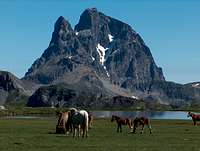
The
Anayet-Ossau area is exceptional in the Pyrenees for a multitude of reasons, but especially its geology. Going down the pass of Pourtalet, we can see in the far right some screes with quite unusual tones: red ocher, yellow, even black, like burnt magma. For good reason ! It is the only volcanic place in the Pyrenees. The most we converge towards the
Anayet, the most slopes are littered with taunts of basalt. On the dark spots, we even find those spongy rocks, scar of a turbulent past, which one cannot find closer than before the
Auvergne in France.
The year before, I had tried to reach the
Anayet by that side through the valley of Espelunciecha, before turning back at the lake under a threatening weather. Today's hike, the western Canal Roya, provided me another opportunity by varying the route, and thus making a symbolic a junction Somport-Pourtalet. This long spiral-shaped valley requires a few hours of walk before reaching the last final corrie, where the twinkling marshy grass spread in meanders. This is only above this balcony, after a few stiff laces, that the Anayet lakes comes into sight.
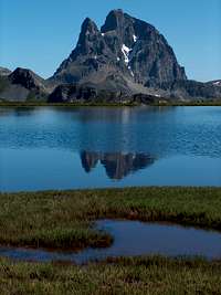
How to describe the site? In an amphitheater of mountains whose folds are as purple as the soil on which grow this "English golf course", lies nonchalantly a vast water, whose contours are torn between peat and peninsulas. Inside reflects the silhouette of the distant
Pic du Midi d'Ossau, seen here from the south, and the Peak of
Anayet: A frozen mastodon of gray lava, like a knife from underneath, which would have soaked the ground with blood. At this time of year, it is common to find a heterogeneous herd of horses and cows, wandering in this big empty space with allures of America. No other sight illustrates so much freedom.
![Anayet lake panorama]() Anayet lake panorama
Anayet lake panorama
The pass between "the
Anayets", plural because there is the "Vertice" and "Peak", is located between the latter and the culminating point of the ochre folds. Contrary to what inspires its name, "Vertice" is the least vertiginous of the two. We walked through the hollow leading up to the pass, then followed the edge of Vertice, surprisingly topped of basalt over last meters. The summit reveals the wide grassy valley of Izas, and the great limestone wall of the
Pala de Ip and the
Peña Telera. Peña
Collarada, for the day after tomorrow, also juts out from behind. What a program !
Despite our efforts, we managed to identify only one of two huts, the one in the bottom of the valley. The other, supposedly perched on a jump, remained invisible. After eating, then savantly discussed about the panorama, we chose to follow for a while the red crest, leading to Pico Royo. But uncomfortable and increasingly difficult bumps prompted us to take the shortcut directly into the valley, through wild grassy slopes.
The Izas hut waited for us as we expected, but we reserved an unpleasant surprise: with an uneven ground, littered with trash, it looked more like a pigs barn. In addition, the surrounding cattle seemed to have fallen for a deep friendship for us, which prompted us to leave as soon as we could, seeking the other hut of Vuelta de Izerias.
The Pala de Ip
![Marmot blocked in the Cabana de la Vuelta de Iserias]() The trapped marmot
The trapped marmot![Cabana de la Vuelta de Iserias]() Cabana de la Vuelta de Iserias
Cabana de la Vuelta de Iserias![Cabana de la Vuelta de Iserias]() Cabana de la Vuelta de Iserias
Cabana de la Vuelta de Iserias
While crossing the river, the ocher rocks suddenly give place to the chalky scree of the
Pala de Ip, and the trail begins in a corrie. As it orients towards the right ledge, it vanishes and reveal suddenly behind the hill a small concrete house. The location is spectacular, although the location is poor in wood and water.
Luckily, drops of water were flowing from the cliff, over which some snowfield was melting, and we wrecked a dead shrub to make a fire. Not sure the next people would have this chance! A surprise awaited for us, while pushing the metal door: a marmot was trapped inside! It must hage sneaked through the window sumarilly walled with stones, and remained trapped. After we made many portraits of it, it slipped through the door and disappeared.
![Tozal de Iserias]() Tozal de Iserias
Tozal de Iserias
We had plenty of time to follow the sunset, accompanied by the formation of fog over the
Pala de Ip. The whistling of the wind lasted all night, despite all the comfort of this simple but clean cabin. While pushing the door the next day, a boar bolted at full speed toward the path that we had to borrow. The next stage, strangely, we reserved a lake. The Ibon Saman, or Izerias, whose bottom porous is betrayed by an uncertain level, sleeps in a funnel. On the opposite side, the far end of the dry valley leads to a pass that gives access to the top of the long ridge.
Two prominences are topping the big wall of the
Pala de Ip: the
Pala de Ip itself, highest, and the "Moleta", in the West. Like its name suggest, it is cylindrical and flat, as it was put just above, and allows a spectacular ledge allows to go around. We overlook Canfranc and the whole valley. What a view!
![Chamois (Isard) of the Pyrenees]() Isard (Pyrenean chamois)
Isard (Pyrenean chamois)
The ridge which runs to the
Pala de Ip is wide, long and very impressive. Especially on the right, where the Circo de Ip appears, with its reservoir, and the dolomitic north face of the
Collarada.
The top of the
Pala de Ip breaks the uniformity of the ridge, and we need to place our hands while we pass a narrow step, before the attack on more welcoming the southern slope . I suddenly realize that below us is the wall as we had seen since the
Anayet. In other words, 500m of drop ! But the worse comes at we finish the climb, and find a hiker, with his dog, a fat german shepherd, who just passed there before !
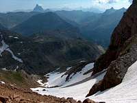
![Circo de Ip]() Circo de Ip
Circo de Ip![Chamois (Isard) of the Pyrenees]() Valley of Ip
Valley of Ip
Hard to say which of the two promineces is the real top of the
Pala de Ip, so we went to both. But the east one justifies well the visit, as it provides a superb view to the the steep pinnacle of
Punta Escarra, and the Campanal d'Izas at the very bottom of the valley. In the distance, a whole range of peaks: the
Pic du Midi d'Ossau, the
Balaïtous, greyish through a heavy atmosphere.
During the afternoon, far from being complete, we considered for a moment the mad project to climb
Collarada in the same day, via its steep rocky north gully, leaving temporarily our bags in the Circo de Ip. But the sight of the first Cumulus, and then heavy legs, finally made us change our opinion. Then we descended into the circus Ip, temporarily disrupting a huge traffic of sheep, that the Aragonese shepherd and his two dogs strove to collect.
Here, we abandoned the idea to bivouac: none of the countless ruined buildings of the former power station made an inviting place to spend a night. Then, we walked down the Ip valley, passing a huge ravine with cliffs in the middle, worth seeing too.
![Valley of Ip]() Valley of Ip
Valley of Ip
I can not conclude this section without being shocked by the state in which was left this remarkable natural site. In addition to these four buildings rotting on the spot, broken tiles, metal sheets flapping in the wind, ripped roofs, the area is also littered with various debris over few hectares: electric coils, cans, pipes, pieces of rope. Besides those of non-identifiable, but certainly not very biodegradable (should we say dangerous?). Let's finally add that stupidity attracts stupidity: some corners are filled with garbage bags, broken bottles, cans and so on. According to some news (but not so new anymore !), a restoration project seems to be under study, about the main building, certainly the least ugly, to make a mountain-hut. Let's hope the covers the costs for rehabilitating the site will not cancel the project ...
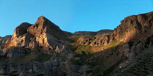
The Peña Collarada
![Collarada]() Karstic plateaux
Karstic plateaux![Collarada]() Flowery meadows
Flowery meadows
Since we decided to return to our quarters, the Camping Municipal de Lescun, the Peña
Collarada would be the goal of a day-hike only. Another reason to return was that a friend of Olivier joined too. The steep corridor on the north face that we saw the day before, and climbing again the long valley of Ip, didn't inspire us much. Therefore we decided to use the south route.
This has two disadvantages, rather contradictory: While it would be better to leave early, at dawn, not to suffer under a blazing sun, it is mandatory to go before to the Town-Hall of Villanueva, to obtain an authorization to drive on the track. The ban is far to be theoretical: the land rovers of the Guardia Civil are not an uncommon sight in this region, to distribute fines ! But here we are, it's Spain ...
So we were all waiting at 8:45 in the cobbled street of the centre of Villanueva, before the closed door. Only 9:10 after the bell had finished ringing, a municipal employee, apparently there for a long time before, opened ! After a crazy drive that looked like the rallye of Cyprus, the handbrake was finally squeezed in the hairpin of the track near the "Mirador", at 10am. The race against the clock, or rather against a probable storm late afternoon, could begin. We went on the path, which after passing two huts, slipped into a ravine. We left pastures increasingly scattered, through a karst scenery more and more naked, similar to Arres of
Anie, or even worse, the
Cotiella.
The route we had chosen for the climb was the easternmost, the one that is overlooked by the Colladaretta, this secondary top resembling so much to the
Collarada. We arrived at the foot of a small cliff where a delicate step allowed to move to the next floor. We had already well started our water supplies, and took a break to fill the bottles. Alternately, we adopted an acrobatic pose, in order to get into the bottle neck the drops of water trickling from a resurgence of the wall. The operation lasted several tens of minutes. A delicious mint flavor emerged from some leaves accidentally trampled, where the drops crashed. How to better describe the Spanish Pyrenees than with this smell, mingled with that from thorny bushed and flint, ubiquitous in arid chaos?
![Lago de Ip]() Circo de Ip from the top
Circo de Ip from the top![Natural arch from the top of the Collarada]() Natural arch
Natural arch![Lago de Ip]() Circo de Ip
Circo de Ip![From the Collarada, looking west]() Karstic wilderness
Karstic wilderness![On the way down from the Collarada]() On the way down
On the way down
We emerged on a last grassy lawn, then walked a hollow containing a wide snowplate. A severe walk up followed through unstable yellow-orange screes, which led to the pass overlooking the Circo de Ip, exactly at the top end of the Northern Corridor seen the day before. We finally followed the ridge, in a grueling heat, to reach the summit. At 2883 m, it is one of the highest in the region, and offers views commanding all this region of the High Aragon, sometimes nicknamed "the Pyrenean Dolomites". Just take a look at the perspective under our eyes, from east to west:
Tendereña,
Peña Telera,
Collarada,
Pic d'Aspe, successively, like teeth chiseled on this gigantic wave petrified limestone. It can also be easily recognized on satellite photos.
Fantasy of nature, below the summit in the west: somewhere in the middle of this chaos of limestone strata, surprisingly stands a natural arch. We notice it from the "other" top of the
Collarada (as its etymology indicates a twin peak). Since the sky was still quite unloaded, a lucky weather by such temperatures, we decided to get out of there by the western variant. A final descent into the debris landed us on a vast plateau, at the end of which, far away, stood a hut. But we went left to the bottom of a starting ravine, which as the topo indicated, was the one that would bring us back safely. The pines and more vegetation, reappeared, highly welcomed as the sun began to be very heavy. The descent, sometimes sparsely marked with cairns, cleverly slipped through the maze. Then we found back the track, going down to the place we parked the vehicle.
As we drove back to Villanueva on the track, the heavily loaded Peugeot 106 of Olivier hit some prominent stone on the track, and eventually lost the back bumper, which we noticed in the rear mirror ! Don't worry, it's fine, shouted Olivier, as he ran back to the car, this huge piece of plastic in the hand, and packing it hastily in the boot, while we were all quite embarassed of the damage that happened to the car of our generous friend. We drove back to France until Lescun, where was my tent in the campsite as well as Olivier's parents in some guesthouse, while Philippe drove back to Toulouse : some work to do the day after. Here ends our team-trip. I have made a couple of other walks with Philippe since then but unfortunately not with Olivier.
Epilog and Conclusion
![Lago de Tortiellas]() Lago de Tortiellas
Lago de Tortiellas
This is the
Pic d'Aspe, glimpsed the day before, to which I decided to end my stay, alone. No more hikes after but a wedding party some 500km away !
Just like for the foggy Ansabère and my attempt at the Castillo de Acher interrupted by rain, the weather decided otherwise, granting only the morning again. No matter, the day-hike had already started very dumb: I just had forgotten my map in the car, and realized it after having reached a significant height, and significant orientation mistake as well: I was climbing the wrong peak !
![Trumpet Gentians (or stemless gentians)]() Trumpet Gentians
Trumpet Gentians![Flowers in the Pyrenees]() Blue gentians
Blue gentians![Flowers in the Pyrenees]() Espelunciecha valley. RIP.
Espelunciecha valley. RIP.![Espelunciecha valley (not existing anymore). RIP.]() Espelunciecha valley. RIP.
Espelunciecha valley. RIP.
That was enough to have previously walked the most uninteresting half that was the major work-site of the Candanchu winter resort, to be extended. Everything is tracks, surfaced slopes and embankments, freshly grown out of the ground, as seeming to defy the laws of erosion. A question arises inside me: how far, by what means, and until which cost ? These scars inspire me even more pain than the lavas of former
Anayet volcano, yet arisen with so much more violence few million years ago...
But still, Candanchu is not the worst: the Espelunciecha Valley, on the other side of the
Anayet massif, under the Pourtalet pass, the one I had walked the year before, for first attempt, simply no longer exists. Devoured by the ogre of the Formigal winter resort. What is the goal of Aramon, the holding company that manages the two stations ? We must face the facts: Despite rumors and denials of all kinds, it is the site of the Anayet lakes marshes thatwhich separates the two.
Do we have the right to transform the mountain at our option, just under the pretext that the offer meets demand ? The advocates of skiing will say yes : if the mountain is not reserved exclusively for skiers, neither it is not the hiker, although a less profitable a kind of consumer. And it is well known that any area affected by any potential development has the annoying habit of becoming the most wonderful in the world just the evening before works start.
But should not we not question the legitimacy of such an enterprise, in a portion of the range which is not famous for its snow, what's more located on the southern slopes, while the Pyrenees themselves fully bear the brunt of global warming ?
History has often shown that changes inflicted to the nature by men, especially those made in haste and without consultation, are irreversible. The Circo de Ip witness it in a lower scale, as well as many others. But the gigantism of the Formigal project is unprecedented. Do the Pyrenees deserve such a scar ? More than an ode to the beauty industry
Anayet-Ip, this story is a scream of pain...
![Sad, sad, sad....]() Bienvenidos a España
Bienvenidos a España


Comments
Post a Comment