
|
|
Area/Range |
|---|---|
|
|
36.24600°N / 116.842°W |
|
|
Hiking, Mountaineering, Bouldering, Scrambling, Canyoneering |
|
|
Spring, Summer, Fall, Winter |
|
|
Overview
Death Valley, at about 3.4 million acres, is the largest National Park in the Lower 48 States. It is a huge area with stunning contrasts. It is unique in that it contains the hottest, dryest, and one of the lowest locations in the Western Hemisphere. This is of course Badwater, which is 282 feet below sea level. The park also contains numerous high mountain peaks, including Telescope Peak at over 11,000 feet.
Death Valley was named by gold-seekers, some of whom died crossing the valley during the 1849 California gold rush.
These were my thoughts that I recorded in my journal when I visited Death Valley for the first time back in January 1998:
"Intersecting alluvial fans. Interwoven parabolic dunes. Dry washes interrupted with greasewood. Brilliant blue sky meeting deeply slashed tan mountains. Alkaline deposits spread wide on the valley floor. The rolling dark road goes on and on down the length of the valley to its terminus. Everything's big, huge, grand. Attempts to single out one feature are lost. As I photograph, my eyes are drawn again and again away from the small features that I could easily capture on film, to those that I could never do justice to. What is so special about Death Valley is the overwhelming effect of its vastness. The harsh light making the pastel hues of land contrast with the stark sky. The endless canyons framing their contents: tarantula and coyote, roadrunner and rock, fence and footprint."

Devil's Cornfield
There are many trails to hike, places of cultural significance to visit, and seemingly endless rugged wilderness to explore in Death Valley. 95% of the park is designated wilderness. In the springtime the weather is mild and wildflowers may carpet some areas when the winter rains have been good. In the summertime temperatures are hot hot hot! Fall and winter are popular times to visit Death Valley.
Also, be sure to visit the National Park Service Website!
Getting There
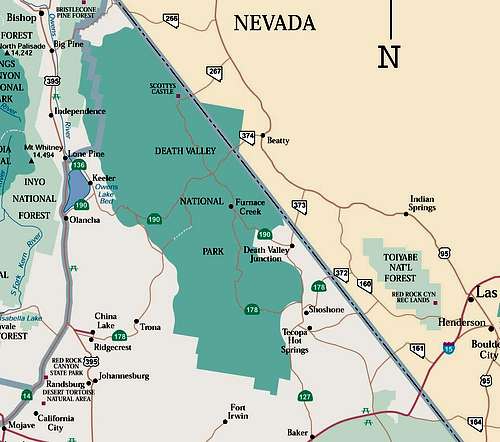
You can get to Death Valley from the east in Nevada via U.S. Route 95 with connecting highways at Scotty's Junction (State Route 267), Beatty (State Route 374), and Lathrop Wells (State Route 373).
From the south, I-15 passes through Baker, California on its way from Los Angeles to Las Vegas. State Route 127 travels north from Baker to Shoshone and Death Valley Junction.
From the west take Hwy 178 (at Ridgecrest), 190 (at Olancha), or Hwy 136 (at Lone Pine) from Hwy 395. Going Hwy 136 allows you to make a very worthwhile stop at the brand spankin new Interagency Visitor Center which is on the intersection of Hwy 395 and 136. There is also a beautiful view of Mt. Whitney from here.
Visit Death Valley with a full tank of gas - gas is available at Furnace Creek but for a hefty price!

Lonely Road in Death Valley
Road Conditions
Death Valley Morning Report
Download a more detailed map of Death Valley
Red Tape
There is a $30 fee charged for entrance into Death Valley National Park. This fee will get you a pass good for 7-days. You can also buy an $80 America the Beautiful Federal Lands Recreation Pass good for entrance to all National Parks, National Forests, BLM, US Fish & Wildlife, and Bureau of Reclamation sites for one year from the date of purchase. If you're disabled, you may want to get an Access Pass which is free and good for a lifetime. If you're 62 years of age or older, a Senior Pass can be purchased for $10 and they're also good for a lifetime. Click here for more info on fees and passes.
No permits are required for day hiking or backpacking but check-in at the Furnace Creek Visitor Center and fill out a voluntary permit and let someone you trust know of your plans!
Folks must camp in legal camping locations. The National Park Service recently (in 2021) updated the Death Valley Park website Backcountry Camping - Death Valley National Park (U.S. National Park Service) (nps.gov) which shows where you can backcountry camp, if you choose to sleep in your car, or if you choose to backpack. You need to camp in the backcountry wilderness as indicated on the wilderness map. If you plan on camping in the backcountry, make sure you do it in a legal camping location.
Many of the springs in Death Valley are either dry or have been contaminated by burros, so do not rely on them. Do not camp in drainages or washes.
Camping & Lodging
Death Valley Camping Info
Death Valley Lodging
Highlights
Here are just a few favorite highlights of Death Valley National Park...
The 7-mile hike to Telescope Peak begins at 8,133 feet and crests at 11,049 feet. On the way you'll pass through pinyon and limber pine forests and ancient bristlecone pines near the summit. The view from the top is spectacular as you can see Badwater (the lowest point in the Western Hemisphere) and Mt. Whitney (the highest point in the Lower 48).
Badwater has a newly constructed boardwalk that leads you out towards the lowest point. This is a must-see if you've never been there before. I always get a chuckle of looking up at the cliff high above Badwater and seeing the sign way up there saying, "Sea Level."
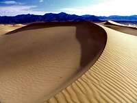
Near Stovepipe Wells are the often photographed dunes of Death Valley. There are no designated trails here and one can spend as little as an hour to as long as all day exploring the dunes.
It takes a while to get to the Racetrack but here is another often photographed area of Death Valley that's worth the drive to get to. Here, during high wind periods, there are rocks that "sail" their way across a dry lake bed. When you see the rocks later on they appear to have moved on their own accord and have left a path.
Scotty's Castle is a worthwhile stop. Take the tour and be entertained by costumed interpreters who take on the personas of Scotty and his friends. Hike to the top of the hill behind the castle to see Scotty's grave. I like his epitaph, "I've got a few things to live by: Don't say anything that will hurt anybody. Don't give advice - nodbody will take it anyway. Don't complain. Don't explain."

Mojave Aster
My favorite time of year in Death Valley is springtime, usually late February to early March, when the flowers are blooming! The spring of 2005 was especially wonderful. In the southern part of the park near Ashford Mill the desert sunflowers or desert gold often cover the hills in bright yellow blooms.
CA Desert Wildflowers Album
March 2005 Death Valley Trip Report
Suggested Books and Maps
Hiking California's Desert Parks by Bill Cunningham (Falcon Press)
Desert Summits: A Climbing & Hiking Guide to California and Southern Nevada by Andy Zdon
Tom Harrison's Death Valley National Park Map
Etc.
Pets
Pets must be leashed or confined at all times. Owners are responsible for picking up animal litter and depositing it in proper trash receptacles. Pets are not allowed in the open backcountry, the Visitor Center, or other public buildings. There are some exceptions to these rules so be sure to check with the rangers for up-to-date information.
Safety Precautions
Never travel alone. Always tell someone where you are going and when you plan to return.
Be alert for flash floods when it looks stormy. Do not ford low places when water is running. Floodwaters can undercut pavement or sweep a car from the road.
Abandoned mines can be dangerous. Do not explore them without assurance they are safe. Forgotten caches of explosives are sometimes found; do not touch them, but report them to park rangers immediately. Vertical shafts are invisible from within dark tunnels, and wooden supports can give way at any time, both of which could be fatal.
Carry plenty of water -- one gallon per day per person -- and drink it!
Wear comfortable, sturdy footwear and a hat; use sunscreen.
If your vehicle breaks down, stay with it. It is much easier to find a vehicle than a wandering person.
For more info
Death Valley National Park
PO Box 579
Death Valley, CA 92328-0579
(760) 786-3200 Phone
(760) 786-3283 Fax
Designations
Proclaimed a National Monument Feb. 11, 1933
Redesignated a National Park Oct. 31, 1994
Designated a Biosphere Reserve 1984
External Links
Sand Dunes in Death Valley
Death Valley Hiking Page
Death Valley Weather Forecast
Death Valley Climate Info
Death Valley Natural Features and Ecosystems
Death Valley Plants
Death Valley Animals
Noondueler - Dec 19, 2009 2:32 pm - Voted 10/10
SuggestionIt would be good to include "national park" in the title to this page since that is what you are covering here. Happy holidays. ND
Cedar - Apr 8, 2010 6:07 pm - Voted 10/10
CorrectionBadwater is actually the second lowest point in the western hemisphere after Laguna del Carbon in Argentina at -344 feet in elevation. This correction applies to the first paragraph and the "Highlights" section.