
|
|
Area/Range |
|---|---|
|
|
37.63440°N / 118.2547°W |
|
|
Hiking |
|
|
Spring, Summer, Fall, Winter |
|
|
Overview
The Inyo-White Mountains is a beautiful, desert range that trends north-to-south while running parallel to the fabulous Sierra Nevada of California. The range is split in half by highway 168 as it crosses over Westgard Pass outside of Big Pine, California. Those mountains north of Westgard Pass are known as the White Mountains, while those to the south of the pass are known as the Inyo Mountains.Comprised of many high peaks, including the 3rd highest peak in California, White Mountain, and the highest peak in Nevada, Boundary Peak, the range is bordered on the west by the Owens Valley and on the north by highway 6 near the California/Nevada border. The White Mountains’ eastern border is Fish Lake Valley.
At the southern tip of the Inyo Mountains, highway 190 runs between the Owens Valley and Death Valley National Park. Saline Valley (and the outer limits of the Death Valley National Park badlands) makes up the eastern border of the Inyos.
Although residing largely in California, two of the range’s named peaks, Boundary Peak and Mustang Mountain, lie just inside the Nevada border.
The Inyo-White Mountains resides hugely within the Inyo National Forest. The northern portion of the White Mountains also contains the Boundary Peak Wilderness. Additionally, the range hosts a couple of established natural areas and research areas, most notably, a high-altitude research station at Barcroft Laboratory, above the 12,000-foot level in the White Mountains. Some of the station’s equipment sits at over 14,000 feet atop White Mountain itself.

Named Peaks of the Inyo-Whites
Named peaks in the Inyo-White Mountains include (north-to-south):Whites –
-Mustang Mountain (9,869 feet at Mustang Point)
-Boundary Peak (13,140 feet)
-Montgomery Peak (13,441 feet)
-The Jumpoff (13,484 feet)
-Mt. Dubois (13,559 feet)
-Mt. Hogue (12,751 feet)
-Indian Peak (11,297 feet)
-Headley Peak (12,676 feet)
-White Mountain (14,246 feet)
-Mt. Barcroft (13,040 feet)
-Piute Mountain (12,564 feet)
-Sheep Mountain (12497 feet)
-Campito Mountain (11,543 feet)
-County Line Hill (11,229 feet)
-Blanco Mountain (11,278 feet)
-Black Mountain (9,083 feet)
Inyos –
-Andrews Mountain 9,460 feet)
-Squaw Peak (10,358 feet)
-Waucoba Mountain (11,123 feet)
-Mazourka Peak (9,410)
-Winnedumah Paiute Monument (8,369 feet)
-Mt. Inyo (11,107 feet)
-Keynot Peak (11,101 feet)
-New York Butte (10,668 feet)
-Pleasant Point (9,690 feet)
-Cerro Gordo Peak (9,184 feet)
-Conglomerate Mesa (7,707 feet)
-Malpais Mesa (7,731 feet)
Getting There
Parts of the range have paved highway access, others have maintained dirt roads, while still others require 4WD
I'd suggest exploring the individual mountain pages (or Zdon's guidebook, which is mentioned below) to obtain specific information on accessing the spots you're interested in.
Getting into the Mountains
Although Boundary Peak, Montgomery Peak, and White Mountain receive plenty of visitation, the other peaks in the range receive very little traffic. The range is a surreal spot, begging for exploration.I’d recommend Andy Zdon’s classic desert hiking guidebook ‘Desert Summits’ to supplement the Inyo-White peakbagging information that can be gathered from SP.
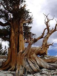
Bristlecones
If peakbagging is not an interest, one might find enjoyment in visiting the many fine bristlecone pine groves located throughout the range. Two of the groves, Schulman Grove and Patriarch Grove, located in the White Mountains, offer maintained trails and interpretive signage to help visitors learn the story of these ancient trees. The Schulman and Patriarch groves can found off of White Mountain Road, which runs north along the spine of the range off of highway 168 near Westgard Pass.
Camping
I'd suggest exploring the individual mountain pages (or Zdon's guidebook, which is mentioned above) to obtain specific information on camping in the areas within the range that you're interested in.
Noondueler - Dec 12, 2009 1:08 pm - Voted 10/10
Pleasant Point M&RJust added it to the page. It's on the DPS list of peaks. You might want to add it to the Inyo list on the page. Have a super holiday! ND
cp0915 - Dec 14, 2009 10:08 am - Hasn't voted
Re: Pleasant Point M&RAdded. Thanks!
Noondueler - Dec 26, 2009 3:46 pm - Voted 10/10
Cerro Gordo Peak M&RJust added it to the page. Happy New Year! ND
cp0915 - Jan 4, 2010 10:08 am - Hasn't voted
Re: Cerro Gordo Peak M&RThank you, brother. To you as well!
Noondueler - Feb 15, 2010 4:08 pm - Voted 10/10
Mazourka Peak M&RHas been added to the page. Later dude!
cp0915 - Feb 16, 2010 9:58 am - Hasn't voted
Re: Mazourka Peak M&RSweet. Linked!
Noondueler - Oct 24, 2010 4:57 pm - Voted 10/10
Added Blanco Mtn.Good day Sir!
cp0915 - Oct 25, 2010 10:39 am - Hasn't voted
Re: Added Blanco Mtn.Got it. Thank you, sir.
Noondueler - Dec 12, 2011 6:50 pm - Voted 10/10
Chocolate Mountain M&RJust added a page for Chocolate Mtn northeast Inyos