

|
|
Area/Range |
|---|---|
|
|
50.48405°N / 16.34148°E |
|
|
Hiking, Sport Climbing, Toprope, Bouldering |
|
|
Spring, Summer, Fall, Winter |
|
|
3025 ft / 922 m |
|
|
Overview
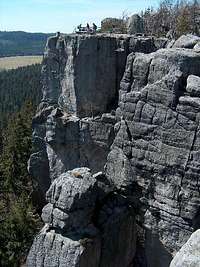
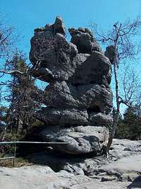
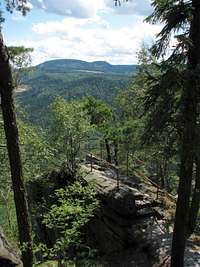
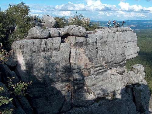
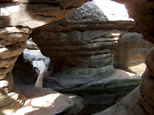
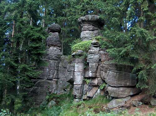
| Góry Stołowe (literally the Table Mountains), is a two-tier sandstone tableland in Poland - the highest within a wider set of sandstone plateaux and cuestas sitting in the middle of the Central Sudetes and extending further northwest into the Czech Republic. It contains a couple of fabulous "rock labyrinths". Its highest summit is Szczeliniec Wielki at 922 m (Czech name: Velká Hejšovina; German name: Große Heuscheuer). In Poland, this kind of landscape is absolutely unique. Apart from the fact that they stand in Poland, the Stołowe Mountains differ from their Czech neighbors in shape and allure. While their Czech extension, the Broumovské stěny, forms a cuesta, whose rock layers are gently inclined, and the Adršpašské skály are heavily dissected by tributaries of the Metuje River and run-off channels, which tends to shape a landscape resembling a forest of tall, upright stone monoliths, the sandstone layers of the Stołowe Mountains lie horizontally plus they have been much less eroded by flowing water. This results in a vast plateau - with cliffs along its northern and southern edges - over which the remnants of a younger sandstone tier is superimposed, forming the massifs of Szczeliniec Wielki (922 m) and Skalniak (920 m). Szczeliniec Wielki is a classic mesa, whose German name, Große Heuscheuer, literally means Great Hay Barn.  Szczeliniec Wielki ("Great": left) & Mały ("Little": right) Szczeliniec Wielki ("Great": left) & Mały ("Little": right)The sandstones forming Góry Stołowe are heavily jointed, i.e. cracked by thousands of fissures, narrow or quite wide, depending on the place. The east terraces of Szczeliniec Wielki, overlooking the Kłodzko plain, perfectly illustrate that. On the summit of Szczeliniec Wielki and at the northwestern end of the massif of Skalniak are the two top attractions of Góry Stołowe: the rock labyrinths. Both are nature reserves. In the latter, called Błędne Skały ("Misleading Rocks"), the cracks - shaped by rain water and weathering - run almost like tunnels below the uppermost layer of rock. (More on the top attractions in chapter 3.)
Błędne Skały (3 km west of the village of Karłów) and Szczeliniec Wielki (just north of Karłów) are not the only attractions of the Stołowe Mountains. Among other groups of sandstone tors worth seeing are Skalne Grzyby (i.e. "Rock Mushrooms", over 5 km east of Karłów and just south-west of the village of Wambierzyce, a pilgrimage site) and Białe Skały (south of Karłów). A very interesting hill is Szczeliniec Mały, however, it is a strictly protected nature reserve to which there is no entry. A fairly interesting summit is Narożnik. There are also the ruins of Karl's Fort. Apart from all the rocky outcrops, most of the area - the top of the lower tier of the sandstone tableland at about 700 m, covered with impermeable marl - is rather flat, and hosts peat-bog ecosystems, like the Batorów peat-bogs. Those bogs were heavily drained in the 19th century, but now some of them are slowly being restored.
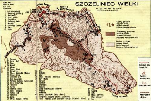
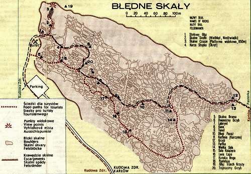
Unfortunately, Błędne Skały and Szczeliniec Wielki are very popular destinations for day trips during sunny weekends. People tend to visit both on the same trip to the mountains. For both Błędne Skały and Szczeliniec Wielki, there is an entrance fee, and visitors are obliged to follow a circuit that is defined with marking, and done clockwise, in order to avoid traffic jams. Queues are often encountered at the entrance when starting too late in the day, and as for Błędne Skały, the tiny road leading to the car park is too narrow, so vehicles are allowed to go up and down alternately every 15 minutes! To fully enjoy your visit, come early, possibly on a week day and off season, or when the weather is cold (but when there is not much show - then the labyrinths are inaccessible). Or visit the other rock formations mentioned above, where there are no crowds. 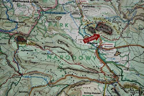 Map with Błędne Skały and Szczeliniec Wielki Map with Błędne Skały and Szczeliniec Wielki |


Getting there
| The village of Karłów - founded by Charles VI Habsburg as Karlsberg - is the hub for the visitors of the national park. Karłów is best reached via Kłodzko from Poland, or Nachod from the Czech Republic. In the summer season there is a bus service between Kłodzko and Karłów. (Off season the bus only goes as far as Radków.) Kłodzko has bus and rail links to the city of Wrocław. Agrandir le plan |
Top Attractions
| The trail which leads from the foot of Szczeliniec Wielki to its top is actually a gigantic stairway. Its over six hundred stone steps were laid by Franz Pabel (text in Polish) at the beginning of the 19th century. Franz Pabel is believed to have become the first (in the world, or at least in Europe) licensed mountain guide: More on National Park's site. The rock maze of Błędne Skały sits at the northwest end of the massif of Skalniak, which is - except Błędne Skały - much less interesting than the massif of Szczeliniec Wielki. Błędne Skały - unlike Szczeliniec Wielki - don't offer spectacular views, but their rock labyrinth is even better developed and more sophisticated, with fine forms of "pseudokarst" to be seen.
|


Red Tape
The area is a national park: Park Narodowy Gór Stołowych. Hiking is only allowed along the waymarked trails and roads.
 Away from the top attractions
As for rock-climbing, climbers are often seen on the vertical walls below the east balcony of Szczeliniec Wielki where a few dozen routes exist, but one must have a club license, observe some special rules, and fees have to be paid too. A map here shows the areas where rock climbing is - at least in theory - permitted (more info on this topic will be appreciated).
Maps & Weather
A good paper/waterproof/digital 1:30,000 map, which also covers nearly all of the Broumovské stěny, can be purchased here.
- AccuWeather forecast for Karłów
- meteocentrum (Czech)
Camping and Accommodation

Camping is forbidden except at the campsites which are in the nearby villages, such as Karłów or Radków, where there are also a number of guesthouses. There are two mountain huts in the area: Pasterka (with a small campsite: an equivalent of €4.5 per person in 2020) on the fringe of the village of Pasterka and a hut on the very top of Szczeliniec Wielki.