
-
 4333 Hits
-
 83.1% Score
-
 16 Votes
|
|
Route |
|---|---|
|
|
45.97964°N / 6.87143°E |
|
|
Sport Climbing |
|
|
Summer |
|
|
Half a day |
|
|
D sup., French 6a |
|
|
8 |
|
|
Overview
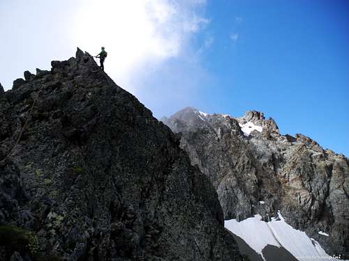
Gaspard Premier
On the sunny South face of Pointe Gaspard the fine route Gaspard Premier, now quite a classic notwithstanding it has been recently climbed, offers a technical climb on first class gneiss, leading to this beautiful tiny summit. The climbing is not continuous (only a short 6a move), satisfactory and various on slabs, cracks and little walls. The views over Mont Blanc group are unforgettable.
Getting There
The starting point is the town of Chamonix-Mont Blanc m. 1087.
Main road access to Chamonix Mont Blanc
- From Aosta Valley (Italy) - Follow the E25 Motorway towards Courmayeur, then the Mont Blanc Tunnel to Chamonix (65 km. from Aosta)
- From Martigny (Switzerland) - Follow the road leading to the Switzerland – France border, then to the village of Argentiere and to Chamonix (45 km. from Martigny, 13 km. from the border)
- From Geneve (Switzerland) - Follow the E25 Motorway to St. Gervais les Bains, then the RN 205 to Chamonix
Most of the range can be easily accessed by the Flégère and Brévent lifts directly from Les Praz (Flégère) and Chamonix (Brévent). More information here: BREVENT-LA FLEGERE
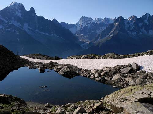
Small alpine lake - Dru and Grandes Jorasses in the background
Approach
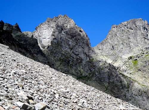
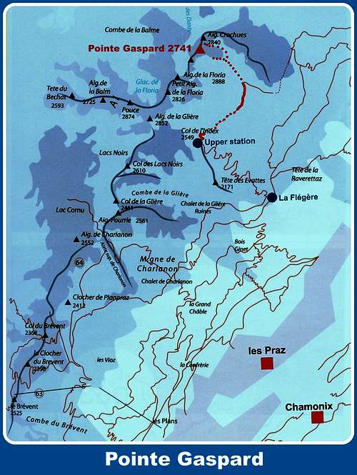
From Chamonix Mont-Blanc head towards NE and reach the village of Les Praz (3 km. from Chamonix). Take the cable-car to “La Flegere”, then the Index chair-lift. From the Index lift station follow towards right (North) the nice trail towards the Col des Crochues, skirting the Grande Floria. The views over the Aiguilles de Chamonix and Mont Blanc are breathtaking. Cross a scree - or a snow fields in early summer - walking towards the Col des Crochues, lying between Pointe Gaspard on the left and Aiguille des Crochues on the right. Rise on a few hairpins on the main trail, when getting to the level of the bottom of Pointe Gaspard spurn leave it and follow on the left a poor trail skirting the face and leading to the starting point of the various routes. 40 minutes from the Index station.
Route Description
Gaspard Premier (Pointe Gaspard)
Summit altitude: m. 2741
Difficulty: D sup., F6a max
Equipment: pegs and bolts
Climbing length: 200 m
Exposure: South
First ascent: S. Ravanel 12-9-2001
Starting point: Index chair-lift upper station (Les Praz, Chamonix Mont Blanc).
Route report (French scale)
From the Index lift station follow towards right (North) the nice trail towards the Col des Crochues, skirting the Grande Floria. The views over the Aiguilles de Chamonix and Mont Blanc are breathtaking. Cross a scree - or a snow fields in early summer - walking towards the Col des Crochues, lying between Pointe Gaspard on the left and Aiguille des Crochues on the right. Rise on a few hairpins on the main trail, when getting to the level of the bottom of Pointe Gaspard spurn leave it and follow on the left a poor trail skirting the face and leading to the starting point of the various routes. The route is the first you find when skirting the rocks. 40 minutes from the Index station.

|

|
P1 – Climb a slabby spur heading left. 4b
P2 – Climb another slab, then a steeper wall to a belay under a fine corner-crack slanting left. 4c
P3 – Climb the fine corner-crack and exit on easier rocks. 5b
P4 – On easy ground find a ridge heading towards a steep wall.
P5 – Climb the edge of the wall, then a slab slanting left and a spur to a belay on the ridge. 5b
P6 – Climb directly a superb steep wall - crux (6a or 5b with 1 aid point), then slanting left. 6a, 5b
P7 – Climb slanting right, then exit on the summit ridge and traverse left to a notch. 4b
P8 – On easier ground to the tiny summit.

Descent: from the summit downclimb on easy terrain (max UIAA III) - or make one abseil - along the North East ridge, getting the Col des Crochues between Pointe Gaspard and Aiguille des Crochues. Scramble down the gully on the East side, at first with easy climb (max UIAA I-II), then walking on a scree or a snow slope (in early summer) getting the base of the route and the approach path.
Essential Gear
Rope 2x50 m, helmet, nuts 4-9, some friends, 12 quickdraws, slings
Red Tape
The chain of Aiguilles Rouges has been inserted since 1974 inside the Rèserve Naturelle des Aiguilles Rouges. No particulary restrictions in climbing and hiking. Free camping is not allowed.
When to climb
Best season goes from middle June to the end of September.
Meteo
Where to stay
Chamonix is a primary touristic destination. Hotels, huts, gites, renting rooms. Numberless campings are situated in the Northern and Southern ends of the town.
Main campsites:
- Camping la Mer de Glace, Les Praz (3 km. North to Chamonix) +33(0)450534403
- Camping les Deux Glaciers, Les Bossons (3 km. South to Chamonix) +33(0)450531584
- Camping les Arolles, close to the centre of Chamonix - +33(0)450531430
- Camping les Cimes, Les Bossons (3 km. South to Chamonix) +33(0)450535893
- Camping Glacier d'Argentière, Argentière (8 km. North to Chamonix) +33(0)450541736
- Camping les Marmottes, +33(0)450536124
Guidebooks and maps
 |
 |
 |
Guidebooks
“Les Aiguilles Rouges – Face au Mont Blanc” by Michel Piola –
"Monte Bianco classico & plaisir" by Marco Romelli, Edizioni Idea Montagna 2013
“Alpes Francaises du Nord” by Hervè Galley
Maps
IGN 3630 OT Chamonix 1:25.000
External Links
Chamonix Mont-Blanc
Office de la Haute Montagne
CompagnieduMontBlanc