
-
 10013 Hits
-
 79.62% Score
-
 11 Votes
|
|
Mountain/Rock |
|---|---|
|
|
47.38667°N / 11.13519°E |
|
|
Hiking |
|
|
Summer |
|
|
7766 ft / 2367 m |
|
|
Overview
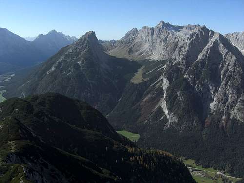
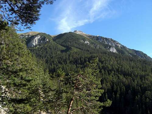
Gehrenspitze (left), Puittal and Wetterstein main range as seen from Arnplattenspitze
If you enter Leutasch valley coming from Mittenwald you will soon recognize three huge mountains bordering that valley to the northwest: Hohe Munde in the background, Öfelekopf in the foreground and between them Gehrenspitze.
Please note that there is more than one Gehrenspitze in the Alps, most notably a lower, identically named peak in the Tannheim Alps. Our Gehrenspitze is part of the Wetterstein mountain range.
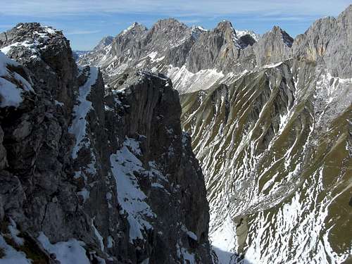
Gehrenspitze shows an impressive, huge and perpendicular north face down to Puittal, towering nearly 1300 meters above Leutasch valley ground. The east and south sides are not so steep but equal impressive with rocks faces, meadows and a huge dwarf pine zone. Gehrenspitze west ridge borders Puittal to the south and west, connected with the Wetterstein main range at Scharnitzjöchl.
Due to standing apart from the main southern ridge of the Wetterstein mountains, Gehrenspitze summit offers a spectacular view of the Wetterstein south faces such as Scharnitzspitze, Schlüsselkarspitze, Leutascher Dreitorspitze and Öfelekopf.
There are several easy hiking routes to the summit, most of them using the west ridge in the end to reach the summit cross. Gehrenspitze is well known among local hikers and guests, you will not be alone on that mountain on sunny days. Even late in the year, Gehrenspitze is one of the most frequented late autumn summits I know. Nevertheless a late October or November tour on Gehrenspitze will be not as crowded as it will be in June through September.
 Gehrenspitze as seen from Öfelekopf Gehrenspitze as seen from Öfelekopf |
 Gehrenspitze as seen from Große Arnspitze (Lukas Kunze) Gehrenspitze as seen from Große Arnspitze (Lukas Kunze) |
 Gehrenspitze as seen from Arnplattenspitze ascent Gehrenspitze as seen from Arnplattenspitze ascent |
Getting There
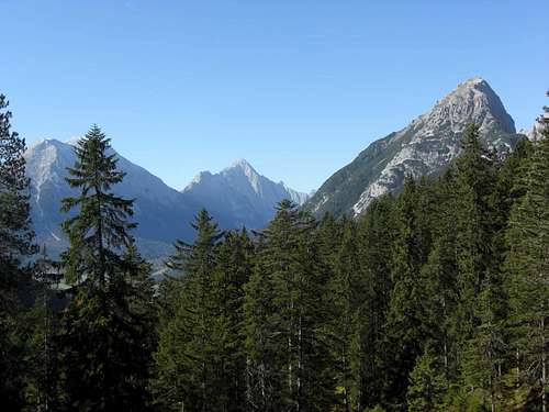
Gehrenspitze (right) as seen from Arnplattenspitze ascent with Hohe Wand
There are three trailheads for Gehrenspitze, all located within Leutasch valley:
See the map in the "Routes Overview" section for detailed information.
You reach Leutasch
Routes Overview
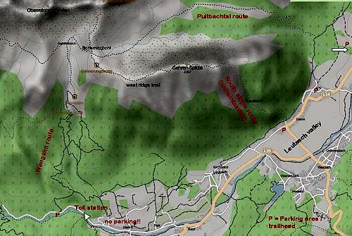 Gehrenspitze trailheads and routes
Wang Alm trail
Cross the Gaisbach toll road and ascend on a forest road in northern direction. Take the right hand forest road at a road junction. Follow that old forest road up to a new one, ascending from your right to your left. Either follow that road or take the steep forest track to your left to shortcut some switchbacks. Enter the Klammbach valley on the forest road.
Either follow the forest road up to a road junction (to the left the road goes up to Wettersteinhütte, to your right the road goes up to Wangalm)
or leave the forest road on a trail to your left before you cross the Klammbach creek (signposts for "Waldweg" to Wettersteinhütte). Follow this trail up to Wettersteinhütte and descend shortly to the above mentioned forest road junction. Follow the forest road up to Wangalm.
If you start at Leutasch – Klamm (no parking area!!) you can use marked trails and forest roads east of Klammbach valley up to Wangalm, too.
 Wettersteinhütte Wettersteinhütte |
 Memorial rock below Schüsselkarspitze Memorial rock below Schüsselkarspitze |
 Schüsselkar south cirque near Wangalm Schüsselkar south cirque near Wangalm |
At Wangalm follow the trail ascending to the south cirque below impressive Schüsselkarspitzen, there is a huge natural memorial stone for those killed in a climber accident.
Follow the trail to your left and ascend steeply up to Scharnitzjöchl.
Follow the west ridge trail of Gehrenspitze first climbing the meadow ridge in southern direction to Erinnerungshütte and to the summit rocks of Gehrenspitze then ascending south of the west ridge over scree, easy rocks and meadows to the summit.
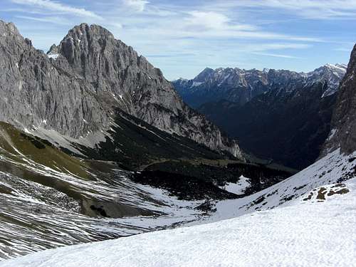
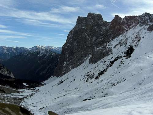
Puittal and Öfelekopf as seen from Scharnitzjöchl
Puittal route
Starting at Leutasch Lehner or Leutasch Puitbach follow the forest roads to the lower end of Puitbach hanging valley.
Arriving at Puitbach creek a trail branches off the forest roads in western direction, first zig-zagging up the steep forest slopes quite close to the Puitbach.
Once beyond the forest, you enter a beautiful Alm meadow. The trail ascends the meadows between towering Gehrenspitze north face and sun bathed south face of Leutascher Dreitorspitze and Öfelekopf. Follow the trail all the way up to Scharnitzjöchl. Turn left on the west ridge trail as described above.
 Erinnerungshütte, Wetterstein main range Erinnerungshütte, Wetterstein main range |
 Gehrenspitze west ridge Gehrenspitze west ridge |
 Gehrenspitze west ridge view to Öfelekopf Gehrenspitze west ridge view to Öfelekopf |
South slopes of Gehrenspitze
South slope route
from Leutasch-Gasse via Lehner Berg
Please note that this route is no longer maintained and marked! User aki, first author of this page, records already for 2008 that the trail has been officially closed, all markings have been painted over and trees block the path at times in the forest.
Starting at Leutasch Gasse at the rectangular bend of road number L14 follow short road in northern direction until it ends at a parking space for a nearby hotel. Turn shortly left on the forest road until you recognize a barely visible trail entering the forest to your right. There you will see some stone steps, too, leading into the forest. This is the starting point of the South slope trail.
Ascend on that trail up the forest until you enter a gully system at about 1500 m. Follow that gully until you reach the east ridge of Gehrenspitze. Along the ridge there is a cairned trail which leads directly to the summit.
Geology
Gehrenspitze Wettersteinkalk (limestone) and Puittal with the soft marlstones of Puittal zone
Gehrenspitze is not only geographically separated from all main ridges of the area. Geologically Gehrenspitze leads a separate live, too.
South of Wetterstein main ridge and north of Gaistal and Leutasch there is a chain of mostly secondary summits, separated from the main ridge by grassy cols and separated from each other by cirques and steep creek valleys.
This part is called Vorbergzug. Gehrenspitze is the main summit – and frankly said the only summit which deserves to be called a true summit – of this Vorbergzug.
Between Vorbergzug in the south, build up of Wettersteinkalk, a green algae reef limstone, and Wetterstein main ridge, consisting too of Wettersteinkalk, you will find different limestones and marls in different colours: brown, grey, green even red.
You can study these rocks around Scharnitzjöchl. These are younger sediments of jurassic age, folded to several narrow synclines and anticlines between the two Wettersteinkalk massifs and marking the limitation of two huge tectonic units of the northern limestone Alps: Lechtal nappe (Wetterstein mountains) and Inntal nappe (Mieming range).
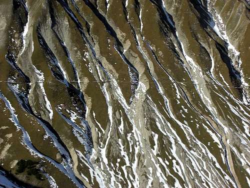
Marlstones of Puittal zone
This zone of intensely folded rocks is called Puittal zone (after Puittal valley east of Hochwanner). You will best recognise the intense red coloured Radiolarit of jurassic age, a hard stone which consists of millions and millions of monads with silica shells.
Red Tape & Accommodation
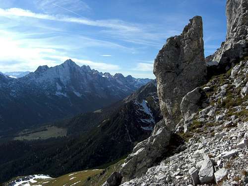
West ridge route with Mieming range
No restrictions as far as I know.
You should pay the toll road fee even if the cash point is closed (end of September), there is a pay machine at the beginning of the toll road. There are daily checkups and heavy fines!
You will find all kind of accommodation throughout Leutasch valley.
Mountain Huts
Wettersteinhütte
Wangalm
Erinnerungshütte
Gear & Mountain Condition
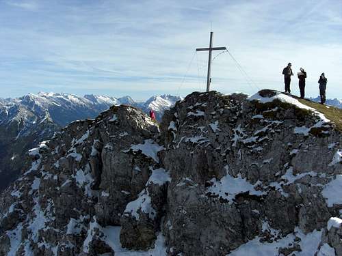
Gehrenspitze summit (19-10-2013)
Gehrenspitze is mainly a summer and autumn hiking summit.
The west ridge of Gehrenspitze has some rocks to overcome but nothing really serious.
You need normal hiking gear and good shoes for the official normal routes.
The condition of the south slope route cannot be predicted as this route is officially closed.
I did this route twice in the 1990 years; it is a steep and rather exhausting route; I will nowadays recommend the Wang Alm or the Puittal route.
Wettersteinhütte and nearby Wangalm offer food and lodging; Wettersteinhütte is open nearly the whole year round.
Current Weather for Leutasch:
Maps & Guide Books
Summit view to Wetterstein main range (19-10-2013)
Map
Alpenvereinskarte, scale 1 : 25.000
number 4/2, Wetterstein und Mieminger Berge, Mittleres Blatt
Deutscher Alpenverein
Landesamt für Vermessung und Geoinformation Bayern, scale 1:50.000, UK UK 50-50, Werdenfelser Land, Ammergebirge, 2008
Guidebook
Alpenvereinsführer Wettersteingebirge, 4th edition 1996, Bergverlag Rudolf Rother
(seen in the DAV - shop: www.dav-shop.de)
External Links
Tour description from Steinmandl.de (in German)
GPS Track for ascent from Leutasch-Gasse (not tested)