GOD FLED APPALACHIA, BUT PENNSYLVANIANS DIDN'T TAKE THE HINT
1,000 Miles of Intense Travel Through the Keystone State to Ebright Azimuth, the Highpoint of Delaware
It was midnight, but I was far from falling asleep. The cellphone alarm on my end table was set for 3 a.m. Needed rest for the drive, but was too excited. Not about climbing—there was no hiking to do—but for the travel. The escape.
You see, the road wouldn’t mention the holes in my roof and how only a lazy piece of shit would put buckets in their attic instead of fixing the puncture wounds. It wouldn’t bring up my self-inflicted conflicts with my inept coworkers, my shortcomings as a father, my health and addictions. All the road ever tells me is: “You’re fah-king great, my man. No one can get you here.”
I watched “Muana” the day before with my family and that was the impetus. From where I contracted the travel infection. “The line where the sky meets the sea…it calls me!” Muana sang. Enough with this life island I was on. Needed to leave, immediately. Just be gone for a day. A quick, 1,000-mile roadtrip to Delaware, I thought.
That state had been nagging me, as year after year I’d look at the large U.S. atlas map and think, gosh, when am I going to get this simple task done?!?! Delaware may be the easiest of all of the highpoints, but it’s a highpoint, nonetheless. Since it’s east of the Mississippi, it had to be done in winter. And there were only two weeks left in the 2017 winter.
The good thing was, the logistics for a drive-up highpoint weren’t that encompassing. Directions, food/water, cell charger, clothes, shades, piss bottle and my sleeping bag in case I needed to stop and snooze. My goal was to only spend money on gas and tolls and to never break for anything other that “experiences.”
Very rarely was I in a deep-enough slumber where the sound of the alarm became part of the dream, but it happened. In my lucid dreaming, I was on the side of a pool, forcibly holding someone’s head under water. We were struggling and I raised my head, distracted by the loud beep/beep/beep of the ringtone. Oh no, I thought, it’s 3 a.m.? I woke but was too tired. Maybe this trip wasn’t for me. Great effort was put back into falling asleep. But the infection had spread to the brain, and all I could think about was the dark solitude of the highway.
Only broke cruise control a couple of times getting out of Ohio on I-76, as it was just me and the few red circular taillights of the semis. My two-year-old “arctic blue” Nissan Rogue was still a filly, approaching 50K miles and she was looking forward to running.
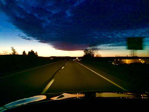
![Chasing the Rising Sun, Eastern Pennsylvania]() Chasing the Rising Sun, Western Pennsylvania
Chasing the Rising Sun, Western Pennsylvania Thankfully, I researched toll costs on I-76 before departure. It was going to be over $40, one way! Might as well fly Cleveland to Philly on a discount airline for $99 and rent a car when you take into account the tolls and gas associated with driving. We pay taxes for roads yet still get screwed.
Fortunately, before I-76 had a chance to extort you, there was a split with I-80, which ran directly through the middle of Pennsylvania, only adding 45mins to the trip.
There were some nice little rivers and foothills and slow turns around man-made cut-throughs in the rock as you approached the Appalachian Mountains heading east along I-80. A satisfying scene but the people and culture as a whole were quite disgusting. Too harsh?
Halliburton made billions fracking the area and the greedy clueless land owners were happy to sell—who cares if my neighbor’s drinking water is flammable and if the streams are poisonous, I crave currency; I can sellout and move. Instead of focusing on cleaner, renewable options, the simple human continues to be a slave to the dependencies the oil and gas corporations perpetuate.
I-80 through Pennsylvania is also the Midwest’s version of the Bible Belt. Every billboard was a reminder that the Sun God would punish you if you didn’t do a human sacrifice, or something like that. “In the wastelands of America, what else do you have, but god?” my cousin Dusty asked one time.
At exit 161, I was finally freed from the interstate, and headed southeast at a diagonal toward Harrisburg. Look, there’s Penn State! Remember how that that one dude fucked a bunch of little kids, everyone knew and nothing was done because he was associated with the football team? Five years is enough time to forget. Ask Mel Gibson and Sean Penn. Penn State went to the Rose Bowl this year. Ahahahahahahahahahahahahahhaahhaahha.
The two-laned road and cruise past Pleasant Gap, and when I was in the middle of Centre Town, I took a sharp left on T-437. Wanted to see the real heart of Pennsylvania and found it miles later on the unpaved Indian Road. Desolate farms on both sides so damp with misguided tradition the mold grew on the fence posts. You ever see what years of smoking does to a heart? I was the surgeon looking down at disease on the operating table. The heart was beating, but at such a slow rate no significant amount of blood was flowing to the mind. Terminal and malignant middle Pennsylvania.
It was 4or 5 hours into the voyage and the Moon God could see I was full of contempt and cynicism, so she created the Juniata River for me to drive along when I got to Lewistown. In the middle, middle, of the state.
The Wind God, however, was quite furious with me for some reason, and it was some of the strongest gust I’d ever experienced while driving. The car would just shift over three feet. No slide, just a quick readjustment. Quite startling when passing a semi and you have a car on the other side of you as well.
For the next 60 miles, I traveled along the Juniata River and finally felt like I was somewhere, devoid of the cityscape and bustle. Concrete retaining walls on the highway side and across the river, pines and debris spilling into the water from the runoff.
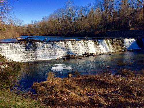
Just north of Harrisburg was the little town of Dauphin and I stretched out my legs near a waterfall. Too bad the Stoney Creek bar was closed or a stony like me might have just gotten a Bloody and sipped it waterfall-side.
![Da Waterfalls of Dauphin]() Da Waterfalls of Dauphin
Da Waterfalls of DauphinOne of the best things about mountain villages along rivers are all the train bridges, now over a century old. Sure, it looked like a snow-globe-jigsaw-puzzle-landscape-picture-hybrid of beauty, but more interesting to me was how each bridge had a design and a weather-mixed-with-the-composition color. Small arches spanning the whole river and a metallic gray bolt-heavy bridge, or a maroon rusted-out suspension, or perhaps passing a concrete beam bridge cracked yet level or the classic lattice truss, black and ominous.
Two slices of banana pepper pizza, a cliff bar, a PB&J sandwich on wheat and a zip lock bag full of Goldfish had already been consumed by hour 5.
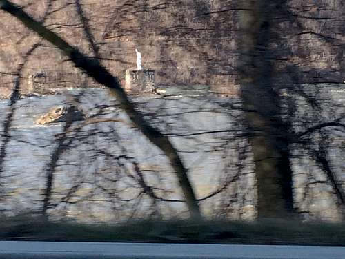
The visual landscape continued to get better as I approached Harrisburg. The Juniata fed into the massive Susquehanna River, which made up the western border of the state capital. The Susquehanna was extremely wide by any river’s standards, but shallow, so you could see the water rippling over rocks and small islands jutting out at random. What the hell was that white statue in the middle of the river?
![Pirate Lady Liberty]() Pirate Lady Liberty
Pirate Lady Liberty Turns out a lawyer created a replica of the Statue of Liberty out of blinds and plywood back in the ‘70s and in the middle of the night, erected it with some friends. It was a mystery for years until he eventually came forward. In the ‘90s, it was destroyed, but a new one was soon created and re-erected.
Full story here.
In Harrisburg, I jumped on the dumb toll road of I-76, as it was only $7 to get to my exit, #312, Lionville. There, you could instantly feel the impact of big city, as northern Delaware was essentially a suburb of Philly. Trillions of stop lights and commerce and all the busy businesses and everyone all going somewhere, efficiently. Everything had a sign. A logo. And the company names were no longer the last name of the person that worked the most at the store. His name was now manager and the name on the sign now referred to the comfort of knowing exactly what you are going to get, regardless of the mediocrity.
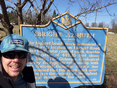
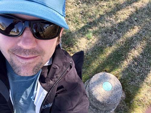
Ebright Azimuth, the highpoint of Delaware, was my first sidewalk summit—but it was still awesome. I was a tourist to the place, not so much a highpointer. Had seen so many people’s posts and pictures that it felt like I was visiting Gettysburg.
![Delaware Highpoint Sign]() Delaware Highpoint Sign
Delaware Highpoint Sign The blue “wordiest” highpoint sign ever, the sidewalk that was cut around the survey marker, the empty field in the background. All so perfect to me. Well, except that that spot wasn’t the true summit. A new secret survey marker that was somewhere between three to 20 feet higher existed “in the vicinity.”
Backstory (that may or may not be made up): the original highpoint was established and a survey marker placed. Then, like, 30 years later, they were all like, “Ummm, dude, I think 300 yards over there, is like, da true highpoint.”
A new marker was subsequently placed. Some cried foul, claiming that that dirt was pushed up higher due to development, not a natural occurring event, so the original highpoint was the real one. Some say the second marker isn’t even in the state of Delaware, anyway. Either way, anything below 500 feet, if you are “in the vicinity” of the highpoint, it counts in my book.
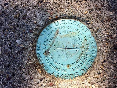
Buttttttt, I still “trespassed” and found the second survey marker that was higher.
![Secret (not so secret) True Summit Marker]() Secret (not so secret) True Summit Marker
Secret (not so secret) True Summit Marker When I got back in my car, I put “Jerimoth Hill” into the map app and a voice started guided me towards Rhode Island. It was five hours NE from where I was then. Mentally and physically, I could have done it, but bad weather was coming. I would have been stuck in New England for an extra day. One right turn towards Rhode Island and I pulled over. Sometimes you have to accept that you can’t do it all. I headed home.
Into the 10th hour of the trip and was feeling enough fatigue that I just wanted to set the cruise, so it was I-76 all the way across PA to Pittsburgh. An hour from that city I passed the town of Somerset, with its “Back to the Future” replica clock tower, and saw myself four years ago. I was just finishing the Maryland and Pennsylvania highpoints and got on I-76 to head home at the Somerset junction. Not a lot had changed between my two selves.
The radio news reported on the massive winds I’d been experiencing: about a Michigan basketball team that was blown off the runway at an airport, power outages from Chicago to the East Coast, about sustain winds of 40 and 50 mph all across the Midwest.
After paying the toll in Pittsburgh of like $40, I was tired of the game and the interstate, so I took county roads 3020/2004 towards freedom. Like, literally, towards the town of Freedom, PA.
2004, or Freedom Crider Road, was a beautiful, curvy, narrow two-laned (without the middle yellow line) backroad running along Crows Run River. Deep gulley drop offs on one side, forest hills on the other—the ground still full of last fall’s leaves yet devoured by the soil, buds just starting to appear on the deciduous tree limbs.
Freedom was on the Ohio River, and I descended down 9th street into the train yard bordering the water. Gorgeous. But weathered. A lot of the jobs were gone and the buildings showed the lack of financing needed for upkeep. Pockets of litter in doorways, dented siding and a lack of display in the downtown storefront windows.
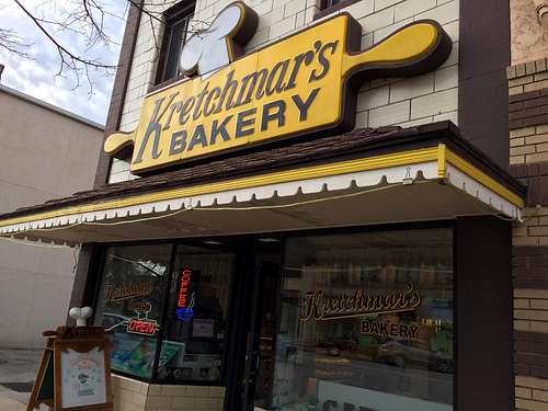
The economic devastation continued as I moved east along the Ohio River. Yet, in the middle of the depression, the town of Beaver was unaffected. A thriving, bright red-bricked downtown with tourist shops and one of the best bakeries in the Midwest: Kretchmar’s.
![Voted Best Bakery Ever by Me]() Voted Best Bakery Ever by Me
Voted Best Bakery Ever by MeLife along the Ohio River around the tri-state line of Ohio, Pennsylvania and the fingernail tip of West Virginia resembled the skeleton towns created for missile testing in the desert—the appearance of community but totally hollow. Riverfront homes that should have been valued over 200K were dilapidated and caving. Side by side residences along the river’s erosion-made hill, porches slanted and crumbling.
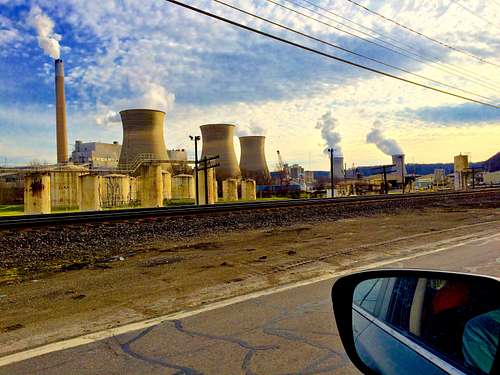
![Gateway to Economic Hell]() Gateway to Economic Hell
Gateway to Economic HellThe image of the abandoned car lot in East Liverpool, OH, with the two vehicles still on the showroom floor, encased in glass, museum-like, perfectly illustrated the struggle of the river wasteland.
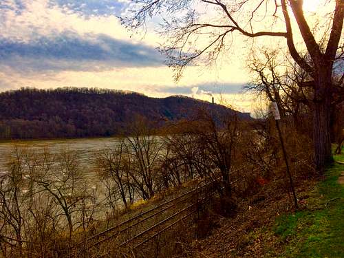
All the coal and power plants along the highway that provided the livelihood had been downsized or had vanished. But the pollution remained—I wouldn’t have even swam in the whiskey water of that section of the Ohio, glazed on the top with the rainbow hues of an oil slick, let alone have eaten the bottom-dwelling muck-swimming catfish.
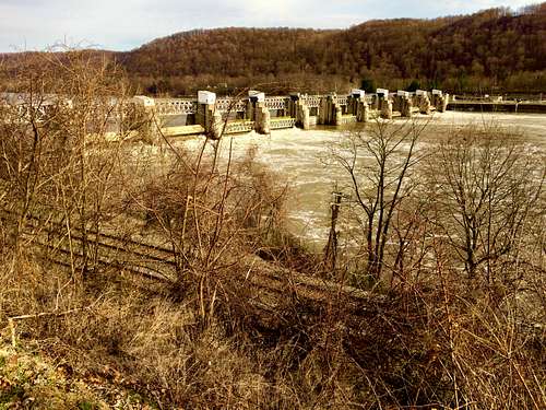
![Near the Head of the Ohio River]() Near the Head of the Ohio River
Near the Head of the Ohio RiverAnother winter highpointing season came to and end, after 15.5 hours of solo driving and 1,000 miles logged. Just Rhode Island and mighty Maine left to do this side of the Mississippi. But first, our focus now shifts to summer, and to the 50-mile trek of Gannett Peak, Wyoming.


Comments
Post a Comment