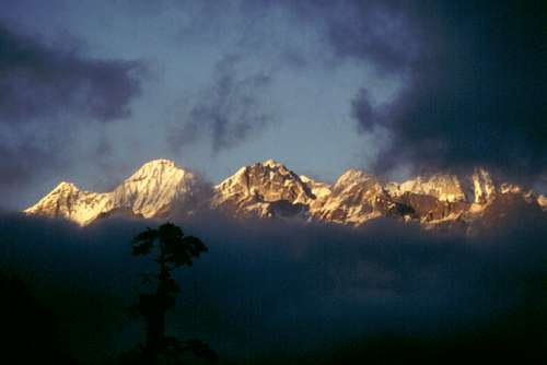
Situated amongst the superb Himalayan peaks of the secluded Indian state ofSikkim, the Goecha Là trail allows to get the Goecha Là - a pass 4940 meters high (some sources quote it at 5002 m.) - where to take an outstanding view over the mysterious South-East face of Kangchenjunga m. 8585, the third highest peak on earth and the less climbed amongst all the 8000s, situated on the boundary ridge between Sikkim and Nepal. Along the Goecha La trail is possible to take beautiful views of 14 other great mountains.
Kangchenjunga from Goecha Là
Kangchenjunga, which name means “Five Treasures of Snow” and also “The Dwelling of the Five Treasures”, in reason of its five summits, was first climbed in 1955 by Joe Brown and George Band, members of a British expedition; since the first ascent, the mountaineers use to stop the climb a few meters below the summit, following the tradition of the first summiters, as Kangchenjunga is considered to be holy. It has been my third himalayan trail, after Baltoro-Concordia-K2 Base Camp in Karakoram and Markha Valley Trek in Ladakh. Moreover the trail is wonderful also from the point of view of natural beauties. The diversity of flora is amazing. You will pass through forests of rhododendrum, pine and magnolia trees and pass Dzongri above the tree line you will reach the wildflower-filled alpine meadows.
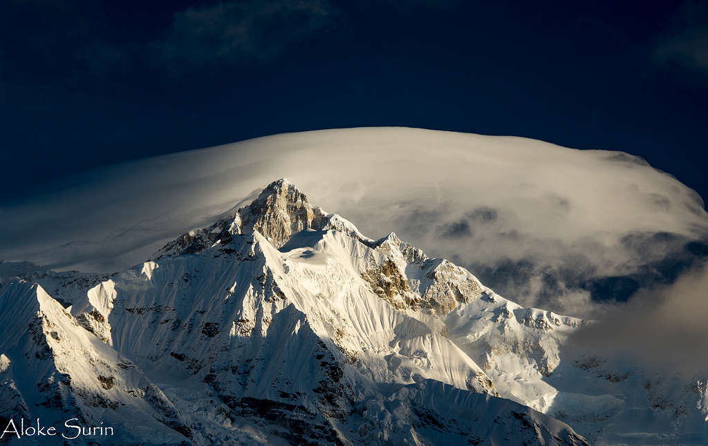
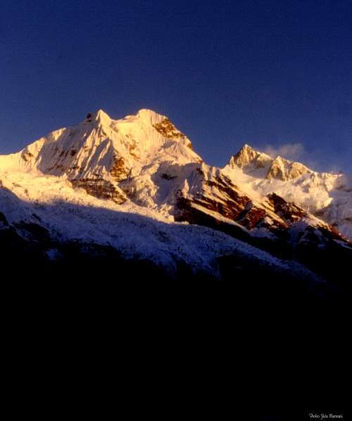
Kanchenjunga as seen from Lamuney - Photo alokesurin
Bagdogra (West Bengala) to Gangtok, the capital of Sikkim
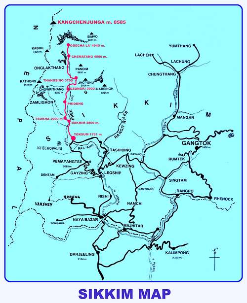
Sikkim is divided in four districts: East Sikkim, West Sikkim, North Sikkim and South Sikkim. The Goecha Là trail is situated in the Western district. Sikkim currently doesn’t have an airport, although the Pakyong airport (30 km. from Gangtok) is expected to be completed in 2013; the nearest airport is situated in Bagdogra, West Bengala (124 km. from Gangtok). Regular flights connect Bagdogra with Calcutta and New Delhi. The two closest railway stations are Siliguri (114 km.) and New Jalpaiguri (125 km), having direct connections with Calcutta and New Delhi. After a good trip by mini-bus via Siliguri, we get to Gangtok in late evening, feeling the final shiver by meeting several vehicles with lights out! It’s quite recommended to end the trip with the daylight, as some persons use to drive in such a manner!!!
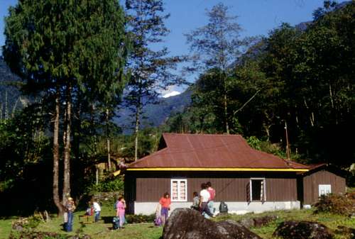
Gangtok to Yoksum, the ancient capital of Sikkim
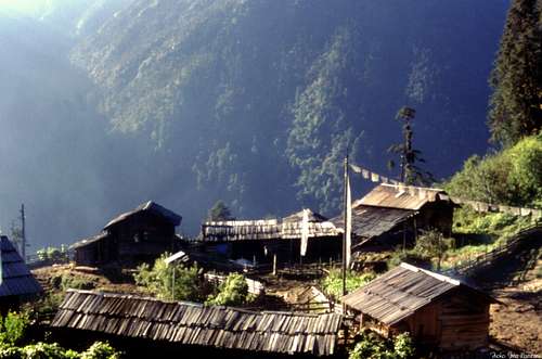
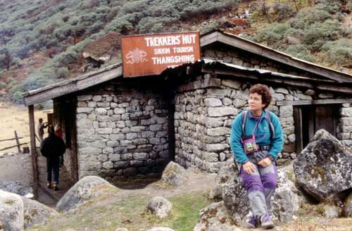
Our lodge in Yoksum
Yoksum 1781 m – 40 km from Pemayangtse – is the starting point for all the treks in West Sikkim, a fairly large settlement in West Sikkim. It was once the capital of Sikkim. Now Yoksum is the campground of the trails to Goecha La, Kanchenjunga and many other mountains and home to many sacred monasteries and lakes like Tashiding monastery, Kartok monastery, and Khecheopalri Lake.
The trip to Yoksum is pleasant, but an apparently insignificant accident – a huge black snake crossing the road just in front of our 4WD - creates some concerns in the guides, explaining the fact as a signal of bad luck for our trek. Anyhow, we get without other problems to the historyc hamlet of Yoksum or Yuksam m. 1781, the ancient capital of Sikkim, a nice village with a peaceful atmosphere and spend the night inside a Trekkers Hut.
1st day: Yoksum 1728 m to Tsokha 2957 m via Bakhim - October 19th
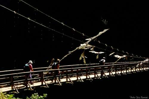
The hanging bridge between Yoksum andTsokha
The small hamlet of Tsokha
- Altitude: 5670 ft (1728 m) to 9701 ft (2957 m) - Difference in height: 1230 m. - Kilometers: 16 - Time required: 5 to 6 hours
To take it easy this leg can be divided in two ones with overnight in Sachen 7150 ft (2179 m).
We wake up at dawn and after a fight with a cloud of small leechs having covered our packs during the night, we are ready to start walking. As for all the treks in Western Sikkim, we start to walk from Yoksum. We head towards North, start ascending uphill and follow the gorges of the Rathong River. The itinerary enters soon the dense luxuriant sub-tropical forest, lying on the orographical left bank of the Preig Chu River. We cross two tributary streams of Preig Chu in succession, the Paha Khola and the Tshushay Khola, by two suspended bridges, then we continue up and down and finally we descent for about 250 m. to the main river bank. We cross the river by another exciting suspended bridge, getting to the orographical right bank. After the bridge some steep slopes inside the very dense covered forest brings us to the tiny hamlet of Bakhim at about 2800 m, from where there are good views of the trail. We get to the BakhimRest House, but we’re not tired, so decide to continue walking again. We enter inside the magnificent forest of silver fyr and cypress, becoming now much more dense, on a characteristic path lined with sky embracing trees, to get the smallhamlet of Tsokha 2900 m, once consisting in a few houses and a monastery nowaday a growing village. The monastery is a peaceful place worthy of a visit. Located at a height of 2900 m above the sea level, Tshoka offers a glimpse of towering snow capped Pandim and few others. The summit of Pandim 6770 m can be seen behind a ridge in the North direction. Overnight stay inside the trekkers lodge.
2nd day: Tsokha 2957 m to Dzongri 3900 m via Phedang - October 20th
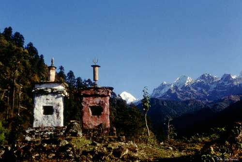
Chortens near Tsokha
Tsokha trekkers lodge
- Altitude: 9701 ft (2957 m) to 13080 ft (3987 m) to 13024 ft (3956 m) - Difference in height: 1030 m - Kilometers: 10 - Time required: 4 hours
A superb day of walking. From the mountain lodge we head to the monastery on the shore of a small lake. A steep trail leads us again inside the forest. It's a scenic forest of high trees and magnificent huge rhododendrons, showing flowers of many colours during the pre-monsoon (usually the blooming is on May 1st/2nd week). Unfortunately now it’s October, the post-monsoon period, and we can’t see this beauty, quite renown. The trail is well-laid and it begins a stretch with the bottom on wooden logs as rain turns it pretty muddy. Then the wooden bottom turns into a regular stony trail that in 20 minutes climbs quickly, exits the forest and reachs Phedang 3683 m, on a wide clearing dominated by a high watching tower with a log hut and a few wooden benches. The views over the surrounding mountains are amazing. Here the trail forks with one that goes right, leading to Kockchurang. We instead take the straight path to Dzongri across the clearing, that starts to climb immediately along the dwarf rhododendrons that line the slope. After a steep ascent, we gain the top of Deorali, a col with a chorten and a multitude of prayer flags. This is the highest point of the days trek at 13080 feet. There are spectacular views of the peaks from here (Pandim ranges and Kabru) appearing and disappearing inside the mist. The trail gently descends amongst meadows and rhododendrons to the cold basin of Dzongri 3900 m. The Dzongri trekkers hut appears suddenly at the bend in the trail. Dzongri is located on a large basin, mostly meadows, surrounded by the mighty peaks of the Kanchenjunga range. – 4 hours from Tsokha - Overnight stay inside the trekkers hut.
3rd day: Dzongri 3956 m to Lamuney 4150 m - October 21th
- Altitude: 13024 ft (3956 m) to 13700 ft (4150 m) - Difference in level: 300 m. + 400 m. + 400 down walk - Kilometers: 8 - Time required: 5-6 hours
In Dzongri the path bifurcates itself in two ones. The shorter left trail leads to the Himalayan Mountaineering Institute Base Camp. We follow the right path, the way towards Goecha Là via Thangsing, Lamuney, Samiti Lake andChematang; we soon begin rising steeply to the Dzongri Là col m. 4100. A 360° view of the eastern Himalayan ranges is visible from the Dzongri Viewpoint. Located at the height of 4250m on the top of the hill, the Dzongri Viewpoint provides sublime and captivates scenery of the entire Himalayan range. Once getting the col we take a superb view to Pandim m. 6691, Kabur Dome and Simvo m. 6811. It’s also possible to see Kangchenjunga and its accompanying peaks in clean days, if watching towards North, but it’s not the case today, because of many clouds hiding them. We do a short digression by walking on the ridge above the col to get the four chortens. We descend on the col and then downclimb on a steep trail in the opposite side of the col. Some strenuous up and down lead us to a group of prayer flats.
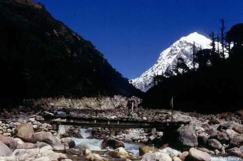
The wooden bridge between Dzongri andThangsing
View from Dzongri Là
From here it starts a very steep descent among the rhododendrons (400 meters downclimb) getting the Preig Chu River bank. We cross the river on a wood bridge, then we walk up to the wide plane of Thangsing m. 3800, dominated by the beautiful Pandim m. 6691, appearing at intervals in the midst of the fog. Thangsing is a valley layered with abundant pastures. After about 3 km crossing the plane, we climb up on a steep trail to the smaller basin. A steep path rises to the basin of Lamuney, where it's located the small Samiti Lake. Overnight stay inside a lodge, not a good night, due to the very low temperatures inside the lodge. This is one of the very windy place.
4th day : Lamuney 4150 m to Goecha Là 4940 m – Back to Thangsing 3800 m - October 22th
Dawn at Chematang and Kangchenjunga on the right
- Altitude: 13160 ft (4150 m) to 16207 ft (4940 m) up/16207 ft (4940 m) to 12470 ft (3800 m) down - Difference in height: 790 m. walk up and 1300 m. walk down - Kilometers: 5 walk up and 7 walk down - Time required: 4 hours walk up and 5 hours walk down
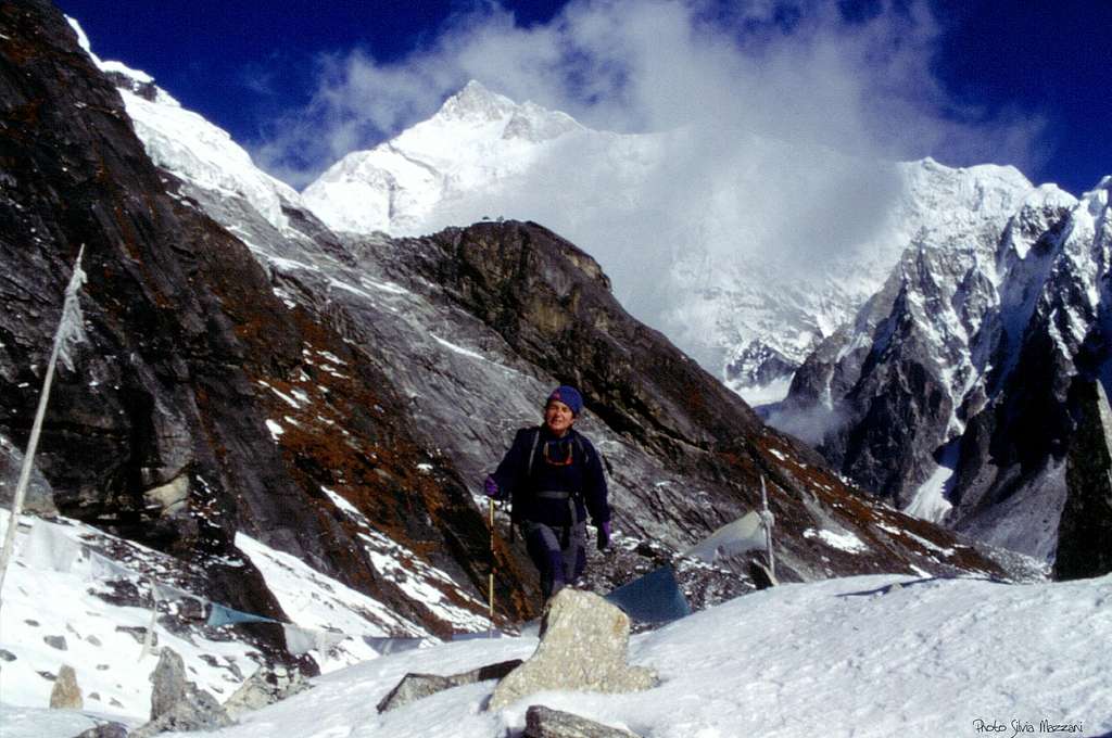
Quite a long day, but a superb climb up! An alpine start is required to get without problems to the magnificent snowy saddle named Goecha Là at the height of 4940 m., an outstanding balcony to the South-East face ofKangchenjunga. This departure at a "wild time" is justified by our hope to reach the Goecha Là before the arrival of the mists, that the previous days have risen about at 10 am, and would prevent the view of the majestic peak. When we wake up at 3 o’clock unfortunately our guide is not inclined to leave his bed, so we manage to find the trail by ourselves. Other people belonging to our group seems to give up the scheduled ascent and only three people, a friend of mine, me and the cook-man are enthusiastically ready to climb up to our ultimate destination in the end: the Goecha Là. We start reaching the orographical right shore of Samiti Lake, finding some difficulties in finding the trail, not at all obvious. The trail flanks the lake before climbing steeply on the moraine ridges above the lake. As we gain height the mountain views are increasingly more spectacular. We cross two small notches, then rise to the wide magnificent white sandy basin of Chematangm. 4500. We start crossing the basin: the atmosphere is truly magic in early morning, surrounded by magnificent iced and high peaks at sunrise. Our faithful and gentle cook-man, professing Buddhism, falls on his knees seeing such a beauty!
Huge cairns on the first rocky saddle
Chematang moraine
At the bottom of Chematang basin we start climbing up the moraine, where Kangchenjunga is appearing. We head to right, climbing to a rocky saddle with huge cairns, taking a gorgeous look on Kangchenjunga, Talung m. 7349, Jannu m. 7720, the rocky triangle of Kabru m. 7338 and on the snowy Goecha Là, just in front. A snowy ridge amongst huge granite blocks, then a steep descent lead to a first small notch; finally another climb up allows to get to the ultimate destination: the Goecha Là m. 4940, overhung close up by Goecha Là Peak m. 6120. The view is quite superb on the South-East wall of Kangchenjunga m. 8585 with its accompanying peaks, the Zemu Glacier and Siniolchu m. 6864. Back to Thangsing. Overnight in the Thansing trekkers hut.
Coming down on the sandy Chematang basin
5th day: Thangsing 3800 m to Bakhim 2800 m via Phidong - October 23th
- Altitude: 12470 ft (3800 m) to 9186 ft (2800 m)
- Difference in height: 1000 m - Kilometers: 18 - Time required: 5 to 6 hours
From Thangsing we start to come back to Tsokha on the same path of the ascent, enjoying beautiful views over Pandim we haven’t see well while hiking up because of the mist. We cross the Preigh Chu River on the wood bridge and getting to the fork inside the forest we manage here to do a nice variant: instead of climb up to Dzongri with a difference in level of 400 meters, we take the path to Phidong, walking up and down inside a magnificent forest of huge rhododendrons and getting to this nice village. From here we reach the same wide glade of walking up and descent to Tsokha 2900 m, then to Bakhim 2800 m. Overnight stay in the Bakhim Rest House.
Thangsing trekkers hut
6th day: Bakhim 2800 m to Yoksum 1728 m - October 24 th
- Altitude: 9186 ft (2800 m) to 5670 ft (1728 m)
- Difference in height: 1070 m. - Kilometers: 14 - Time required: 3 hours
From Bakhim we follow the same trail inside the forest to Yoksum.
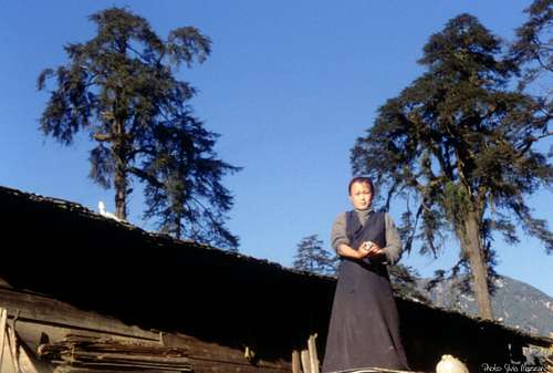
A young woman in Bakhim
7th day: Yoksum 1728 m to Dubdi Monastery - October 25th
The Dubdi Monastery near Yoksum
- Difference in height: 250 m.
– Kilometers: 3
- Time required: 1 hour
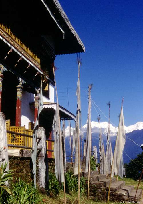
After overnight stay in the Guest House of Yoksum and before starting towards Darjeeling in West Bengala, we really have a good idea: to take a look to the ancient Dubdi Monastery. This quite short walk up to the superb Dubdi Monastery, also called Yoksum Monastery an lying on the top of a hill, can be missed. It was the first monastery established in Sikkim in 1701, and it’s part of a Buddhist pilgrimage circuit.
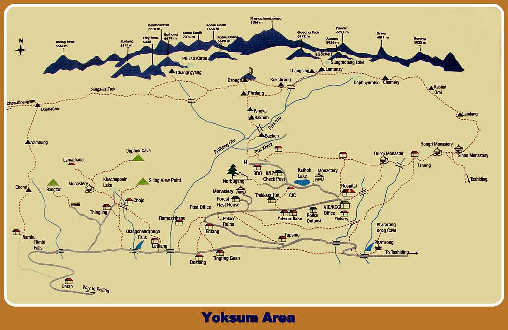
The Himalayan peaks observable during the Goecha Là trail
- Kanchenjunga 8586 m - Talung 7349 m - Rathong 6679 m - Kabru N 7353 m - Kabru S 7318 m - Koktang 6147 m - Simvo 6812 m - Kabru Dome 6600 m - Kabru Forked 6100 m - Pandim 6691 m - Tenchenkhang 6010 m - Jupono 5650 m
When to go
The monsoon season in Sikkim is between mid May and September. The best season goes from mid March to mid May, the pre-monsoon period, and from October to mid November, thepost-monsoon period. In the first part of the pre-monsoon period, until early April, the upper part of the trail remains under snow. You might find light snow in the high altitude areas even in October and November.
The monsoon period should be avoided, as the weather is bad, the trails become slippery and roads remain blocked due to the heavy rains. Even the winter period is not favorable in reason of the heavy snowfall.
Nice one :) We did the same trek but different route. We took a round trek instead walking back the same way.
Me, my brother and our father did a trekking late September 2014 with Sikkim Travel Express (http://www.sikkimtravelexpress.com) on the Goecha La/Kasturi route. The crew consisted of knowledgeable local (young) Sikkim people. Our guide spoke very good English to explain about the Kanchendzonga area, but you have to ask a lot to pull out the information. The service was great, food was according the circumstances and the tents were spacious enough. The scenery during track was amazing, although the weather was usually cloudy and rainy (late September). Better to go in late dry season, just before winter. This trekking is ideal for those who want to go into remote areas with no mass tourism.
I strongly recommend to take the Kasturi route unless you don't like challenge. The Kasturi route is very pleasant trail specially when you don't want to return the same trail back. View in particular was really amazing and we spend our last two nights with a local family and in a Buddhist monastery.
Sikkim Travel Express and the crew did its best to guide us through the trail, but make sure to get a right information forehand.
Hi Joel,
yes, Sikkim is just a pleasant and friendly country and treks are wonderful and above all not too crowded. A friend of mine is planning to go there next November and the round trek you took seems very interesting. I'd suggest it to my friend!
Thanks for the info!
Silvia
Children refers to the set of objects that logically fall under a given object. For example, the
Aconcagua mountain page is a child of the 'Aconcagua Group' and the 'Seven Summits.' The
Aconcagua mountain itself has many routes, photos, and trip reports as children.


Comments
Post a Comment