Graslitzen from Förolach, E route

Graslitzen from Förolach, E route

Page Type Page Type: Route
Location Lat/Lon: 46.65431°N / 13.46839°E
Additional Information GPX File: Download GPX » View Route on Map
Additional Information Route Type: Hiking
Seasons Season: Spring, Summer, Fall
Additional Information Time Required: Most of a day
Additional Information Difficulty: Medium hard hike (T3)
Sign the Climber's Log

Overview

Above St. Steben
Above St. Steben
Also this is a medium hard, quite long hiking tour. The ascent from St. Steben church up on alpine meadows is very steep, quite demanding, despite woods there are several picturesque places. Then from nice meadows we quickly gain the east ridge and foresummit, finally the quite long summit ridge awaits us. With the west approach from Förolach this route can be nicely combined into a round tour.

General Information

Graslitzen map
Difficulty: It's a medium hard hiking tour. There's no climbing, only a few details of scrambling, but many steep slopes to cross. There some additional care is required. On the Swiss Hiking Scale its difficulty is graded T3.

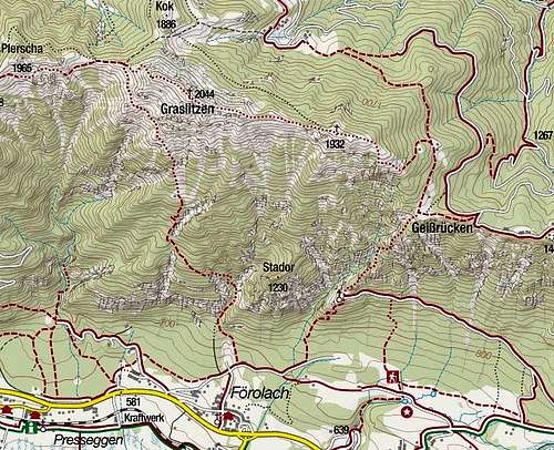
Orientation: It's quite easy. The route is all the time well marked. Map to be recommended: Kompass, Gailtaler Alpen, Karnische Alpen, 1:50000. See also the GPX track in the header!

Slopes Orientation: South oriented below in the woods, then more east oriented to the main ridge, with a short forrest passage oriented northward.

Exposition: There is no big immediate exposition on the path, but the slopes in the forrest are very steep, some passages exposed, so a mistake could easily become fatal.

Objective dangers: Realistically none.

Best season: Late spring, summer and autumn till the first snow.

Gear: Good shoes and poles are sufficient in summer conditions.

Tour start: The end of the road above Förolach, 619 m. See the parent page how to drive till there!

Highest point: 2044 m.

Altitude to overcome: cca 1450 m.

Time for ascent: 4 h.

Route Description

St. Steben
St. Steben
A ravine in the south face of Gaisruecken
Steep ravine
From the parking place we continue by the forrest road towards the east. On all crossroads we keep left, first we take another forrest road, then a good path. The route to St. Steben church is well marked. A pleasant ascent brings us through the woods under the final steep slope. There the path overcomes a few easy rocky steps, passes a nice, old chapel and reaches the church. This place can be reached also from the villages more to the east of Förolach: Köstendorf and Susawitsch.

From the church we continue close to the rugged ridge towards the north. The path soon becomes very narrow and often crosses very steep slopes. Especially on a descent or in poor conditions it requires a lot of care. A few times we reach a notch in the steep ridge and then the path again continues left and by the ridge up. On the right side soon a distinct break on the slope forms. On the other side of a wild ravine there are precipituous rocks. When we reach the top of a wild, narrow gorge, the path again turns left up the slope, after which the last steep, partly rocky section brings us on the edge, where nice alpine meadows begin. From the right over Gaisrücken the marked path from Windische Höhe road pass joins, and in front of us is already the cross.

Geißrueckenkreuz
Gaisrückencross
Near Schnabelhuette
Near Schnabelhütte
Graslitzen E foresummit
The eastern ridge
From it we continue across the slopes on Köstendorfer Alm (water source). Above the meadow the path turns left and through a forrest we reach Schnabelhütte, after which the path continues mostly by the here still broad east ridge. Only higher it detours a steep rocky part of the ridge by the right (NE) side. When on the ridge again, the grassy slopes soon bring us on the east summit of Graslitzen, 1932 m. The continuing ridge on the main summit is narrow, 1.3 km long, but all the time easily passable. On some rocky parts the route still requires a safe step. Have a look under your feet, you will enjoy the panorama on top!

Parents 

Parents

Parents refers to a larger category under which an object falls. For example, theAconcagua mountain page has the 'Aconcagua Group' and the 'Seven Summits' asparents and is a parent itself to many routes, photos, and Trip Reports.