
-
 6174 Hits
-
 83.69% Score
-
 17 Votes
|
|
Route |
|---|---|
|
|
46.88670°N / 10.85070°E |
|
|
Mountaineering |
|
|
Spring, Summer, Winter |
|
|
Less than two hours |
|
|
middle - up to 50° |
|
|
Overview
 North Ridge
The north ridge of Hinterer Brochkogel is one of four ridges to the summit of the third highest peak in the Oetztal Alps and the fifth highest summit of Austria. It is a nice ice/snow climbing ridge up to 50° the whole year round. From the foot of the ridge on the upper Taschach-glacier it is a 200 m climb. The ridge requires 1 hour up. If you want to use a rope you have to schedule 90 minutes. The conditions are normally very good (Maybe one side blank ice and the other side good snow). If the north-west face of Hinterer Brochkogel has too much blank ice in the upper part at the ice nose it is very popular to shift to the north-ridge.
Getting There
 Looking up the second part
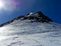 North ridge
The trailheads for routes to Hinterer Brochkogel are Mittelberg in the Pitztal and Vent in the Oetztal. At Mittelberg you can choose between the long and the short way. The short way is using the cable-cars of the ski-resort of Pitztal-Glacier to Mittelbergjoch. Or you can hike through the Taschachtal towards Taschachhaus (4h). The other trailhead is Vent in the Oetztal. From here you can hike towards Breslauer Huette (2,5h).
 Wildspitze and Hinterer Brochkogel with North Ridge
 View from Ski-depot
Route Description
 On the ridge
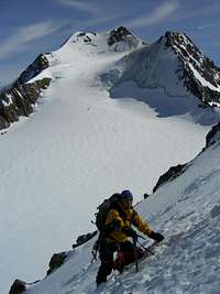 Wildspitze in the background
The start of the ridge is at a height of approximately 3.400 m. The route starts at the bergschrund. Normally you have no problem to cross the bergschrund. The first part is nice climbing up to 45-50°. The north-west side of the ridge has maybe more ice than the north-east side. Stay at the snowy east side. Climb up to a big rock at the half of the ridge. Climb left around the rock and follow the sharp snow ridge (50°) up to a another big rock. On the sharp ridge stay on the north-west side. Climb right around the last big rock and follow the last snow passage to the summit of Hinterer Brochkogel.
Descent: The same way back or over the south-east ridge (normal route) to Mitterkarjoch (30min) and back to the start of the north-ridge (15min).
  |