

-
 19910 Hits
-
 87.67% Score
-
 25 Votes
|
|
Mountain/Rock |
|---|---|
|
|
46.88670°N / 10.85070°E |
|
|
11925 ft / 3635 m |
|
|
A note from the SP Staff

IN MEMORY OF RAHEL MARIA LIU
Rahel Maria Liu died tragically during an attempted climb of the Innominata spur on the southern (Italian) face of Mont Blanc in August of 2004. Rahel was a charter member during SP's early days, and her work here remains among the best of SP's collected contributions. Her knowledge and experience has made an impact on the world mountaineering community, and her warmth and friendship will be long remembered among her many friends and fellow members here at SummitPost. She will be greatly missed by us all.
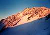
Overview
The Hinterer Brochkogel is a little mountain with an interesting northwestface. In combination with the northfaces of the Petersenspitze and the Taschachwand it is part of the so called "Pitztaler Eisexpress". But because in summer the northface of the Taschachwand is quite snowless and therefore objectively dangerous, people today normally climb only the northface of the Petersenspitze and the NW-face of the Hinterer Brochkogel and add the NW-ridge to the Wildspitze instead of the Taschachwand. Besides the northface there are different ways to the summit (SE-ridge, S-ridge, SW-flank, W-flank, W-ridge, N-ridge, NE-face). Many people go there, mostly the normal route (SE-ridge) in combination with the Wildspitze.For the Routes compare the section Routes-Overview below.
 |  |  |  |  |
Getting There
 Hinterer Brochkogel (East Face)
- a. You can come from the Taschachhaus (2433 m).
- b. You can come from the Vernagthütte/Würzburger Haus (2766 m).
- c. You can come from the Breslauer Hütte (2840 m).
- d. You can come from the Braunschweiger Hütte (2759 m).
2. To the Taschachhaus:
- You reach the Taschachhaus: from the Taschachalm or from Mittelberg (1616m) in 2-2,5 h on a road (at the beginning). It is a marked way all the time, which you have to follow straight on. You can see the Taschachhaus. The long way on the road is quite even until you reach the station of the material cable car. You can also go by mountainbike to this place and leave your mountain bike here. From this point, you have to continue on a smaller hiking way which goes steeper up behind the bridge. Follow this way over the hangs till you reach the hut.
- You reach Mittelberg by bus or car on the road through the Pitztal from Imst (train station) via Wenns, St. Leonhard and Plangeross.
- You reach Imst by train or car on the A12 from Innsbruck (airport) in the E or mostly on the road E60 from Bludenz in the W.
3. To the Vernagthütte/Würzburger Haus (2766 m):
- You reach the hut from Vent to the hut: in 3,5 to 4 h. You have to follow the marked hiking way no. 920. You only have to follow the valley all the time.
- You reach Vent on the road through the Ötztal from Ötztal (trainstation) via Ötz, Sölden and Zwieselstein. In Zwieselstein, you have to turn right to the Venter Tal.
- You reach Ötztal by train (station: Ötztal Bahnhof) or car on the A12 from Innsbruck (E) or from Bludenz (W) on the E60 and A12 via Landeck. Turn off at Ötztal.
4. To the Breslauer Hütte (2840 m):
- You reach the hut to the hut: from Vent in 2,5-3 h or with the cable car 1 h less. You have to follow the marked hiking way all the time. There is nothing special or difficult.
5. To the Braunschweiger Hütte (2759 m):
- a. from Mittelberg in 3 h on a marked hiking way. Nothing special or difficult. Simple hiking.
- b. from the Gletscherbahn-middle-station in 1 h: Easy glacier walk. This is the shortest ascent. You cannot miss the hut.
- c. from Sölden over the Pitztaler Jöchl on a marked way in 5,5 h; you go from Sölden to the Rettenbachtal and to the Rettenbachglacier (to the highest parking place on the glacier route at 2800m). You climb up the northeastern glacierpart to the Pitztaler Jöchl. Now you turn right, with W-direction, from the Jöchl in 20 min. to the Niedere Karlesschneid and in zigzag down to the hut. From the parking place in Rettenbach in 2 h.
 |  |
Routes-Overview
 North-Ridge
 South-East-Ridge
 NW-flank
- partly ice, 1 h, from Breslauer Hütte, Braunschweiger Hütte, Vernagthütte, Taschachhaus
2. S-ridge
- 3-4 h, a little bit rock climbing, from Vernagthütte
3. SW-flank
- 1 h, from Vernagthütte
4. W-flank
5. W-ridge:
- II (passages) (cornices!), best ascent from Vernagt
6. NW-face
- 55° (80° var.), 250 hm - 5 pitches, face: 1,5 - 2 h, wonderful ice tour
7. N-ridge
- steep ice-ridge, 2 h, middle difficult
8. NE-face
- 200 hm, ice flank, but in the topmost part rock, less difficult and steep than the NW-face, big danger of rockfall
according to Klier
 |  |  |  |
  |
Accomodation in the area
1. Taschachhaus (2433 m)The Taschachhaus is situated on the Pitztaler Urkund, on a green plateau above the tongues of the Taschach- and the Sexegertenglacier.
- according to Klier:
- 125 beds
- winter room with 16 beds in the old hut (open)
- serviced from end of june to september
- phone: ++43(0)5413/8239 (in the valley: ++43(0)5413/8205 or 8220)
- internet: DAV or Taschachhaus
2. Vernagthütte/Würzburger Haus (2766 m)
The Vernagthütte is situated in the end of the Rofenvalley on the N-side of the Guslarglacier.
- according to Klier:
- 174 beds
- winter room with 20 beds (open), in an own hut near the main hut (30 m)
- serviced from the beginning of march until the middle of may, at Whitsun, from the end of june until the end of september
- phone (valley): ++43(0)5254/8128
- internet: Vernagthütte
3. Breslauer Hütte (2840 m):
The Breslauer Hütte is situated at the foot of the Ötztaler Urkund and at the N-hang of the Rofental.
- according to Klier:
- 221 beds
- winter room with 25 beds (open)
- serviced from end of june until the beginning of october
- phone: ++43(0)5254/8156 (valley: ++43(0)5254/8153)
- internet: Breslauer Hütte
4. Braunschweiger Hütte (2759 m):
The Braunschweiger Hütte is situated in the end of the Pitztal on a hilltop above the Karlesglacier.
- according to Klier
- 150 beds
- serviced from middle june till middle october
- winter room with 11 beds open
- phone: ++43(0)5413/8236 (valley: ++43(0)5413/535)
- internet: Braunschweiger Hütte
When To Climb
Books & Maps
BOOKS:ISBN 3-7633-1123-8
MAPS:
- 1:25000 no. 30/6: Ötztaler Alpen. Wildspitze
(to order at DAV Service)
Infos
1. GENERAL INFOS:- www.pitztal.at
- Mittelberg (also information concerning the bus)
- Vent (also information concerning the bus from Sölden)
- Plan of Ötztal
2. WEATHER
- www.alpenverein.de
- www.tiscover.com
- avalanches
- Phone: ++49-89-295070 (DAV)
- Avalanches (Tyrol): ++43-512-1588 (OeAV)
External Links
- Austrian Map online
Online digital maps of Austria (OEK 50, OEK 200 and OEK 500) by the BEV (Bundesamt für Eich- und Vermessungswesen) - in German
dmiki - Mar 23, 2010 7:58 am - Voted 10/10
Breslauer Hütte winter roomnow has 25 beds
Sebastian Hamm - Mar 27, 2010 6:13 am - Hasn't voted
Re: Breslauer Hütte winter roomthanks, I will change it
dmiki - Mar 27, 2010 5:26 am - Voted 10/10
Ötztaler EisexpressI think this is rather called 'Pitztaler Eisexpress'
Sebastian Hamm - Mar 27, 2010 6:15 am - Hasn't voted
Re: Ötztaler EisexpressYou are right! It's Rahel's old text. I will change it.