Squares Peg A Plan
With a holiday weekend fast approaching, several ideas were made for which mountains to possibly attempt. The first idea was the plan which gained the most traction, Mount Shuksan. Gimpilator and I were invited on that trip by Edward Earl. For several weeks that was the goal for Independence Day weekend, until it was realized that the conditions on the mountain were not improving. If anything, the conditions were worsening, an unusual occurrence for early July.
Soon after the Shuksan plan disintegrated, I found out that I would be needed for a non-mountaineering reason on Monday, leaving only Saturday and Sunday available for mountain adventures. Gimpilator wanted to go back to North Twin Sister, where he had a failed attempt three years prior, but Edward wanted to attempt South Twin Sister. I was open to either suggestion. Gimpilator created an idea for attempts of both Twin Sisters during the weekend, camping somewhere near the peaks on Saturday night.
Then the Twin Sisters plan changed for a variety of reasons. First, Edward invited another person to join the group. With the addition of the fourth person, it was decided to attempt South Twin Sister the first day and North Twin Sister the second day. Gimpilator and I preferred to optimize our mountaineering time by possibly starting Friday afternoon/evening, but that did not seem to be the consensus. Then, after not hearing back from Edward for a few days, we came up with a backup plan of going east of the Cascade Crest to Mount Maude and Seven-Fingered Jack... two Top 100 Washington peaks. If Edward did not contact us by Thursday, we would drop the Twin Sisters plans and go east of the mountains. Edward did contact us on Thursday, so the Twin Sisters plans were still on.
Edward insisted on not starting the trip until after 8:00 AM on Saturday. This went against everything Gimpilator and I had believed, which was to try to optimize daylight hiking time as much as possible when possible. Edward believed that, with an overnight trip, there was no need to start earlier. The night before we left, we saw the weather forecast on Sunday was diminishing. Despite this, Edward still insisted on starting the climb after 8:00 AM on Saturday. Gimpilator and I considered that Edward must be focused more on South Twin than North Twin, which did not surprise me because South Twin Sister is a peak with over 2000' of prominence and North Twin Sister is not.
South Twin Sister Corners The Squares
On Saturday morning, July 3, we met Edward at the planned meeting place. Edward's acquaintance apparently backed out the previous day, because he only had one day available for hiking and not two days like the rest of us. Then, speaking briefly about the weather forecast diminishing for Sunday, Edward commented that it might have been best to start the previous evening to have a decent chance at attempting both South Twin Sister and North Twin Sister. These comments were frustrating to hear, because it was clear to Gimpilator and I that Edward could have had the ability to start the previous day if he had desired to. Plus, with a changing weather forecast, that should have been even more of a reason to start sooner than 8:00 AM. I was not in charge of the trip planning, or else as team leader I would have been much more firm on better starting times, locations, etc. But to Edward's credit, even if he was more focused on South Twin Sister, he came prepared to stay overnight and do both peaks.
We drove to Edward's suggested starting point, for which I had printed out route directions from a recent trip report. Our hike did not begin until 8:45 AM. With the poor weather forecast for Sunday in mind, we collectively decided to leave our camping gear behind and only attempt South Twin Sister. Then, if weather improved, we could always attempt North Twin Sister on Sunday from the starting point. We started the hike by pushing mountain bikes, occasionally riding them, up forest roads until reaching a side-road southeast of Dailey Prairie. We found a good spot to stash the bikes from where the road was blocked, and then continued. We located a trail leading southeast from the overgrown road towards South Twin Sister. We hiked the trail through thick forest and then up a long rock gully, until reaching a snow-covered basin northwest of South Twin Sister.
![Gimpilator Ascends Long Rock Gully...]() Gimpilator Ascends Long Rock Gully...
Gimpilator Ascends Long Rock Gully...
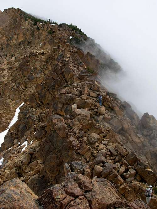
From the basin, we ascended the rocky west ridge of South Twin Sister and began our scramble ascent. I have done plenty of rock scrambles, but this was some of the most intense and elongated rock scrambling I had ever seen. I am not yet a rock climber, and I thought the experience would greatly enhance my experience level and comfort level for rocky ascents. As we ascended, it became increasingly clear that Edward, who was an expert rock climber, kept wanting to press ahead at a much faster rate than Gimpilator and I. At approximately 6000' elevation, we told him to continue on rather than wait for us. Edward neglected to bring a headlamp, so we figured this would optimize his chances for a successful summit while Gimpilator and I, who had headlamps, could continue at our pace.
![Ascending West Ridge...]() Edward and Gimpilator Ascend West Ridge...
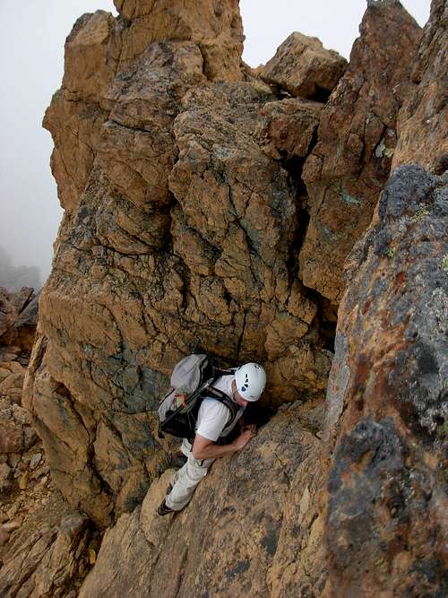
Edward and Gimpilator Ascend West Ridge...![Edward Earl In Action]() Edward Likes The Rocky Terrain...
Edward Likes The Rocky Terrain...
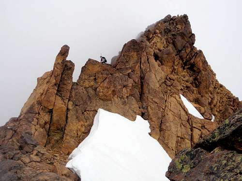
Gimpilator and I reached a small YDS Class IV rock wall at ~6200' elevation by 3:45 PM, prior to the false summit of South Twin Sister. We could see Edward nearly at the top of the false summit. Not wanting to slow him down but wanting him to have a good chance at summiting, I told Gimpilator to continue on without me, as I had already pushed my own rock comfort level on the trip and gained a ton of experience. For some people it comes naturally, but for me it is something that grows over time. I also know to trust my instincts. The spot I stopped was a nice flat rock nook that could be sheltered a little from wind, but from where I could watch Edward and Gimpilator continue their ascents (at least of the false summit). We briefly discussed scenarios and plans in case of different types of emergencies, and then Gimpilator continued his ascent.
![Gimpilator Makes A Move...]() Gimpilator Makes A Move...
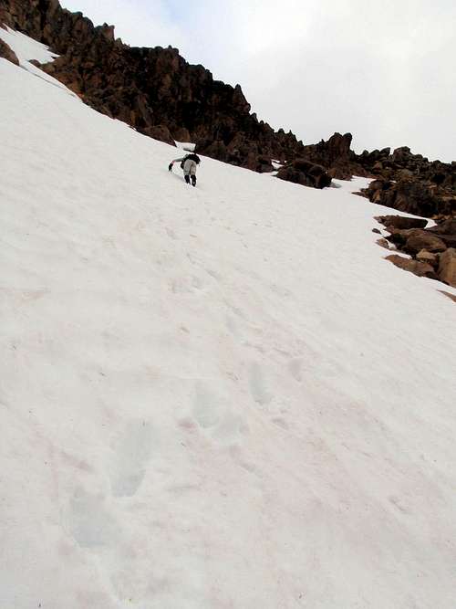
Gimpilator Makes A Move...![Turn Around Point]() Me, Staying Behind...
Me, Staying Behind...
After changing my layers of clothes to keep warm, I took some photos of Gimpilator and then lied down. I took a nap for 45 minutes, waking up in time to see both Edward and Gimpilator coming back over the false summit. Looking at the time, I knew they must not have summited. When they arrived back to my location, Edward told me he stopped an estimated 250'-300' vertical feet from the summit due to timing out, and then Gimpilator had met up with him only a few minutes later. I also found out the technical difficulty of the rocky ascent increased quite a bit, which helped verify my decision to stay back for that trip. Edward downgraded the entire ascent as YDS Class III, with possibly a few minor YDS Class IV sections, to which Gimpilator and I did not agree. Many rock climbers, by virtue of being very comfortable with rock climbing, tend to downgrade climbing ratings. Gimpilator and I knew this, and as a result knew the climb involved more than just a few minor YDS Class IV sections and moves.
![Gimpilator and Edward Descend...]() Edward and Gimpilator Descend False Summit...
Edward and Gimpilator Descend False Summit...
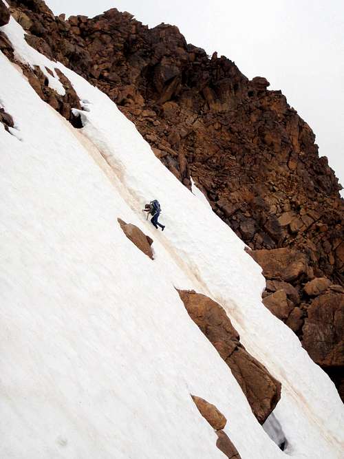
We descended the west ridge similarly to our ascent route, but chose to downclimb a steep snowy slope to the basin below us rather than scrambling down the entire ridge. This involved a different technical aspect to the descent, but a more enjoyable one. We eventually reached the basin, then the long rock gully, then the forest, and then our bikes. We cruised/coasted on our bikes back to our cars, arriving only 35 minutes from where we left our bikes... which had taken us two hours to travel/hike earlier that day.
![Edward Downclimbing]() Edward Downclimbs Steep Snow Alongside West Ridge...
Edward Downclimbs Steep Snow Alongside West Ridge...![Redwic Downclimbing]() Me, Downclimbing Steep Snow Alongside West Ridge...
Me, Downclimbing Steep Snow Alongside West Ridge...
While at the car, we ate dinner and made plans for the following day. Edward wanted to attempt Big Gee, another peak with over 2000' of prominence, but I had already heard enough about that mountain to know now would not be an optimum time to attempt it. I had mentioned to Adam about two other possibilities, Dock Butte and Round Mountain, so we decided to attempt those on Sunday, instead.
Two Squares Go In Circles
Late Saturday night, Gimpilator and I drove towards the Dock Butte Trailhead. While driving along the Baker Lake Highway, I briefly pulled over to put some extra clothes in the back seat. While standing there in the dark, with the car's headlights on, I opened my back driver's side door. Suddenly, I could hear at least one woman and one man saying, "Hey! Hey you! Wait up!" I could hear them running towards the car, but I did not know from which direction (the side or the back). I quickly jumped into the driver's seat and drove off. People running at me in the dark, with no flashlights, not saying anything like "Help me!"? No, thank you. Too bizarre. We soon passed a vehicle heading the opposite direction, so if those people did need help that car could possibly assist.
When we were approximately three miles from the trailhead, we encountered yet another unexpected issue. The road was blocked by several large snowdrifts... at only ~3400' elevation! It is July, and there was snow at 3400' elevation?!?!?! What a weird weather year western Washington has been having thus far. Disgruntled, we decided to not attempt Dock Butte. We turned the car around, drove a mile back, and found a nice wide flat area to park on the side of the road. Gimpilator setup a small bivy site, while I slept in the car. It was nearly 1:00 AM on Sunday, July 4.
I woke up at 5:00 AM, invigorated from a great four hours of deep sleep. Gimpilator, in contrast, woke up still very tired. We knew we needed to try to start as early as possible if we were to attempt Round Mountain, especially to try staying ahead of approaching questionable weather. Having watched the weekends plans change multiple times, and then having a failed attempt on South Twin Sister the previous day, and then not being able to reach the Dock Butte Trailhead due to snowpack, and then only having four hours of sleep, Gimpilator was a little cranky and unenthusiastic about our new Sunday plan. Fortunately, I had printouts of the Round Mountain route we were to attempt, so I remained optimistic about our chances on that peak.
![Gimpilator Hikes The New Round Mountain Trail]() Hiking West Along New Round Mountain Trail...
Hiking West Along New Round Mountain Trail...
We began our ascent via the New Round Mountain Trail, east of the mountain, by 8:25 AM. The unofficial, unmaintained trail was surprisingly easy to follow. This was because of the numerous flags/ribbons tied to trees, which we assumed ultimately helped lead others along the route and the amount of travelers on the route had made much of the path well-trodden and well-defined. We reached the snow basin at ~4500' elevation by 9:40 AM, and then began ascending up a mostly snow-covered talus slope towards the saddle east of the mountain. Reaching the east saddle (~4900' elevation) turned out to be a tactical error on our part, as the slope directly east of the summit (and west of the saddle) was a steep rock cliff. This meant we had to then side-traverse across steep snow and loose rocks until finding a gully that would lead us closer to the summit. At least our added trek allowed us to find some very fresh bear tracks in the snow.
![Gimpilator On East Saddle...]() Gimpilator At East Saddle Of Round Mountain...
Gimpilator At East Saddle Of Round Mountain...
We basically side-traversed along the mountain until on a snow-covered gully directly south of the summit. We ascended north until reaching the summit ridge, with the summit area nearby. We reached the summit at 11:10 AM, only 2h45m from the car, which we were satisfied with considering the bad snow and rock conditions and our extra traversing. The summit was marked with a rock cairn, although I made certain to touch several of the peak's highpoints. I found no summit register. With fog surrounding the peak and eliminating views, as well as its mist wetting the rocks around us, we spent little time on the summit area.
![Gimpilator Ascends Upper Gully...]() Gimpilator Ascends Upper South Gully...
Gimpilator Ascends Upper South Gully...
We carefully plunge-stepped snowy slopes down the upper south gully, then briefly side-traversed east until finding a more-direct walkable route back to the basin. We even found a few rock cairns along this route, so we knew others before us had followed the same general path. Gimpilator made several references to "only prominence baggers would want to summit this peak", to which I dismissed as probably not true. In my opinion, Round Mountain, if the weather allowed for outward views, would be well worth the ascent. Within a few minutes of Gimpilator's comment, we could hear voices coming from elsewhere within the basin. We called out to the people, to which they whistled, we whistled back, and then we had a very brief conversation. Due to the fog, we could not see them. They asked if we were ascending or descending, and then if we had made the summit. Then they asked if we were on the true standard summit route, to which I said we did not know but it worked for us. We do not know who those people were, but likely they were people we had heard of from online hiking websites... like us, they would be the most likely types of people crazy enough to attempt Round Mountain on a day like we were experiencing.
![Triumphant Redwic...]() Squarely Triumphant On Round Mountain Summit
Squarely Triumphant On Round Mountain Summit
We made it back to the car within 2h15m from the summit. Given the snow conditions and the freshly slick rock and dirt (from the fog mist), we were satisfied with our time. We were disappointed that we had only summited one peak in two days, but at least the peak we summited had some peakbagging significance. Round Mountain is the eighth-most prominent peak in Washington, and the CoGPP of Skagit County. Although it did not have the prestige of a South Twin Sister, and it required several changes of plans, we were still able to salvage our climbing time in some sort of capacity.
Comments
No comments posted yet.