Machame Route
There were seven in our party to climb Kilimanjaro by the Machame Route. My wife Dorthe was the one to declare we were going to do this. We soon recruited our regular hiking companion Jen (Lululuv on 14ers.com). Jeff, who we met on a mountain a few years ago signed on as well. Louise who we have traveled and climbed with in the past was almost the last to sign on. With the addition of Louise we now had three dental hygienists along! Our group became seven when Louise discovered one of her patients, Mike and his girlfriend Brenda were already planning to go at the same time.
We settled on Kessy Brothers Tours after researching prices and because Dorthe’s brother had used them a few years earlier. The price included picking us up at the airport, all accommodation in Tanzania, meals on the mountain and safari, and return to the airport at the end of the trip. In addition we had to budget for tips. Expenses we still had to cover included some restaurant meals in between tours along with additional drinks and snacks.
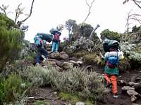
Sunday, Feb 8, 2009. Day one started for us at the Buffalo Hotel in Moshi. We had our stuff sorted into three categories. Stuff to stay at Kessy Brothers, stuff for the porters to carry, and what we would pack ourselves. We left the hotel at 9:30 and after a stop at Kessy Brothers office drove up to Machame gate. At the gate we signed in and also had our last opportunity for a nice bathroom for a week. At the start of the trail we were issued substantial box lunches. It was 11:30 by the time we actually started hiking up the trail. The starting elevation was 5952’/1814m. Our head guide Fredrick introduced us to Pauly who started out leading us. Fredrick would catch up later.
![Machame Camp]()
![Choo]()
We stopped for lunch at 2:30 at a site with a outhouse and a few small clearings for various groups to eat. elevation 7938’/2420m. We had some rain on the trail, but not enough to bother us. We brought plastic rain ponchos, which were roomy enough to cover our packs. We got to Machame Camp at around 5:00. elevation 9916’/3022m The tent areas were dirt and had a slick mud surface from the rain. As with each subsequent camp we signed a log book.
This camp was also our initiation into the nastiness of the choos (bathrooms.) I debated using this picture, but I know some people will just have to know. I hate to say, they got worse!
Meals
After getting settled in we gathered in the mess tent for supper. We were served by Eric, who would also be a guide on summit day. This first night was one of the nicest meals with zucchini soup, potatoes, stew, fish, cabbage, bananas, bread. There was always hot water to make tea, coffee or hot chocolate. The lunch on the trail included an egg burger and fried chicken. The next few nights the cook got on a curry kick. There was always plenty to eat, but on the third night of curry I poured hot water in a Mountain House meal instead. Fortunately he got over the curry thing for the rest of the trip. On the last night we were served a “traditional Chagga stew”. It was basically beef stew and was good. Breakfast always came with eggs, sausage, porridge, toasted bread and fruit. Actually I stopped noticing if there was porridge since I only ate it the first couple times.
Water
Our drinking water was boiled. Generally breakfast and dinner time were the opportunities to fill our containers. I recommend having at least one extra container to work with in addition to the ones you pack each day.
In general I’m accused of being a fussy eater because I’m not into hot spices or mystery foods, but I can say the food was pretty normal by western standards. We brought a lot of bars and gu and ended up giving most of them away. I only used one dehydrated meal I brought “just in case”. Summit day was the only time we really needed our bars and gu. I learned from one of the guides the group gets re-supplied along the way by porters that come up the trails we cross, so the meat you eat on the last day didn’t make whole journey with you.
Monday, Feb 9, 2009 Day two. I tripped over a muddy grass hump going to the choo in the middle of the night. My right side is stiff and I twanged my right triceps catching myself. We got going at 8:50 and had lunch at around 10,500’/3200m. We got to New Shira Camp at 1:45. elevation 12,609’/3743m. For this leg we followed Fredrick with Mate bringing up the rear. This would be the usual combination of guides the rest of the trip, except for summit day when we had four guides. It was foggy and drizzling at Shira so we passed on the side trip to Shira Huts. However Shira is not hopelessly slick muddy the way Machame Camp was. But the choos were nastier!
Tuesday, Feb 10, 2009 Day three. Our planned 8:00 start had us walking at 8:17 for what would be one of our biggest days. We got to the Lava Tower base at 12:15. 15,245’/4647m Mike, Jeff, Jen and myself climbed the Lava Tower 15,454’/4711m with Fredrick in the lead. The are some third class moves and a little bit of exposure in one spot. However the rock is solid with an abundance of holds and lots of texture for grip. The round trip took us about 40 minutes. We got back just in time for it to start raining. We traveled faster than at any other time following the guide and got to Barranco Camp at 3:00. elevation 13,065’/3982m As we travelled along the mountain more routes came together so the camps get bigger and the choos get nastier.
Wednesday, Feb 11, 2009 Day four. For people doing the six day plan this is a long day to Barafu Camp followed by leaving for the summit that night. We however were on the seven day plan. We got started at 9:30 and joined the conga line slowly lumbering up the Barranco Wall. If you have done any scrambling at all then the Barranco Wall is nothing to worry about. There are some third class moves but mostly you are working your way up a series of ledges. Although the fall line could be described as steep it doesn’t feel exposed. Often the porters are passing the hikers by scrambling up spots adjacent to the easiest way. For much of the climb our group was intermingled with a group from Sarnia Ontario. This proved to be fortuitous. Part way up a porter with another group was injured. He stumbled and smashed his finger against the rock. He was in a lot of pain. We stopped and helped him as much as we could with our first aid supplies. The Sarnia group had three doctors, so when we all got to the top of the wall one of them was found and examined the porter and rewrapped his hand. Fortunately he didn’t have any broken bones, but he was out of commission. We arrived at Karanga Camp at 1:20. elevation 13,157’/4010m Our guide Fredrick pointed out we started on the wetter side of the mountain and we have now moved around to where it is dryer. The last water is just before Karanga camp. Our porters will have to haul water from here to Barafu Camp.
![Approaching Barafu Camp]()
I had a tight head in the middle of the night and again some during the hike. It was another short day. My head felt better after arriving at Barafu camp. Elevation 15,193’/4631m. I supplied our guides with batteries for their headlamps. The batteries available locally go dead fairly fast.
Friday, Feb 13, 2009 Day six. We started getting ready around 11:00pm. At 11:30 we went over to the tent for some hot chocolate and cookies. We got going at 12:20am. In addition to our usual guides Fredrick and Mate we were joined by Pauly and Eric. Fredrick set the famous pole pole pace which successfully gets many clients to the summit. For a group of Colorado hikers this was the first day we would climb a lot higher than our fourteeners. By going pole pole instead of as fast as some of us would have tried, we avoided being at the edge of our breath. All seven of us were able to make it!
The first 600’ or couple hundred meters above camp are a steep stretch, then it levels out for a bit before getting serious about going up hill again. The trail splits in two with the uphill hugging the more solid rock on the left until Stella Point. elevation 18,886’/5756m. The downhill trail has a lot of heel sliding and is to the left coming down.
![Kilimanjaro Sunrise]()
![Stella Point]()
We got to Stella Point at around 6:15am. The sky to the east was starting to lighten. After gaining Stella Point the rest of the trip to the summit is physically much easier. There is one spot where the guides feel the need to watch you squeeze by some rock that steers you near the edge. For us the sun came up between Stella and the summit. I felt great! I kept scooting ahead of the group and would then stop to take pictures as they passed. I stopped short of the summit to wait for everyone. This was my most emotional moment since I knew how much this summit meant to Dorthe. When we went to Aconcagua she had to return to Mules after a couple sleepless nights at Nido. She also had to turn back on a couple of Andes peaks when she felt fine but couldn’t move fast enough to make the summit. It would have been huge blow if she hadn’t gotten this one. But instead here she was topping out on one of the seven summits!
![Kilimanjaro Summit Approach]()
![Descent below Stella]()
We got to the summit around 6:45 and stayed until around 7:15. It was quite a circus at the sign. While we were there more and more people arrived. With seven of us plus four guides there were various combinations of pictures with several cameras to take. You don’t get to be a wedding photographer about it. You get in position, push the button and clear the sign for the next photo. If you want more pictures just be ready to jump in another time. This was quite a contrast from Aconcagua when it was just myself and my partner having the summit to ourselves for an hour.
Although there were clouds below us it was clear sky above. The temperature was around freezing with a 10 to 20 MPH wind.
We got back down to Barafu Camp at 9:20am. It felt bizarre to be that early in the morning and back from the summit. We had a few hours to rest, eat, and pack up. We left Barafu at 1:18pm and took about 3 hours to hike down to Mweka Camp. Elevation 10,015’/3053m.
After we got settled in at camp I went back up to the ranger station with our four guides and bought them each a beer. They were interested in how we climb in the United States. They wondered things like if we don’t have guides, who will rescue us if we get hurt.
Saturday Feb 14, 2009 Day 7. Hike down to Mweka Gate. Elevation 5397’/1645m. We got up early to be on the trail at 7:30. The strategy was to get to the gate ahead of most of the other groups so we wouldn't have to wait to sign out. It took the predicted three hours to make the trip. After getting back to Moshi we stayed at the Zebra Hotel before heading off on safari the next day.
Tips
We distributed our tips that morning before leaving camp. The previous evening we got the tips ready in envelopes. Our group of seven had 21 porters who we gave $50 each. Our head guide got $105 + $20, second guide $91 + $20, guide $70 + $20, guide + server $70 + $14 + $20, cook $84. The + $20 after each guide is because on summit day they ended up carrying the packs of each of the women in our group, who then gave them each an extra $20! Note this is just the mountain tips – you will still need to allow tipping for safari and other tours.
Cost
We each paid Kessy Tours $2415. This broke down as $1325 for the mountain, $100 for village tour day and $990 for the 5 day, 4 night safari. It included 4 nights in hotels in Moshi and transportation from and to the airport. The only meals we bought were in Moshi in between tours.
Airfare
Instead of the usual KLM through Amsterdam we flew from Washington – Dulles on Ethiopian Airlines. This involved spending a night in Addis Ababa, Ethiopia before flying the rest of the way to JRO Kilimanjaro International Airport. We did this because we booked our flights just as the price of fuel went crazy last spring. The NWA-KLM option shot up in price, but Ethiopian Airlines stayed at around $1200. We bought a separate flight to Dulles the previous evening on United for $400. Even with hotels in Virginia and Addis Ababa we still came in much cheaper and inadvertently were more rested with the flying split up.
Visa
We did not have to pay for an Ethiopian visa since we were considered in transit. They stamped our next day boarding passes with a transit visa. On arrival in Tanzania we had to pay $100 for a visa . There was no departure tax. However they did look at our International Certificate of Vaccinations. I think they might have been checking for the Yellow Fever sticker.
Money
We found credit cards to be not a lot of use in Tanzania, however there are several ATMs in Moshi. When we were there the exchange was approximately 1300 shillings to a US dollar. US dollars are readily accepted and easily changed at money windows in Moshi. It’s best to have local currency for many cash transactions. If you don’t get local currency you’ll find something that cost 10,000 shillings tries to become $10! ATMs dispensed 10,000 shilling notes. There was the usual third world routine of people often not having enough change. I changed about $75 into $1 bills for the trip. Often having $1 bills avoided the disadvantaged position created when they can’t change your 10,000 shilling note. I also changed a few hundred into tens and fives to give flexibility when it came time to do tips and any other transactions where I chose to spend $US.
GPS Waypoints UTM WGS 84 elevations in feet and meters
measured with a Garmin eTrex basic yellow model
304342 9649046 5952 1814 37 M Machame Gate
307342 9657672 9916 3022 37 M Machame Camp
308460 9660824 12609 3743 37 M New Shira Camp
314137 9660778 15245 4647 37 M Lava Tower Base
314098 9660708 15454 4711 37 M Lava Tower Top
314287 9657760 13065 3982 37 M Barranco Camp
317091 9655748 13157 4010 37 M Karanga Camp
319840 9657176 15193 4631 37 M Barafu Camp
318035 9659630 18886 5756 37 M Stella Point
317078 9659818 19344 5896 37 M Summit
318479 9650828 10015 3053 37 M Mweke Camp
315674 9643980 5397 1645 37 M Mweke Gate
Map
For a map I ordered from http://www.climbing-map.com/en/maps/kilimanjaro.html
This map is 1:80,000 scale with a 2km UTM grid on WGS84. I used a straight edge to make it a 1km grid, labeled the grid within the map, highlighted the route, and numbered our camps. I then enlarged the upper mountain 2X on a color photocopier and used a freezer bag to protect the result. I also had a 1X copy showing a broader area. Since we were always with guides I didn’t need this for navigation but did like having it to refer to and match my location with the GPS.
Clothes
For summit day I had my Gortex jacket and pants, 2 pairs of fleece pants, long underwear, 2 fleece jackets, fleece undershirt, synthetic undershirt, fleece gloves, fleece mitts, Gortex mitts, Gortex hat, fleece neck gator, down jacket - which I put on higher up. Like most people I wore regular hiking boots instead of double mountaineering boots. I had another hat and neck gator in reserve which I didn’t need.
For most of the mountain I wore a pair of synthetic pants with zip off legs. These were able to take me through a wide range of temperatures. I wore gators. Those protected the tops of my boots and socks from getting mudding and dusty and also controlled the bottom of the pants which were kind of baggy on me. I traveled with a fleece jacket and a lighter shell jacket along with the rain poncho, fleece gloves and hats for sun and cold.


Comments
Post a Comment