Intro
Kilimanjaro, Tanzania
Uhuru Peak (19340 ft/5895 M)
Highest point in the continent of Africa
World Prominence Rank- 4
February 20-26, 2007
Via Rongai route
42.6 miles RT, 14140 ft gain
Participants: John & Kathy Mitchler, Tim Dalsaso, and Kevin Baker
Guides: Amani Zakayo Leikule & Winford Amani Mtui (aka Winfoot) with Zara Tours
Slideshow
Ever since I was a kid, I have been fascinated by someday climbing Kilimanjaro. My wife has pushed me the last few years to fulfill that dream, and the financial resources were finally there to live it. I didn’t decide to pull the trigger until October, so the hunt was on to find somebody to go with me. After a few weeks of fruitless invites, my friends John and Kathy Mitchler were seriously interested as long as Kathy’s brother Tim from Cambridge, MA could make it. After a yes from Tim, we booked a trek with
Zara Tours. We would not regret this decision as our guides were great for a very competitive price.
Since Whitney is the highest mountain I had climbed and I wasn’t sure how my body would react, I thought Kili would be a nice intro to high altitude. On Kili, you don’t have to worry about cooking meals or hefting a heavy pack as you have the luxury of having porters do the dirty work. Kili is one of the few mountains in the world above 19K’ that is considered a walk-up as there is a trail all the way to the top on most routes, although it should not be taken lightly. The success rate is around 50% as many underestimate the toll the extreme altitude takes on the body. To increase our odds, we picked the less traveled Rongai route from the north, considered by most to be the easiest route as it is not as steep. We also paid for an extra day to acclimate at Mawenzi Tarn at over 14K ft, which really paid off for us.
The trip to Tanzania is an adventure in itself as it usually involves 3 flights from the US, 2 of which were around 8 hours or so. We took separate flights from the US and met in Amsterdam, which is where most westerners are routed to on the way to Kilimanjaro International. We decided not to fly to Nairobi even though it is cheaper, because you then have a long bus ride to add to the long trek. Our flight arrived on time at around 9:45pm local time, a journey of 28.5 hours from when I left C. Springs. The journey home was even longer at 37.5 hours from when we left the hotel until I got home as I had a longer flight to Atlanta and a minor delay! By the time we cleared customs, loaded up our stuff on the Zara van, and arrived at the Springlands Hotel in Moshi it was around 11:30. The hotel was basic but pretty clean by Africa standards. A clean bed was all I needed to be happy! This hotel is gated and has such amenities as a gift shop, pool, massage services, and the internet.
Our first day in Africa was a recovery from jetlag day in which we visited a local school and hospital. John had a friend in the state highpointer’s club who had done some work for the Lyasomboro primary school in Marangu. We stopped by to donate some supplies and clothing and the principal let us visit a couple classrooms. This was a treat as they sang some songs for us, one of which was about mighty Kilimanjaro. We also stopped by the Moshi Hospital to drop off a medical kit that was donated by a former Zara client. We were fortunate to find a Zara employee by the name of Habibu who escorted us around town for a reasonable price. Before supper we met our guides Amani and Winford along with the cook. We quickly went over the specifics of the climb. Initially Winford said that our extra day would be broken up by only going to the second cave, but we straightened this out later on as we wanted to acclimate higher at Mawenzi Tarn. After a weird Chinese meal back at the hotel, we headed for bed.
Day 1
Day 1- Feb 20- Rongai TH (6600 ft) to Simba Camp (8750 ft) 3.9 miles, 2100 ft gain
3 hrs.
Temps: upper 70’s to mid-80’s (degrees F)
It was hard to believe this day had come. We were all excited to finally get on the trail and start hiking, but a long ride to the trailhead awaited us. We had a nice breakfast at the hotel and then checked in our stuff that we would be leaving at the hotel in storage. The view of Kili from the hotel was inspiring as it towered nearly 16000 ft above, the most vertical relief I have ever seen! We piled our packs and duffels in the van that we shared with a couple women from Toronto, Catherine and Toni. They too were doing the Rongai route, but over 6 days.
The Rongai route is not very popular because you have nearly a 3 hour drive to the trailhead. You can also claim being in Kenya as the road is the boundary for a brief stretch. We thought the ride was cool because we got to experience the local culture more. I would say 90% of the folks in Tanzania do not have cars or bikes, so they’re all on the roads going about their business. You’ll see women carrying bananas, water, chickens, and all sorts of food on their heads while some men are running down the streets with carts or riding bikes. There will be an occasional car or van, but they’re usually ferrying tourists around. Our driver did a great job weaving around the heavy activity on the roads, and it was pure entertainment. We stopped in the town of Naremoru just a few minutes from the trailhead for a sack lunch. We had to wait around for Catherine & Toni’s guide, so we stopped in at a local bar where John and Tim had a beer. After about an hour in this town, we made our way to the trailhead. Just before arriving, our van got stuck as we had to make way for a large truck. The porters along with Tim and myself helped push the van out and we finally arrived at the trailhead!
We checked in at the gate and waited around as our porters were divvying up the loads. The limit for each porter is 35 pounds, and all of our duffels or backpacks were well under that. It’s amazing what these guys can carry as many times they had more than one pack. Amani told us to start with Toni and Catherine’s guide Frankie, and we were finally off at 3pm. I checked my thermometer and it was 87 degrees F as we started, but that was a bit skewed by the sun. The Rongai route pretty much misses the rainforest and starts out in corn and potato fields for the first half of the hike before giving way to an alpine forest. Some of the local kids were following us for the first bit, which was cool. We were able to see our first Colobus monkeys about a mile up the trail as three or four of them were active in the trees. Frankie set a very slow pace, which was expected but hard to adjust to as it was probably 1/3 of the pace I am accustomed to. I knew it would pay off down the road on summit day. Pole Pole is the name of the game on Kili. We made it into Simba Camp just an hour or so before dusk.
We were very impressed with the basic meals we were served and really didn’t have any food related issues. The typical fare for breakfast was porridge, eggs, some sort of fruit, tea, sausage, and bread. They served a lot of fried foods for lunch and dinner with the main meat being chicken along with various soups, vegetables, fruits, and pastas. I know I ate a lot more fruits and vegetables here than I do at home. A couple times we had sack lunches along the trail. As a precaution, we treated our water and soups with Sweetwater (sodium hypochlorite) and/or a Steripen, a device that uses ultraviolet light to zap the bad stuff. Even though our water was boiled, we took this extra precaution since it is hard to fully boil water at altitude.
Day 2
Day 2- Feb 21- Simba Camp (8750 ft) to Kikelewa Cave (11811 ft) 7.9 miles, 3800 ft gain.
6 hrs, 10 min
Temps: low 40’s to upper 60’s
Today was our second toughest day of the trek, but it wasn’t too bad at all. I of course didn’t sleep well the first night as is usually the case when camping. We were the first to use a brand new set of Kelty Orb 3 two-man tents that were awesome as John & Kathy brought them from the travel agency in Boulder. There was plenty of space to put our daypacks inside with our big packs or duffels in the vestibule.
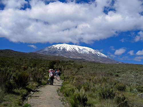
![Kibo view on Rongai route]() Glorious view of Kibo on day 2 of our trek.
Glorious view of Kibo on day 2 of our trek.
Today’s journey climbs gently through the moorland to the first and second caves. There were bits of steeper sections, but the trail was generally pretty mellow. We had lunch at the 2nd cave where some folks who opt for a 7th day spend the night here. Since this is still at a relatively low altitude, we felt it was best to have our rest day at Mawenzi Tarn at over 14K ft. From this point, the trail strikes to the southeast across undulating terrain to Kikelewa Cave, our stopping point for the day. Amani let John set the pace for much of the day, so we were able to maintain a little faster clip than the first day. At Kikelewa, we got our first views of formidable Mawenzi, the more impressive summit of Kilimanjaro and 3rd highest mountain in Africa. There would be far fewer folks attempting Mawenzi if it were the highpoint as it is a loose, dangerous mess.
Tim began to establish a nice rapport with the porters and a phrase that he likes to say became a dominant theme of the trek. He began responding to the porters and guides with “Yes, Boss”, which they got a kick out of. I did my best to learn a little Swahili, but
I only picked up a few words. The porters seemed to talk about anything and everything after dinner. I can’t imagine what there is to talk about for so long!
Day 3
Day 3- Feb 22- Kikelewa Camp (11811 ft) to Mawenzi Tarn (14206 ft) 3.2 miles, 2300 ft gain.
3 hrs, 10 min
Temps: mid 30’s to mid 60’s
This was by far the easiest day of the trek even though we were quickly gaining altitude. This was also probably the most scenic day as the inspiring ramparts of mighty Mawenzi beckon you to draw closer.
Mawenzi approach video
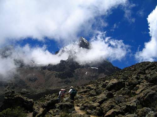
The trail gently climbs rolling terrain before coming to a prominent ridge that protects the camp at Mawenzi Tarn from high winds. The camp sits at the terminus of the moorland at the base of the rugged north slopes of Mawenzi. Clouds were playing hide and seek with Mawenzi at we approached, making for some spectacular scenery.
![View of Mawenzi from Mawenzi Tarn]() Mawenzi stands tall on the approach to camp.
Mawenzi stands tall on the approach to camp.[
Our guide Amani has climbed it, but he said there was a lot of loose rock in the gullies and he was roped in for the summit pitch. According to the map I bought, the northeast ridge offers an exposed class 3 scramble. John and I toyed with the idea of bagging one of the lower sub-summits as an acclimatization hike, but we figured it would be too much effort just to get to it at over 16K feet.
![Mawenzi towers above]() John and Amani approaching camp as Mawenzi looms.
John and Amani approaching camp as Mawenzi looms.
After lunch, we joined Frankie and another group for a short acclimatization hike to the n.w. ridge of Mawenzi where I set an altitude record at a bump at 14680 ft. So far, so good! I actually got a good 6 hours of sleep on this night, but that would be by far the most I would get for awhile.
Day 4 & 5
Day 4- Feb 23- acclimatization day at Mawenzi Tarn (14206 ft)
Today was a much needed rest day at Mawenzi Tarn. All of the other groups headed for Kibo Hut on this day, many of which were already suffering from the effects of altitude. Most of the groups we met were Europeans, and the altitude seemed to be getting to them quicker than us since we had the advantage of living and training in Colorado. Tim was holding up very well despite living at sea-level as he kept a consistent pace that paid off on summit day. We took another short two mile hike to the same ridge today. John sat this hike out as he got sick from presumably dehydration, but he was able to get some fluids into him and felt better the next day. I still had a normal appetite and was showing no ill effects thus far, so things were looking good. Tonight started a trend of three nights in a row with brief storms of graupel and rain and/or snow, but each time we were in our tents for the evening.
Day 5- Feb 24- Mawenzi Tarn (14206 ft) to Kibo Hut (15429 ft) 5.2 miles, 1850 ft gain 4 hours
Temps: low 30’s to upper 50’s
Today was an exciting day as we finally made our way over to the base of Kibo, crossing the lunar landscape saddle between Mawenzi and Kibo. There was only one group ahead of us today, so we had the trail to ourselves. Clouds blew in briefly as we climbed probably the steepest section of the trail to date, but we soon lost the elevation we gained and dipped down to 13800 feet before slowly climbing to Kibo Hut. The wind was blowing pretty steadily today, but not enough to be a problem. There isn’t a whole lot of places to rest along the trail as the landscape was reminiscent of Mauna Kea in Hawaii, a lonely alpine desert devoid of contrast. We had lunch at a cluster of rocks that provided shelter from the wind. Huge crows joined us looking for leftovers.
15K ft really didn’t feel any different than 12K ft for me as our pace was so slow that my breathing never really picked up until summit day. Amani continued to keep a consistent, slow pace that allowed me to stay hydrated. I felt pretty good as we arrived at Kibo Hut, a depressing, exposed place where the winds howl and sleep is precious. We arrived around 1:20pm, enough time to get our summit packs ready and take a short nap before an early dinner. We headed to bed around 6pm so we could try and get some sleep before an early 11pm wake up call. No more than an hour later, a storm blew through that dumped some snow and graupel for a few hours on and off. This made it impossible for me to sleep as I tossed and turned in anticipation of what the weather would be like. It would take some pretty serious weather to keep me off the summit, but we did have an extra day to make another attempt if necessary.
Kibo Hut videoDay 6-Summit Day!
Day 6- Feb 25- Summit Day-Part 1-Kibo Hut (15429 ft) to Uhuru Pk (19340 ft), back to Kibo Hut 5 miles RT, 3890 ft gain
10 hrs, 45 min
Temps: mid-teens to mid-20’s
11pm did not come soon enough and we were finally at the cusp of summit day. The storm let up just an hour or so before we woke up. We had some tea and cookies in the mess tent before finally heading out at 12:17am. It was 27 degrees as we started out with moderate winds. Throughout our trek, Amani was the only guide with us while hiking as Winford was usually with the porters. Today we had both with us along with Nestor who brought up the rear. I was amazed at the line of headlamps zigging up the scree slopes toward Gillman’s Pt. It looked like we would be sharing the trail with at least 100 other summit seekers, although it didn’t seem like there were a whole lot of folks ahead of us. The Southern Cross provided a nice backdrop to the monotonous drudgery that was in store for us.
Within a few minutes of starting, we got stuck behind a very slow couple with their guides. We were behind them for quite awhile and were making very slow progress. At this pace it would take us over 6 hours just to get to Gillman’s Pt! Amani finally got by them and we were able to pick up the pace a little. As we climbed higher, the winds picked up and some snow squalls blew in. My hands were starting to get pretty cold as my internal furnace wasn’t generating much heat at this pace. I made it a point to drink out of my Camelback every 15 minutes or so to keep the tube clear of ice. We took a very short break about an hour into the climb and began the game of leapfrog with other groups. We would pass groups and then be passed when we stopped, although I think we only had a couple planned stops.
As we climbed higher, the groups began to bunch up and the pace was dictated by the slowest person ahead. I felt like I was climbing Longs Peak on a busy summer weekend! I failed to have my balaclava readily available, so I had to bail off the trail and dig it out. It was now becoming apparent that even the easy tasks were accomplished much slower at this altitude. I had to stop another time and get my mittens out, but I found out later it was too late as the tip of my fingers got a touch of frostnip. As I write I still don’t have feeling back in the tips, but it’ll come back eventually. The wind was now probably gusting to 40 mph, but I now was comfortable. I think the twilight zone for me began at around 18K ft. I felt like I was going through the motions in a trance at times. The simple scrambling moves among the rocks below the rim were a little harder and I could tell my motor skills were not as sharp.
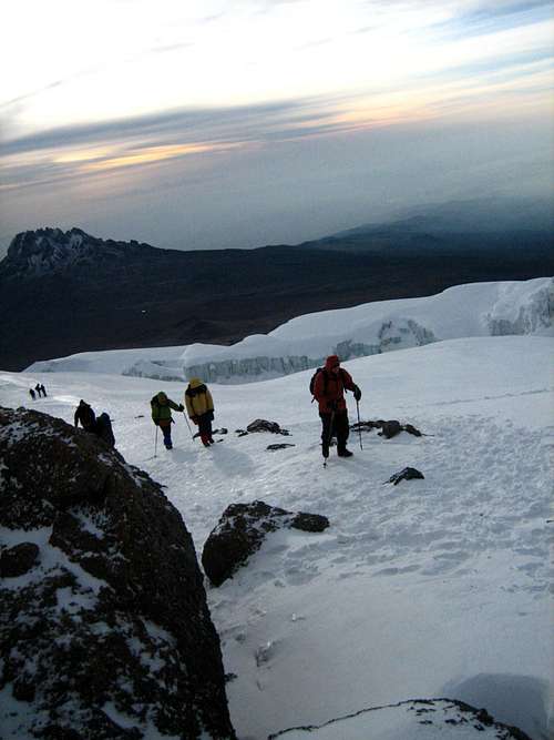
As we finally got close to the rim at Gillman’s Pt, the trail was backing up as folks were starting to struggle. We finally topped out on the rim at 5:40am with 30-40 of our closest friends. It was so crowded that we just bolted and headed for Uhuru. Our guide said that only about 20% of the people who make it to Gillman’s continue on to the highpoint, but on this day it was probably less due to the hard snow on the trail. I brought Yaktrax just for this section, but altitude-induced lethargy set in and I didn't put them on. We had to traverse some icy sections above some pretty steep snowfields that would be intimidating for people who aren’t experienced with steep snow. A fall here probably wouldn’t be fatal but it would be a long slide. Before continuing, I did get out my down coat as it was hard keeping my hands warm even with mittens. We slowly made our way across the icy sections as the wind was whipping about. We failed to mention to Kathy before the day started that it was an additional 2 hours from here to Uhuru Peak, the highpoint of Kilimanjaro. She wasn’t mentally prepared for this when Amani told her, so she decided to head back down with Winford around Stella Point.
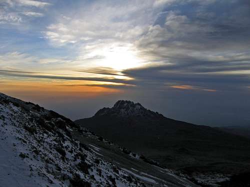
I really found it hard to believe that it would take that long to get over there, but it did. Hiking along the rim it was pretty flat with some undulating ups and downs. I made the mistake of trying to pick up the pace, but your body wants no part of that at this altitude. We slowly made progress and could now see the first false summit, Hans Meyer Pt. There seemed to be quite a few people coming up the Mweka route. We saw only 2 guys besides us coming over from Gillman’s. The views were amazing as the sun rose over Mawenzi and the glaciers were prominent, but I was focused on getting to the top and staying warm.
![Sunrise on Mawenzi]() Sunrise over Mawenzi from Stella Pt.
Sunrise over Mawenzi from Stella Pt.
Upward and onward we continued to Hans Meyer Pt, then over Elveda Pt until we finally saw the big sign!
![Aproaching the summit of Uhuru Peak]() Nearing the roof of Africa.
Nearing the roof of Africa.
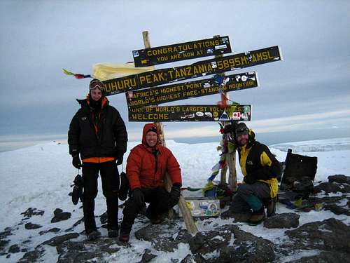
A few moments later we found ourselves hypoxically standing on the roof of Africa at 7:35am! Tim did very well for a flatlander and actually arrived a couple minutes before John and I. I dropped to my knees and said a quick prayer of thanks for the safety granted thus far. The summit seemed anti-climatic for me as we were rushed with summit photos.
![On the roof of Africa!]() Here we are finally at the summit!
Here we are finally at the summit!
The 18 minutes we were there seemed to blow by. I was going to pick up some rocks for each of my 14 nieces and nephews, but there was none to be found because of the hard snow. John broke out the US flag for a little patriotism and that was a special moment. We all hugged and headed back down.
![US flag on Kilimanjaro]() A little red, white, and blue on the summit.
A little red, white, and blue on the summit.
The slog back to Gillman’s Pt was taxing as I was winded even going downhill. We made it back across the icy sections without incident and took a break on Gillman’s Pt, arriving in about an hour and a half. I still didn’t feel like soaking up the views, which I now regret. I didn’t have any problems with the altitude, but I could tell my body was yearning for thicker air! Amani led us on a direct path down the soft scree that efficiently avoided the switchbacks. Normally I would have a blast scree surfing, but it was really difficult at this altitude. I stopped every couple minutes to catch my breath. We finally made it down to Kibo Hut at around 11am, an exhausting 11 hour day so far.
We took a much needed short nap back in the tents. I had packed all my stuff up thinking that the porters would take it down first thing, but my pack was still there. I just laid my head on my pack and dozed off. After some soup, we headed for Horombo Hut, a 6 mile journey tacked on to an already long day.
Part 2-Kibo Hut (15429 ft) to Horombo Hut (12204 ft) 6.2 miles
3 hrs.
Temps: low 50’s to upper 60’s
The trek down to Horombo Hut was not near as bad as I had feared. It had now turned into a nice afternoon and as we descended we all began to feel better and spirits were good. We made our way across the broad saddle as we were now descending the most popular trail, the Marangu route. A few groups were just arriving at Kibo as we left and they were anxious to hear how we fared. The trip down to Horombo at the edge of the moorland was uneventful but pleasant as the trail descended gently. We felt like we were back at sea level at 12K ft as the air seemed thick. Wish I could feel that way all the time. Everyone had a celebratory beer and I with my Orange Fanta as a long day came to an end.
Day 7 & Conclusion
Day 7- Feb 26- Horombu Hut (12204 ft) to Marangu Trailhead (5905 ft) 11.2 miles, 200 ft gain
5 hrs, 15 min
Temps: upper 40’s to mid 70’s
![Senecio Kilmanjari]() Senecio kilimanjari trees below Horombu camp.
Senecio kilimanjari trees below Horombu camp.
Today we finally got to see the rain forest and it did not disappoint. We came across several groups on this day heading up the most popular trail, most of which were in good spirits early in their journey. I counted 100 hikers on this day, much more than the numbers on the Rongai route. The first half of the hike is in the beautiful moorland zone. It seems to be a bit lusher on this side of the mountain. We stopped for lunch at Mandara Hut, which is the place most folks stay on their first night on the Marangu route. We chatted with some folks from Colorado there.
The trek through the rain forest went quick as we were eager to get back to the hotel. The trail was in excellent shape. I had feared it would be muddy with the recent rains, but that wasn’t the case. If you have strong ankles, you can easily get by with trail runners all the way to the high camps during the dry seasons. My North Face trail runners did well and I had no problems with blisters.
The final few miles were very pleasant as a brief shower passed by. We saw a few more monkeys in the trees, but they were obscured too much to get a clear shot. We made it to the gate at 1:10pm, just before a downpour started. It looks like we scheduled this trip exactly at the right time, as the monsoons were gaining steam at the end of our trip. We waited around for an hour or so before getting our summit certificates at the gate. We parted ways with Amani and Winford at the hotel after giving them tips for themselves and the porters along with some gear that we brought. We celebrated that evening at a nice pizza place in Moshi. Our last day in Africa was spent getting a massage at the hotel and shopping around in Moshi.
Conclusion
All in all, I think this trip couldn’t have gone much better. Our head guide Amani has been guiding since 1984 I believe and he said our group was the best he has guided, which meant a lot since he led former US president Jimmy Carter to the top! We had no problems with Zara and highly recommend their services. The land costs are middle of the road and I can’t imagine what else you get with the high end guides that charge up to three times as much!
As for medications, the only med I took was malaria pills. We all got by without Diamox since we took a full 6 days to reach the summit. As for shots, the ones that I was advised to get were Yellow fever, typhoid fever, polio, tetanus, flu, and Hep A & B.
It was an awesome journey to the roof of Africa with our guides Amani and Winford. I would highly recommend them. As for the difficulty of Kili, it shouldn’t be underestimated. The days leading to the summit were easy for me, but the time I spent above 18K’ was tough. I have felt worse at the end of some long multiple peak death marches here in Colorado, but the trek to the summit from Gillman’s Pt was pretty challenging. My advice is Pole Pole "polee polee", watch what you eat, drink more than you think, and soak up the views on the rim even though you don’t feel great!





Comments
Post a Comment