
-
 18254 Hits
-
 91.14% Score
-
 34 Votes
|
|
Area/Range |
|---|---|
|
|
37.91928°N / 14.00894°E |
|
|
Hiking, Scrambling |
|
|
Spring, Summer, Fall, Winter |
|
|
6493 ft / 1979 m |
|
|
1 - Overview
|
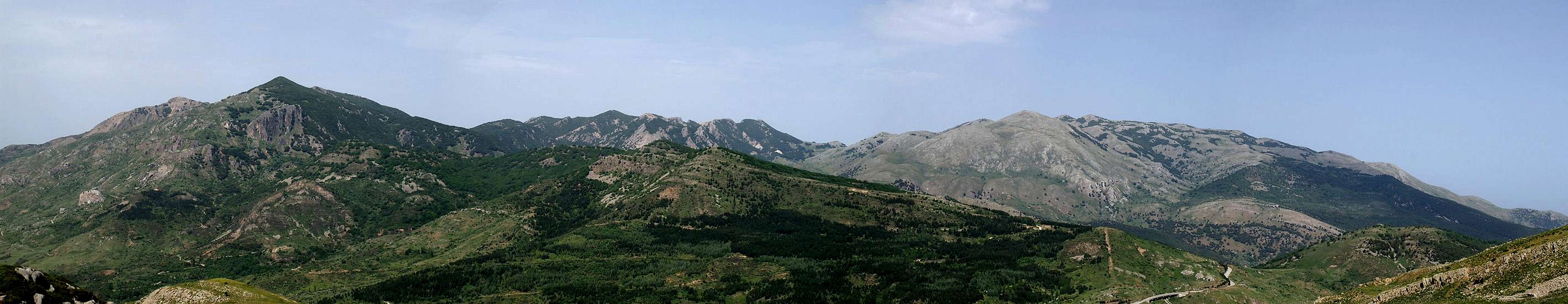
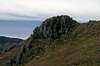
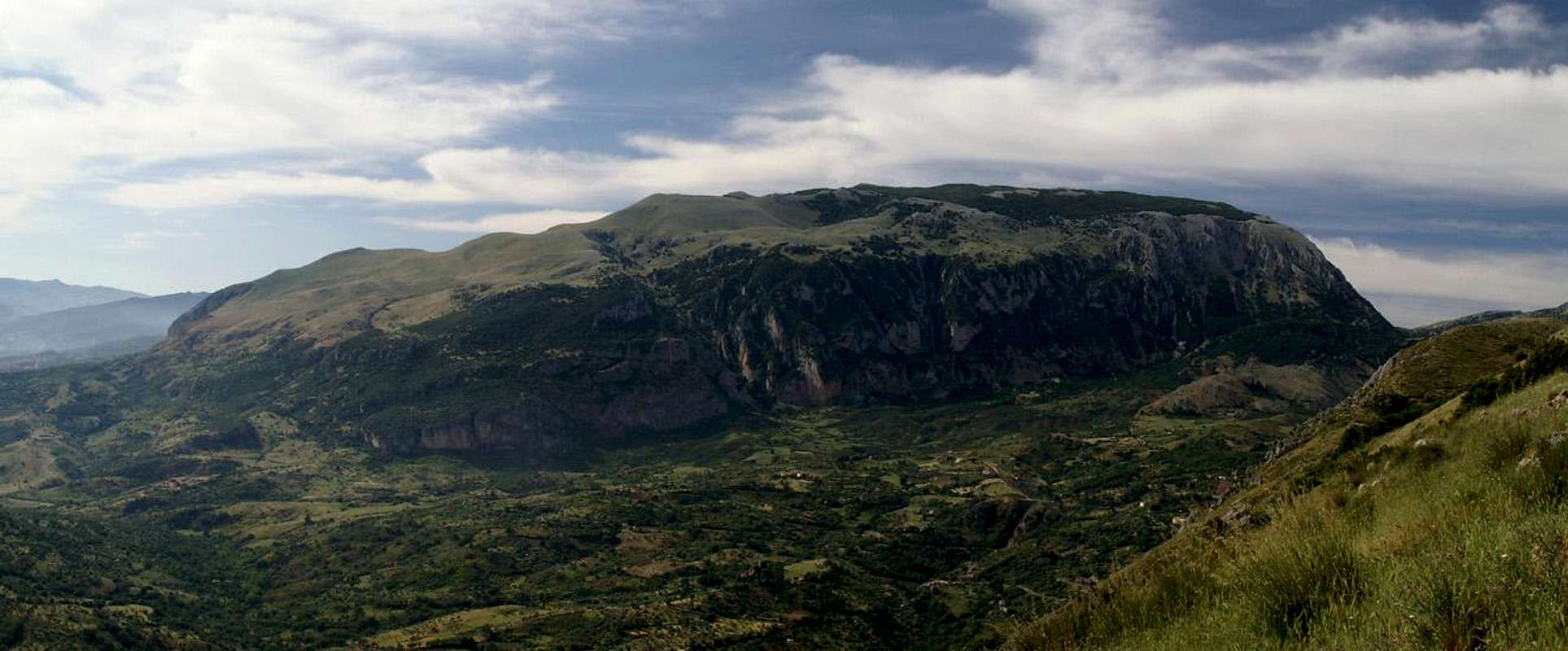
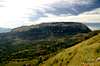
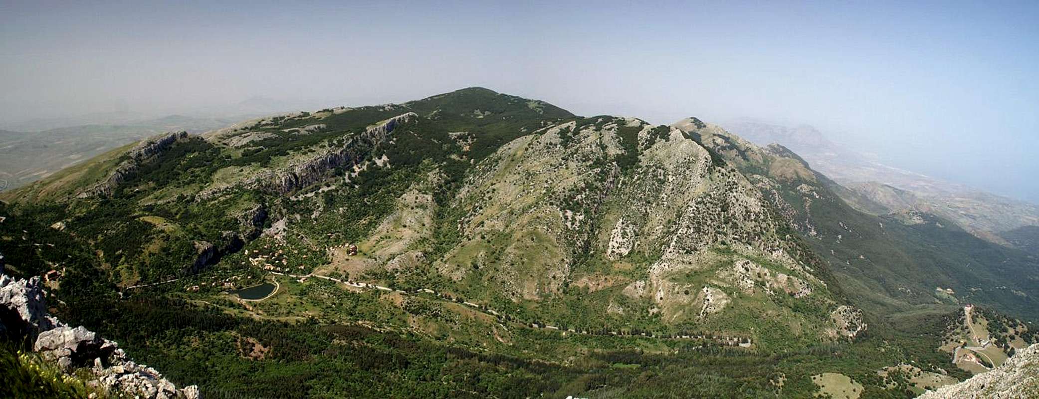
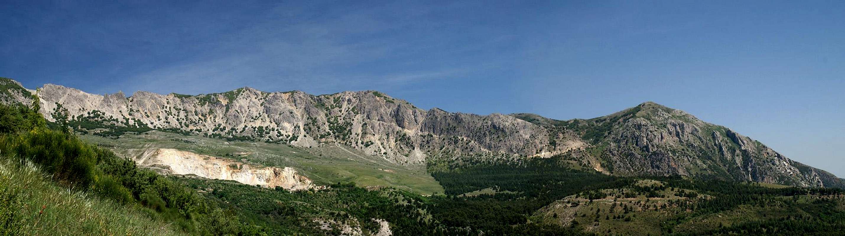
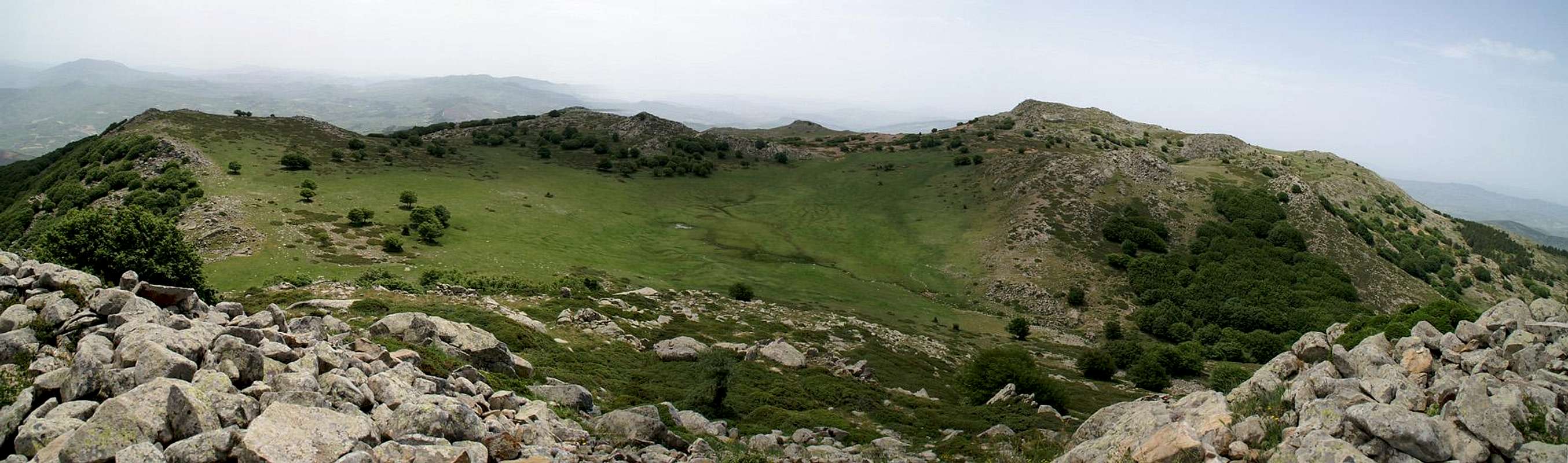
When it comes to Sicily’s mountains, everybody knows Monte Etna, Europe’s highest and most active volcano. Few people, however, know that the whole north of the island is composed of a long mountain chain, which separates into the three ranges, the Monti Peloritani, the Monti Nebrodi and Le Madonie. If it weren’t for Monte Etna Le Madonie would contain the highest mountains of the island of Sicily. Pizzo Carbonara, the highest one, possesses several equally sized summits, the highest of which reaches 1979m. The range is composed of limestone summits, all of which have karst-like summit plateaus. There are caves and canyons but the most distinguishing features are dolines, hollows which were created by collapsing caves and which accumulated enough soil to form beautiful meadows. The area is arid since all water vanishes quickly to the inside of the rocks only to spring out again at the base of the mountains.
The Madonie Range is divided into several subgroups which all are separated by profound valleys. In its centre the range is very compact, the Carbonara, Mufara and San Salvatore subgroups are divided by high saddles only. There are mountain roads all through the range which offer easy access to most of the summits. Thanks to the more or less featureless terrain near the summits, however, orientation can be very difficult. Quite often access is granted only through large patches of dwarf pines which surround and fill mighty dolines and which more often than not force large detours. Also, you should avoid the mountains in foggy conditions and any coastal breeze can turn into a full force storm among the mountaintops.
In the north Le Madonie starts directly on the north coast with the coastal ranges, the most easily accessible mountains of the group. Towards the south it continuously rises until the final drops to the central Sicilian highlands. In the centre a couple of profound valleys run through Le Madonie, the most impressive one at Isnello between the Carbonara and Dipilo Groups. While most summits are flat or rounded, the subgroups form impressive vertical walls on some of their sides, which - in the case of Isnello - rise some 800m to the east and west.
Le Madonie has a lot in common with the mountain ranges of Crete – Levka Ori, Oros Idi, Oros Dikti. All share the same composition and thus are very similar in their aspects. Karst plateaus, caves, dolines and gorges – you can find them all. However, the Madonie Range appears to be older, lower, more eroded. The gorges are short, wide and low, often accessible only across fields of debris, the mountains are rounded with vegetation right to their tops. The rocks are sharp edged, making hiking and scrambling a real pain. In several places you find bizarre rock structures, mainly in the Mufara Group in the centre of the range.
2 - Le Madonie on SP

 |
The Madonie Range can be divided into 8 groups of varying size, elevation and significance. The central part of the range is quite compact so that boundaries may seem a bit arbitrary, the northern and eastern parts are somewhat loosely connected only. This is especially true for the Sciara Group, which is separated from the remainder of the range by the large Imera Valley. The following list directs you to the subgroup sections and the mountains located therein.
3 - Madonie Coastal Ranges
 La Rocca di Cefalu
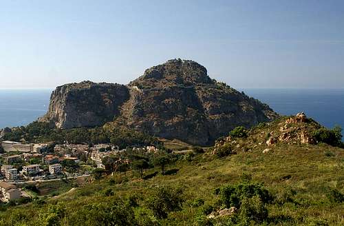
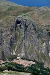
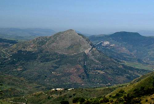
In the northern part of Le Madonie the mountains rise directly out of the sea. While to the west the Imera plain comes to an end in the centre and east few canyons head out from the mountains to the sea. Apart from that you have rocky cliffs right at the shore. The most impressive features of the subrange are Rocca di Cefalu in the north and Pizzo Sant’Angelo at its far south end. La Rocca is a circular rock of almost 300m height, which rises above the old city of Cefalu, directly above the sea. For ages it has hosted the castles of all the conquerors of the town – and there have been many. Pizzo Sant’Angelo is a sharp peaked mountain in the very south of the group best known for the Gibilmanna Sanctuary on its west slopes and the Chiesetta San Michele Arcangelo on its very top.
- La Rocca di Cefalù (276m)
- Cozzo San Elia (354m)
- Cozzo Spezi (347m)
- Serra Guanieri (397m)
- Cozzo Mastro Nunzio (410m)
- Cozzo Croceata (474m)
- Cozzo San Biagio (498m)
- Serra delle Dise (524m)
- Cozzo Rotondo (395m)
- Cozzo Monico (305m)
- Cozzo Cicerata (500m
- Le Serre (576m)
- Cozzo Captaro (605m)
- Cozzo Sellita (671m)
- Rocca Stefana (694m)
- Pizzo Giurafelle (793m)
- Pizzo Sant’Angelo (1081m)
![]()
- Cozzo Caracello (458m)
- Rocca San Nicola (665m)
- Cozzo Montenero (425m)
- Cozzo Quattro Finaite (587m)
- Cozzo Zurrica (589m)
- Cozzo Triari (698m)
- Cozzo Castellaro (927m)
- Cozzo Giampetra (856m)

4 - Dipilo Group
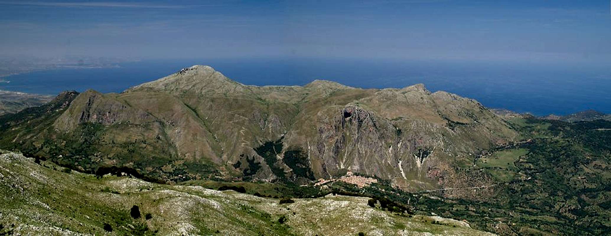 |
Pizzo Dipilo is the highest summit of its little group, a subgroup of the Madonie mountain range in Sicily. The group is a hilly high plateau, out of which several notable summits rise. The subgroup is located in the northwest of Le Madonie, far away from the higher mountains of the group so that any of its summits offer fine views to the coast and into the Madonie range itself. Famous is its eastern aspect, when seen from the Carbonara Group. The high plateau – and most notably Monte Grotta Grande – towers above the town of Isnello – vertically. The haigh plateau is used for cattle grazing and all mountains of the group are easily accessible. However you have to take the sharp edged rocks and macchia like bushes into account.
- Monte Macabubbo (1204m)
![]()
- Monte Puraccia (1157m)
![]()
- Pizzo Punti (1200m)
![]()
- Serra Arcia (1024m)
- Rocca del Monaco (805m)
- Monte Grotta Grande (1064m)
![]()
- Pizzo dell’Occhio (1189m)
![]()
- Pizzo Dipilo (1385m)
![]()
- Pizzo Giammarusa (1064m)
- Cozzo Medie (1188m)


5 - Carbonara Massif
 |
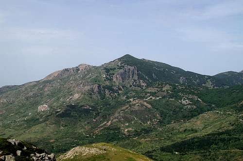
Pizzo Carbonara is the highest mountain of Le Madonie and fittingly it is at the centre of the largest subgroup of the range. Several of its summits reach more than 1900m though none of them reach 2000m. To the east and west massive vertical faces form an end to the sloped high plateau of the Carbonara Group. The plateau itself is rugged – lots of dolines block the way. An ascent of any of the major peaks can only be done in freestyle fashion as there are no paths across the rocky wilderness. The range is home to the last Sicilian eagles and in spring you can find lots of orchids in the crags and crannies of the karst.
- Cozzo San Giovanni (714m)
- Cozzo Cirino (1034m)
- Cozzo Trigna (1235m)
- Serra Circio (1671m)
- Monte Milocco (1235m)
- Croce dei Monticelli (1612m)
![]()
- Cozzo Luminario (1512m)
![]()
- Pizzo Stefano (1578m)
- Monte Ferro (1906m)
- Pizzo Praina (1808m)
![]()
- Pizzo Colsio (1876m)
- Pizzo Antenna della Principessa (1977m)
- Pizzo Carbonara (1979m)
![]()
- Pizzo Palermo (1964m)
- Pizzo Colonazzo (1903m)
- Rocca Gonato (1145m)
- Pizzo Stefano (1578m)
- Pizzo Canna (1429m)
- Monte Ferro (1906m)
- Monte Spina Puci (1737m)
- Cozzo Pomieri (1346m)


6 - Monte dei Cervi Group
 |
Monte dei Cervi and its group are located in the west of the Madonne Range, high above the Imera Valley. It also is a very large group, separated from the remainder of the range by SP119, the mountain road which runs across Le Madonie from Cefalu in the north to Polizzi Generosa in its south. It is famous for its two canyons, Vallone Inferno and La Padella, both of which lead to the Monte dei Cervi Summit. La Padella, when seen from Polizzi Generosa, looks like a giant pan, complete with a narrow handle.
- Pizzo Cerro (933m)
- Cozzo Alloro (949m)
- Pigio Grotta de Signore (898m)
- Monte Cucullo (1476m)
- Timpa dei Filici (862m)
- Rocca Palumma (981m)
- Cozzo di Tasso (807m)
- Monte Carca (1364m)
- Monte Castellano (1656m)
- Pizzo Antenna (1697m)
- Cozzo Morto (1611m)
- Pizzo Colla (1676m)
- Monte dei Cervi (1794m)
![]()
- Cozzo Piombino (1620m)
![]()
- Cozzo Cerasa (1687m)
- Cozzo Rituro (1507m)
- Monte Fanusi (1472m)
- Cozzo di Castellazzo (1446m)
- Punta Minieri (1192m)
- Cozzo del Fico (898m)


7 - Mufara Group
 |
Wedged between the large Carbonara and San Salvatore Groups there is the small subgroup of Monte Mufara. It is a north-south running chain, towering high above SP119, the road which leads from Cefalu to Polizzi Generosa. It shows rugged, sometimes bizarre, west faces – of almost dolomite like character. Monte Mufara itself is home to Sicily’s only ski run away from the Monte Etna’s south face.
- Monte Mufara (1865m)
![]()
- Monte Zuacalla (1869m)
![]()
- Monte Daino (1786m)
![]()
- Monte Scalone (1634m)
![]()


8 - San Salvatore Group
 Madonna dell'Alto (1819m), Monte San Salvatore (1913m)
The southernmost of the subgroups is named after its highest mountain, Monte San Salvatore. Like its counterparts the coastal ranges, the San Salvatore subgroup is rather well visited with mountain roads which lead up to its summits. Monte San Salvatore itself has a radio station on one of its fore summits, to which a rugged mountain road leads. Its neighbour, Madonna dell’Alto is named after the pilgrimage chapel on its top and sees many visitors during the year. In any other respect the San Salvatore Group resembles the Monte dei Cervi Group quite closely.
- Monte Pene (1665m)
- Monte Cavallo (1751m)
- Monte Rotola Vecchia (1205m)
- Cozzo Morio (1165m)
- Rocche del Pomo (1469m)
- Cozzo Cofino (1236m)
- Rocca Vaccaro (1438m)
- Pizzo di Sant’Otiero (1323m)
- Pizzo di Sant’Oliero (1547m)
- Pizzo dell’Inferno (1712m)
- Monte San Salvatore (1912m)
![]()
- Madonna dell’Alto (1819m)
![]()
- Cozzo del Filatore (1693m)
- Cozzo Girono (1630m)
- Cozzo Lampo (1538m)
- Cozzo Cacarelle (1392m)
- Pizzo Cerasa (1559m)


9 - Catarinecci Plateau
 |
To the east of the Madonne Range, above the town of Geraci Siculo, there is a large plateau, named after its highest summit, Pizzo Catarinecci. It stands apart from the other subgroups separated by profound valleys from the San Salvatore and Carbonara Groups. To all sides the plateau drops of almost vertically but on top you find the most picturesque of mountain meadows, Contrada Trentamazze. The contrada is enclosed by the mountains of the group and offers superb views of the remainder of the Madonie Range in the west. The plateau is used for sheep grazing so that - at any time of the year – you’re bound to find their flocks up there.
- Pizzo Argentiera (1496m)
- Cozzo di Raimonda (1574m)
![]()
- Pizzo Catarinecci (1660m)
![]()
- Cozzo Ipsi (1628m)
- Pizzo di Corvo (1657m)
![]()
- Cozzo Sconchipani (1240m)
- Cozzo Castellano (1156m)
- Cozzo Biancho (1116m)


10 - Sciara Group
 Rocca di Sciara
Now for something special: the Sciara Group, named after Rocca di Sciara, a standalone piece or rock, separated from the remainder of Le Madonie by the profound and wide Imera Valley. This group basically consists of Rocca di Sciara with two or three satellites and a handful of lower hills which surround it. The Rocca is tough to ascend, steep on all sides, with macchia undergrowth all around. It beautifully marks the transition from the rather compact Madonie Range to the western Sicilian highlands, where standalone rocks are the rule.
- Cozzo Cerilo (480m)
- Cozzo Cammarone (649m)
- Rocca di Sciara (1080m)
- Cozzo Rosso (719m)
- Cozzo Ebreo (782m)
- Pizzo St Angelo (606m)
- Monte Riparato (308m)
- Cozzo Capraria (435m)
- Cozzo Piano Gennaio (296m)
- Cozzo Monte Cibello (309m)
11 - Getting There
Sicily can be reached from all Italian and the major European airports by plane. There are two large international airports, one at Catania in the east and one at Palermo in the north. The cities are connected by motorways, which run directly underneath the Madonie south, west and north faces.11.1 From Catania
- Take motorway A19, direction Palermo.
- It will take you to Enna, then turn northward until you reach the Imera Valley.
- To your right (east) the massive west faces of the Monte dei Cervi and Monte San Salvatore Groups rise skywards.
- Either get off at the exit Scilatto for the south of the range or head northward to the intersection with A20 to Messina.
- Follow A20 to Cefalu or Castelbuono for the northern and western parts of the range
11.2 From Palermo
- Take motorway A29 direction Palermo
- In Palermo the motorway turns into a four laned city highway which circles the city to its south
- At the intersection with A19 and A20 take A19 direction Catania for the south-west of the Range using the exit Scilatto
- Take A20 for the north end east of the range, using the exits Cefalu or Castelbuono
12 - Accommodation
You can quite easily find hotel rooms and apartments everywhere on the coasts. All European travel companies offer accommodation so a visit to your nearest travel office will find you some. In the mountains themselves accommodation is much harder to come by. Since camping is not allowed (see red tape) you have to ask at the local inns. Moreover there are some farms which offer “agriturismo” though on Sicily this often means only food and no rooms.There are a few huts in the range, most notably Rifugio Crispi in the very east of Le Madonie, near Castelbuono. Also you can find hotels and restaurants at both Piano Battaglia and Piano Zucchi high in the mountains.
13 - Red Tape
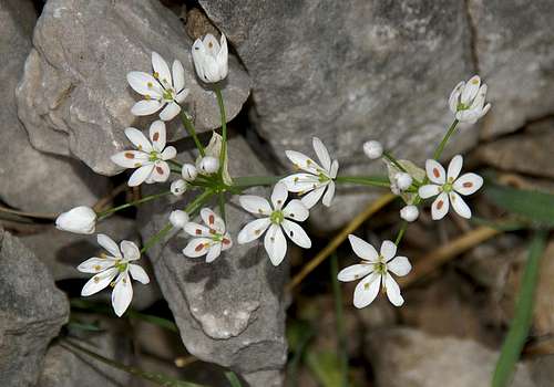 Allium subhirsutum
Most of the area of Le Madonie belongs to the Parco delle Madonie, which was established in 1989 and covers an area of approximately 40000ha. In the Sicilian parks you can climb and hike almost everywhere. Obstacles are the many barbed wire fences, which however can be crossed. They serve only for the pastures and to keep cattle sheep and horses from getting lost in the vast terrain.
Camping is not tolerated in the park, better look for accommodation in the nearby towns and villages. There are only few villages in the southern part of the range but north of the Carbonara Massif and to the east and west of the range you can find lots of inns. The northern coast of Sicily also is close by and there you will be able to find all kinds of accommodation (see above).
14 - Weather Conditions
Sicily is located very close to northern Africa (Marsala on the west coast is closer to Tunis than to any place on the Italian mainland), thus temperatures can get very high. March, April and early May are the best months if you plan to hike the mountains, the winter can be wet, the summer scorchingly hot. Here are a few weatherunderground links to the principal towns on the island. The closest ones are Palermo and Enna.15 - Maps & Books
15.1 - Maps
Unfortunately there are no current topographic maps of Sicily. The best are reported to be more than 50 years old and probably are the same as the basis for the digital maps of http://www.pcn.minambiente.it/GN/index.php?lan=en.
As a workaround you can use street maps for general orientation together with a good guidebook (see below). The most accurate maps are scaled 1:200000, sometimes detailing everything down to forest and dirt roads through the mountains. I settled for
- Sizilien
Shell Generalkarte
1:200000
Mairs Geographischer Verlag
ISBN: 3-8297-2080-7
15. 2 - Books
Since there are no good topographical maps of Sicily you should take care to get a good guidebook. The one I used is in general excellent. However it was issued in 2002 and in the 4 years that lie in between trail conditions have changed decidedly. The book is available in German and English.
- Sizilien / Sicily
M. Omidvar
Rother Verlag
ISBN:
3-7633-4266-4 (German)
3-7633-4813-1 (English)