LIBERTY CAP TRAIL
![User Profile Image]() Klover Wells in front of the Cap.
Klover Wells in front of the Cap.The Signature hike of the Grand Valley.
The Liberty Cap Trailhead is the start of many adventures that entail awesome views and hard work to reach them. The Liberty Cap trail is a very rocky and challenging hike that affords a rapid ascent of the Monument’s upper walls to the summit dome called the Liberty Cap. It is supposedly a three mile or two hour round trip but can feel much longer. In my humble opinion the Liberty Cap provides for the best view in the valley combined with the most interesting trail features along the way.
The trail starts out across the rolling desert prairie foothills and ascends behind a white hogback of sandstone rock that leans against the Black Rock Bench. After grinding up the cleft behind the hogback, the trail takes steep loose dirt and scree slopes to the bench above and a trail trial sign giving several options of exploration. The Liberty Cap trail ascends a half-mile higher traversing, twisting and turning to the Liberty Cap formation which sits atop the exposed rock bench like a proud Hershey’s Kiss that refuses to melt.
The cap is surmounted by climbing a short fifteen-foot cliff on the back of the dome via iron rungs bolted to the rock accompanied by rock steps. This antique feature is exemplary of John Otto’s (the early 1900’s developer of the Monument) trail building style that aims to take visitors to the top of the rims and even to the top of towers that otherwise would have been impossible. This is in tradition of classic routes in other National Parks in the states and the Kletterstieg and Via Ferrata climbing routes in Europe.
The hard won view from this classic rock summit is always a breathtaking affair. The Cap is like a gate dividing two worlds. The vast and developed Grand Valley lies to the North while to the South the elevated desert floor of Ute Canyon echoes with the call of the Canyon Wren. A green expanse of sage, pine and juniper lies between the layered rock walls that shift color from gold in the morning, to white in the afternoon, and burn red as the sun reluctantly retires.
From this rare vantage the activities of birds are no longer a mystery. You can feel the watchful eye of highflying eagles, falcons and ravens; get dizzy from watching swallows ride the ripping winds that scour the exposed cap; or witness swirling birds ascend thermals while gorging on clouds of insect. Soak up the nature then head back to town on the steep trail refreshed by the feeling of desert glow and the purity of blue sky.
There are many other trails to explore in this area. The Ute Canyon Trail is a great long day excursion that is a fairly gentle fourteen mile out and back tour highlighted by vertical wall arches, tall rock spires, shady potholes, cottonwood groves, and even cattail swamps juxtapose the seemingly lifeless walls. The Upper Liberty Cap Trail is another fourteen mile round trip that travels to top of the plateau above the rim to Rim Rock Drive via an old dirt road. I prefer cross country skiing down from the top after a good winter snow, as it gets too hot to be exposed for long with limited scenery to compensate for the effort.
There is an exciting newly reopened Corkscrew Trail that provides a nice short loop hike from the lower trailhead. It is most easily accessed by heading East on the Ute Canyon Trial about an eighth of a mile from the sign at the bench. Watch for a trail to the left just as the main trail starts to round the rock buttress that holds the Liberty Cap above. This “new” trail provides a smoother, less bruising and shadier alternative for a descent as it fittingly corkscrews toward the dark cliffs of Lower Ute Canyon. Rather than return to its original start at Buffalo Drive, the trail now trends to the old buffalo fence then loosely mirrors the park boundary back to the parking lot.
My fascination with Monument scrambling and seeking out John Otto’s visionary but now defunct scrambling routes began here. On the Western walls up canyon from the Liberty Cap hide several Ute and Otto climbing routes that gain the upper rim through natural weaknesses in the cliffs using small chopped steps, leaning logs, hanging wires, and iron pegs. There are many of such routes throughout the Monument that provide thrilling scrambling but require great caution.
Wanna Go?
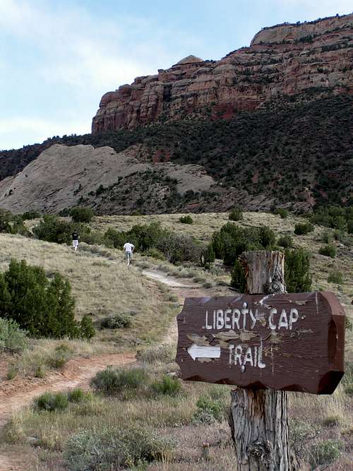
![User Profile Image]() signage, the Cap looms on the rim a bove.
signage, the Cap looms on the rim a bove.The Liberty Cap Trailhead is reached from Grand Junction by heading West on Grand Avenue and continue Broadway to the Redlands. Take a left which takes you south on South Broadway. Go about 100 yards past the Rigg’s Hill parking lot to take a Left onto Wildwood Drive. A few corners up this road brings you to the well signed and usually lonely trailhead on the right.
Resources
![User Profile Image]() the cap with quiet visitors
the cap with quiet visitorsNot much resource needed for Liberty Cap Trail as the trails are easily followed. Further exploration of the trails listed above would be easier and safer with a knowledgeable friend to point the way. I recommend bringing a quart or two of water and perhaps a light jacket for sitting on the cap in the wind. This area can become quite hot so avoid sunburn and heat exhaustion. The sun sets early behind the cliffs so can be shady late in the day.
![User Profile Image]() ladies going down the narrow ledge chopped by John Otto.
ladies going down the narrow ledge chopped by John Otto.![User Profile Image]() cap view...close to civilation and yet so far.
cap view...close to civilation and yet so far.


Comments
Post a Comment