
-
 10260 Hits
-
 74.01% Score
-
 4 Votes
|
|
List |
|---|---|
|
|
Summit List (8,500' - 8,999')
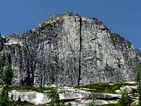
Castle Crag
Photo By Ben Johnson
Even though the peaks in the following list have summits with lower elevations than some, that does not mean they should be considered to be inferior or taken lightly. This directory contains more than a few peaks which are more technical, remote, and difficult to climb than some of the better known and so called “important” prominences of the Bitterroot Mountains.
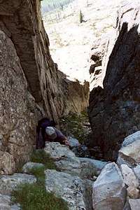
The couloir to
the summit of
Totem Peak.
Tim Sharp Photo.
While building the following list I tried to include only those summits (peaks) which, if close to another prominence, are at least 300’ above the saddle which connect the two.
A substantial amount of time has been spent poring over Topo maps (both paper and computer) during the compilation of this list; however that doesn't mean the list is perfect. If you find errors or omissions, please let me know so I can make corrections.
There are a lot of unnamed peaks in the Bitterroot Mountains, many of them on this list. Some of those "unnamed" peaks, along with the names some have "unofficially" applied to a few of them, appear below. Each of the unnamed peaks is listed either as: Unofficial Name (point nnnn) or Short Description of Location (point nnnn).
The Latitude and Longitude are also listed for each summit to help anyone unfamiliar with the area discover its location.
You will notice that most of these summits have not yet been posted (climbed) by even one Summitpost member. Hopefully that will soon change.
| Name | Elevation | Latitude | Longitude |
|---|---|---|---|
| 8,900' to 8,999' | |||
| Gem Lake Peak (point 8,992) | 8,992' | 45.89583 N | 114.27277 W |
| Castle Crag | 8,984' | 46.33072 N | 114.37165 W |
| West Camas Peak (point 8934) | 8,934' | 46.16494 N | 114.32558 W |
| Canyon Lake - West (point 8922) | 8,922' | 45.85923 N | 114.44761 W |
| Camas Point | 8,874' | 46.17359 N | 114.21604 W |
| Middle Camas Peak (point 8905) | 8,905' | 46.16327 N | 114.31674 W |
| 8,800' to 8,899' | |||
| Gash Point | 8,886' | 46.43347 N | 114.31955 W |
| Pyramid Buttes | 8,869' | 46.62829 N | 114.25799 W |
| Disappointment Peak (point 8865) | 8,865' | 46.51202 N | 114.28564 W |
| Bass Peak | 8,855' | 46.57783 N | 114.31749 W |
| Bear Lake - North (point 8839) | 8,839' | 46.44679 N | 114.34578 W |
| Boulder Lake - NW (point 8832) | 8,832' | 45.86691 N | 114.40383 W |
| Piquett Mountain | 8,831' | 45.73194 N | 114.19013 W |
| Sugar Point (point 8820) | 8,820' | 45.94295 N | 114.28406 W |
| Ranger Peak | 8,817' | 46.50236 N | 114.39909 W |
| Hauf Peak (point 8807) | 8,807' | 46.29387 N | 114.31351 W |
| 8,700' to 8,799' | |||
| Vance Mountain (Idaho) | 8,793' | 45.91215 N | 114.49207 W |
| Sky Pilot | 8,792' | 46.43690 N | 114.36750 W |
| Soda Springs Peak - West (point 8787) | 8,787' | 45.83119 N | 114.42847 W |
| Triple Creek Peak - Idaho (point 8785) | 8,785' | 45.96729 N | 114.40275 W |
| Watchtower Peak | 8,780' | 45.82983 N | 114.51052 W |
| Lake Lomo - West (point 8774) | 8,774' | 46.24607 N | 114.39239 W |
| East Camas Peak (point 8766) | 8,766' | 46.45366 N | 114.29864 W |
| Soda Springs Peak - East (point 8740) | 8,740' | 45.82561 N | 114.41103 W |
| Lookout Lake - East (point 8740) | 8,740' | 46.06995 N | 114.44155 W |
| High Lake Peak - South (point 8717) | 8,717' | 46.24016 N | 114.36673W |
| Little Rock Creek Lake - West (point 8712) | 8,712' | 46.02360 N | 114.36989 W |
| Stormy Pass - NE (point 8702) | 8,702' | 46.51038 N | 114.34738 W |
| 8,600' to 8,699' | |||
| Downing Mountain | 8,690' | 46.23330 N | 114.29975 W |
| Bass Peak - West (point 8687) | 8,687' | 46.57573 N | 114.32880 W |
| Romney Ridge Highpoint | 8,685' | 46.25508 N | 114.32745 W |
| Printz Ridge - West (point 8663) | 8,663' | 46.29163 N | 114.38330 W |
| West Sheafman Peak (point 8652) | 8,652' | 46.33758 N | 114.33979 W |
| Mill Point West (point 8650) | 8,650' | 46.29173 N | 114.29375 W |
| East Sheafman Peak (point 8650) | 8,650' | 46.33782 N | 114.32460 W |
| Blodgett Mountain | 8,647' | 46.27328 N | 114.46398 W |
| Shephard Peak (point 8641) | 8,641' | 45.80452 N | 114.51184 W |
| Capitan Creek - South (point 8636) | 8,636' | 45.97809 N | 114.41104 W |
| Two Lakes - West (point 8628) | 8,628' | 46.40323 N | 114.39889 W |
| Stingray Lake - East - Idaho (point 8624) | 8,624' | 45.98322 N | 114.53129 W |
| Hidden Lake Peak (point 8618) | 8,618' | 46.46116 N | 114.32088 W |
| Glen Lake - NW (point 8608) | 8,608' | 46.46061 N | 114.29978 W |
| El Capitan - South (point 8605) | 8,605' | 45.99033 N | 114.39588 W |
| One Horse Peak (point 8605) | 8,605' | 46.67059 N | 114.18969 W |
| Big Grizzly Peak (point 8601) | 8,601' | 46.03054 N | 114.47943 W |
| 8,500' to 8,599' | |||
| Sears Lake - SE (point 8587) | 8,587' | 46.29360 N | 114.36229 W |
| Wyant Peak (point 8578) | 8,578' | 46.23973 N | 114.33630 W |
| Downing Mountain - West (point 8573) | 8,573' | 46.23695 N | 114.32229 W |
| Tin Cup Pass - NE (point 8570) | 8,570' | 45.95334 N | 114.40849 W |
| Big Creek Lake Peak - W (point 8570) | 8,570' | 46.48852 N | 114.39991 W |
| Tin Cup Pass - South (point 8546) | 8,546' | 45.95334 N | 114.40849 W |
| Big Creek Lake Peak - W (point 8570) | 8,570' | 46.48852 N | 114.39991 W |
| Tin Cup Pass - South (point 8546) | 8,546' | 45.93324 N | 114.42729 W |
| Stingray Lake - NE - Idaho (point 8536) | 8,536' | 45.99672 N | 114.52018 W |
| South Kootenai Lake - S (point 8535) | 8,535' | 46.52213 N | 114.32731 W |
| Bass Lake - South (point 8533) | 8,533' | 46.58079 N | 114.28274 W |
| North Lost Horse Peak (point 8528) | 8,528' | 46.16699 N | 114.39969 W |
| Lappi Peak (point 8524) | 8,524' | 46.57027 N | 114.25305 W |
| Brushy Fork Lake - SE - Idaho (point 8524) | 8,524' | 45.97627 N | 114.58417 W |
| Lake Capitan - South | 8,523' | 45.99222 N | 114.47526 W |
| Totem Peak | 8,521' | 46.37379 N | 114.39226 W |
| Como Point - Point 8517 | 8,517' | 46.00786 N | 114.31669 W |
| Goat Mountain Highpoint (point 8505) | 8,505' | 46.21400 N | 114.41974 W |
| Nipple Knobb - Idaho | 8,505' | 45.99481 N | 114.56833 W |