|
|
Mountain/Rock |
|---|---|
|
|
42.11890°N / 119.0016°W |
|
|
Harney |
|
|
Hiking |
|
|
Spring, Fall, Winter |
|
|
6903 ft / 2104 m |
|
|
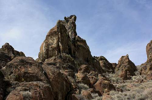
Lone Mountain
Lone Mountain is one of three peaks standing above Hawks Valley near the Nevada border in Southeast Oregon. Laying between the Guano Rim and Pueblo Mountains, Hawks Valley is a depression receiving scant rainfall and is a true sagebrush desert devoid of trees or water. Very little makes this area of interest, the highest point in the basin is Hawks Mountain which climbs a little over 7000 feet, and Acty Mountain is an east facing fault scarp cutting across the minor east-west uplift that forms Hawks Mountain. What makes Lone Mountain of interest is the 3+ square miles of Palisades along its lower southern slopes. Contrasting sharply against the rolling sagebrush hills, along Lone Mountain is row upon row of pinnacles cutting into the sky. Pinnacles highlighted by juniper groves huddled around hidden springs amongst the vast fields of broken rock. The Palisades are what sets Lone Mountain apart here in the shadow of the Pueblos, and the mountain is a true treasure of the Oregon High Desert.This is a wilderness study area, and a number of springs marked by the government back in the 70's can be found hidden in the rocks. Granite Springs below was the most prominent, producing the most water and with the most scenic backdrop. Here 30 miles from the nearest rivers, frogs were abundant and provided some background noise in the evening once the Red Tailed Hawks and Western Meadowlarks had quieted down.
 Granite Spring
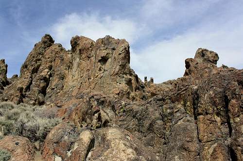
A few small natural arches can be found in the labyrinth of rocks, along with caves, slot canyons, and an old stone corral. It would take a lot of time to explore everything here, and canyons often lead to dead ends or cliffs. Some of the pinnacles were fairly tall, with some reaching 50 to 70 feet. There is plenty of scrambling and slab climbing to be done here, just a fun maze of rocks to explore.
According to the topo Lone Mountain is actually a series of highpoints over the course of several miles. The map marks a summit of 6903 feet at the lat. and long. listed above. Once you've reached this point you may notice that the point half a mile to the east appears higher. I crossed a saddle and checked the elevation by GPS which found this unmarked spot about 15 feet higher. GPS can be unreliable, but this appeared to be the true summit. Lone Mountain has 1320 feet of prominence and is the 3rd highest point ringing Hawks Valley behind 7234 foot Hawks Mountain and 7019 foot Acty Mountain.
 A small arch
Getting There
Like many of the lesser known mountains of Southeast Oregon, this one is many miles of 4x4 road from the nearest highway. For Lone Mountain, it is accessed from highway 205 at the southern end of the Catlow Valley. Where 205 turns east to climb over the southern pass between Steens Mountain and the Pueblo Mountains a dirt single lane 4x4 road continues south along the Catlow Rim. Marked with a sign pointing towards Funnel Canyon, Basque Hills, and Hawks Valley, this will lead you 20 miles generally south up Funnel Canyon to Hawks Valley and the trio of peaks ringing it.Hawks Valley is much smaller than the nearby Catlow Valley, and is completely featureless other than signs of a 1970's federally subsidized irrigation project that can be seen along the road in spots. Once Funnel Canyon opens into Hawks Valley you will see Acty Mountain ahead to the SW, Hawks Mountain to the south, and Lone Mountain rises to the southeast. Following the road directly south across Hawks Valley leads to a T where a turn to the east and 3.4 miles of travel will bring you to the southern face of Lone Mountain. Find a 4x4 road heading towards the peak, drive up it and find a place to begin your hike.
Whitts Cache Spring is a fun place to start, from here expect 1200 feet of elevation gain with some class 3 mixed in. Total distance will be between 1.5 and 2 miles one way entirely dependant on how you pick your path through the palisades.
Additionally Barbara Bond describes route and directions in her book 75 Scrambles In Oregon.
Red Tape - Camping
This is wide open BLM land for miles and miles and miles. You probably wont be out here in the summer so go ahead and build a campfire. The best camping will be at the springs along Lone Mountain's southern Palisades, try to avoid cutting and burning anything other than sagebrush as trees are in short supply around here. You may run into ranchers or cattle, but neither should be any kind of nuisance providing you aren't here in the summertime when cattle maybe swarming the springs and the rare water they provide in the Hawks Valley Region. Predators such as cougar and coyote may be drawn to the springs, but both are very elusive when people are about.Like any other area of Southeast Oregon, its highly advised you bring at least one spare tire, and are driving a 4x4 with robust tread. The road up Funnel Canyon has been recently graded, and is in decent shape, but sections are still pretty rough, and sand reaches depths greater than 6 inches deep in places. In late winter mudholes may occupy parts of the road, but should be easy to circumnavigate.
 Many Caves Here
 Area Map
Weather

 Near Juniper Spring