
-
 18070 Hits
-
 84.27% Score
-
 18 Votes
|
|
Mountain/Rock |
|---|---|
|
|
42.73360°N / 118.5433°W |
|
|
Harney |
|
|
Hiking |
|
|
Summer, Fall |
|
|
9348 ft / 2849 m |
|
|
Overview
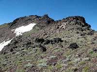

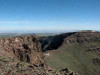
The Steens Mountains are a 30 mile fault scarp that runs north and south. The eastern side drops dramatically to a valley floor and the Alvord Desert (the driest area in Oregon) and about 5,800 ft below the highpoint on the ridge. The Steens are volcanic in origin and the multiple layers of volcanic deposits can be clearly seen in the canyons, gorges, and on the eastern escarpment. In the year 2000 the entire Steens area comprising 900,000 acres were set aside to be managed by the BLM as the Steens Mountain Cooperative Management and Protection Area.
The Steens are home to a variety of wildlife including bighorn sheep, mule deer, elk, and antelope. Wild horses called Kigers that are descendants of the horses brought over by the Spanish Conquistadors. The Steens Mountains have a rich history in the development of the west and this area of Oregon. Because of their height and prominence, the Steens are visible from over a hundred miles away in all directions. The Steens are the 7th most prominent peak in Oregon
Getting There

Near the historic hotel in Frenchglen is the turnoff that goes to the Steens Mountain area. The turn-off is well marked. Head up this wide gravel road known as the Steens Mountain National Back Country Byway. It is about 20 miles to the “trailhead”. There is no formal trail, so continue up the road until you see the turnoff for the Kiger Gorge Overlook. You can go to the parking area at the end of the Overlook road, or continue up the main road for another .4 mile and just park as much off the road as you can. Either way you should go to the Overlook first to see where you will be climbing. As you look down into the Kiger Gorge, notice the eastern edge of the gorge and the big U notch about half way down the ridge. The highpoint you want is just before the U notch. The easiest route to the highpoint is to follow the ridge from the south.
Red Tape
BLM Burns District
Fishing Info
BLM Steens Information
Camping

BLM Camping Areas
Steens Mountain Resort
Harney County Info
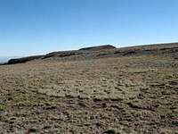
You could make a bivy site at the summit if you wish since the summit area is relatively flat. It is rocky and could be windy and cold.
When to Climb
Winter snow closes the road, call the BLM in Burns for road conditions. This year (2007) the road opened in mid-June.
Mountain Conditions
This mountain is accessible until the first good snow storm of the winter covers the road. The road is not plowed and you have to wait for the springtime melt to get up the road.For current weather conditions in the area follow these links:
Fields, Oregon
Burns, Oregon