
|
|
Route |
|---|---|
|
|
40.76260°N / 110.58301°W |
|
|
Hiking |
|
|
Summer |
|
|
A long day |
|
|
Class 3 |
|
|
 Mount Lovenia
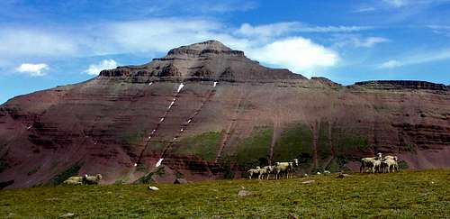 East Lovenia
Overview
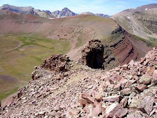
This page describes a route to two seldom visited Utah 13000 footers, East Lovenia (13032') and Mount Lovenia (13219'). They are located in the heart of the High Uintas Wilderness. Ringed near the summit by cliffs, East Lovenia is the hardest to climb of all the Utah 13000 footers. The route is never more than class 3, but requires a .5 mile traverse across a steep slope with cliffs below which is not for the faint hearted. East Lovenia section of route
Stats
 Mount Lovenia
Total mileage: 23.82
Trail mileage: 16.42
Off-trail mileage: 7.4
Total elevation gain: 5050'
Lowest elevation: 9300'
Highest elevation: 13219'
Getting There
 The High Uintas skyline from I80 in Wyoming
Take I80 to exit 34 in Wyoming and head to Fort Bridger. Go 5.3 miles to a blinking red light. Turn right on Wyoming state route 414 and go 3 miles to Wyoming state route 410. Follow 410 for 13 miles. First you will see a sign that says the pavement ends in 750 feet. Shortly you will see another sign for "Blacks Fork River Access Area" and then another one that says "Wasatch Nat'l Forest/Meeks Cabin 13". If you miss the signs, don't worry, the three sets of rumble strips should wake you up. Do as the signs say and turn left. The road you turn onto starts out paved but soon changes to dirt. Follow the main road 23.6 miles to the signboard (just past a gate) for the East Fork Blacks Fork Trail. The trail start is just before the signboard. There is no parking right at the trail start. Instead, continue on the road for just a few feet and turn right and then left into the parking lot.
Route Description
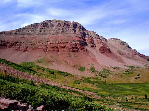
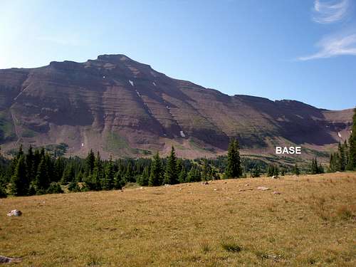
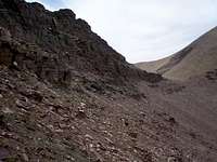
Follow the East Fork Blacks Fork trail for 8.2 miles to the point labeled LEAVETRAIL on the map. The trail is primarily easy walking and easy to follow, but passes through several marshy areas in which the tread disappears. Just go straight and you will pick it up again. Some waypoints are provided on the map to keep you on the right track. There are several unbridged stream crossings, but most of them have logs across. There is one crossing that requires fording the stream, but late in the summer it is only ankle deep. However, I noticed a good log (marked on map) .4 miles upstream that I will try next time. It doesn't go all the way across so I don't think it will work early in the summer, but in the middle of August, there were some bare rocks at both ends.Leave the trail and head cross country to the point labeled BASE on the map and picture. It is easy walking as it starts out through widely spaced trees and soon changes to open tundra crossed by a few small streams.
 You are heading to BASE
Once you reach the base of East Lovenia, simply head for the saddle to the peak's west. From a distance, it looks intimidatingly steep, but there are no tricky parts, it is just a steep slope. At its steepest, you will climb 1000' in .3 miles. The first half is a delight as it is primarily vegetated with just a few rocks and is very stable and it is easy to make upwards progress. The next quarter of the slope is mostly stable boulders. It is only the last quarter that is a somewhat painful mixture of loose dirt with some medium sized sliding rocks sitting on top. Upwards progress in this section is slow. Downwards would be much easier, kind of like walking downhill on snow. I saw domestic sheep quite high up and walked in their footprints as I approached the saddle.
 The break in the major cliff band The break in the major cliff bandFrom the saddle, head east along East Lovenia's west ridge to the summit. I stayed almost always on the north side of the ridge crest and only occasionally was on top. I never set foot on the south side of the ridge. There are a couple of minor cliffy sections that are easy to skirt at the start and then one major one. Just stay at the base of the cliff and make your way up at the first break you see. After climbing about 10-15 feet up it opens out and the remainder of the climb is just a straightforward boulder hop. |
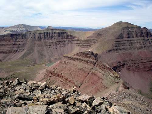
From the summit you will have great views in all directions, but to the east on the horizon, you can make out 13 of Utah's 19 13000 footers.
 View to the east
Make your way back down the way you went up until you rereach the saddle. Here you have a choice. Looking ahead you will see a long cliff in front of you.
 Starting the descent, note the long, skinny cliff below Starting the descent, note the long, skinny cliff below | 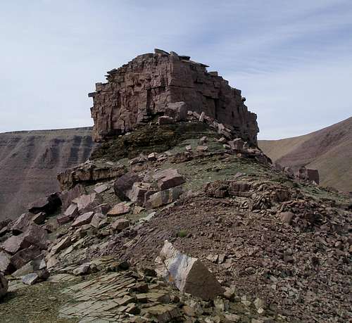 The cliff up close The cliff up close |
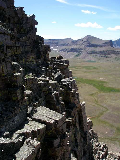
 Getting close to the west saddle Getting close to the west saddle Looking back towards E Lovenia Looking back towards E LoveniaI stayed to the north of this cliff all of the way to the broad saddle just east of Mount Lovenia. In MOCKBA's East Lovenia page he remarks how he did this section by climbing up on top of the cliffs and says this is low class 5 at both ends. Traversing below them is class 3 at most and is primarily class 2. However, it is not without peril. One slip could have disastrous consequences. At its steepest, you will be traversing a 45 degree slope with cliffs below. If you loose your footing and start rolling, you might not be able to stop. It starts out primarily as loose dirt and shale at the east end and gradually transitions to mostly boulders at the west end. This kind of stuff is murder to ascend, but easy to cut across or descend. In pictures, from far away, it looks impossibly steep, but up close it doesn't look so bad. |
Caution: unless you are used to these kinds of slopes, you probably won't like either the section leading up to the saddle or the traverse beneath the cliffs.
From the saddle east of Mount Lovenia it is only a straightforward class 2 boulder hop to the top of the peak. It doesn't look that high up, but in reality you have 1000' to climb.
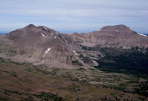
From the summit there is an outstanding view of the seldom climbed and very remote Cleveland/Squaw/Explorer ridge.
 Cleveland, Squaw, Explorer, and N Explorer Peaks
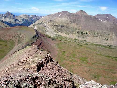 Starting the descent Starting the descentFrom the summit of Mount Lovenia descend via the class 3 northwest ridge. |
 The ridge crest The ridge crestThis ridge is very rugged in places and has lots of unstable looking outcrops. |
 The big tower The big towerThey can all be avoided if you choose by staying southwest of the ridge crest. But, shortly before the obvious big tower is reached |
 Ledge on the left Ledge on the leftif you want to do a little scrambling, there is an exposed ledge |
 The other side is narrower and more exposed The other side is narrower and more exposedthat continues around to the other side. |
 Looking southwest Looking southwestBut, if you don't feel comfortable with that, you can simply descend to the southwest under these outcrops and skirt it all. |
After descending 1,350 feet you will reach a saddle. From this point on, the route is class 1. Continue on the ridge northwest from the saddle and ascend another 300 feet where you will find the trail. Directly ahead of you to the north is Wasatch Benchmark (13156').
 The trail is just past the snow patch The trail is just past the snow patch |  Wasatch Benchmark Wasatch Benchmark |
The trail reaches another saddle in a few feet and then descends east via switchbacks to the upper reaches of East Fork Blacks Fork. I found numerous sheep in this area. The trail is obvious at first but soon the tread is lost to tundra and your way is well marked with cairns. In a mile or so the tread again becomes obvious and you simply follow the trail back to the trailhead a total of 10.5 miles from where you picked it up.
 Heading back to the trailhead, the Blacks Fork ridge lies ahead
Essential Gear
Either a GPSr or a compass is useful for getting to the base of E Lovenia. If you don't want your boots to get wet an old pair of sneakers will come in handy.Camping
There is a nice campground just past the parking lot. It has about 10 sites. It is free but there is no water.If you elect to do this hike as a backpack vs a day trip, you shouldn't have any problem finding a suitable place to camp along the trail.
Time needed
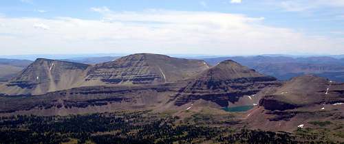
 Wasatch Benchmark, NW Wasatch, and Tokewanna Peak
This route can be done in one long day. It took me about 14 hours round trip, 6 to get to East Lovenia, another 2 to get to Lovenia, and another 6 back to the trailhead. Most people would prefer to set up a base camp. If chosen wisely, one could also conveniently reach Wasatch Benchmark, NW Wasatch, and Tokewanna, three other nearby Utah 13000 footers, on the same trip.
When to Climb
 Late July
As summer progresses, the stream crossings will get easier and easier. August and the beginning of September would be the best times. Any later than that, you will most likely encounter snow on the northern facing slopes.
Map
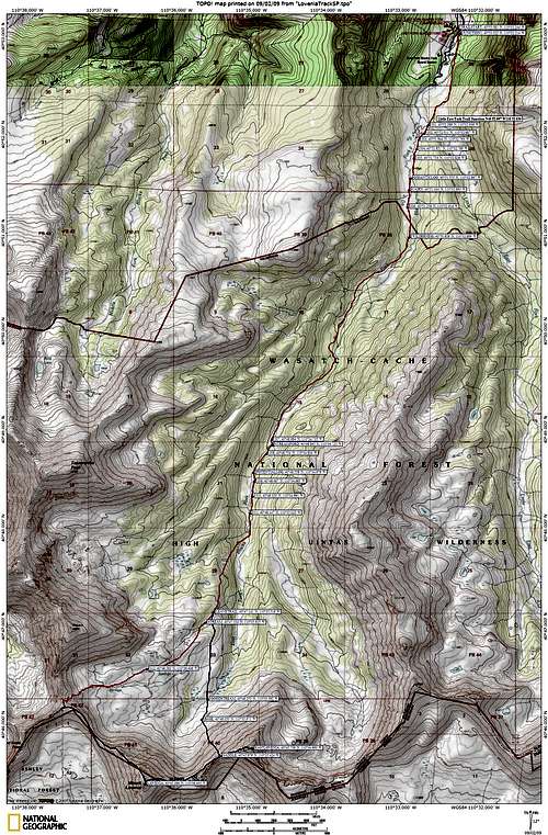
Note that the red line accurately shows the trail on the map. The blue line is the off trail portion. Waypoints are provided for where to pick the trail up at the end of a meadow