
|
|
Mountain/Rock |
|---|---|
|
|
40.75690°N / 110.6074°W |
|
|
13219 ft / 4029 m |
|
|
Overview
Mount Lovenia is a spectacular and seldom visited summit. Because of tedious scree, it is one of the more difficult of the 13’ers in Utah (there are 17-21 of them, depending on the list), but is still quite a bit easier than its neighbor to the east (East Lovenia). This is one peak where you can usually have solitude, but ever so slowly, bagging the 13’ers of Utah is becoming more popular.The Uinta Mountains are one of the few mountain ranges in North America that run east to west rather than north to south. Within the Uinta Mountains are about 2000 lakes, and some 900-1000 are full of trout. Along with the San Juans in Colorado, the Uintas have more contiguous area above timberline than any other area in the Continental United States. This is a beautiful area with many lakes, meadows, wildflowers, and some rugged peaks. Solitude is usually easy to come by once you leave the popular fishing holes behind.
One thing that makes Utah's 13'ers different, then say the Colorado 14'ers, is that the distances from the nearest roads are usually much greater for the Utah 13'ers.
Utah's 12,000+ Foot Peaks With 200+ Feet Prominence
Utah's 12,000+ Foot Peaks With 300+ Feet Prominence
Note: Since my photos are poor, this page will be a joint effort of a few SP members whom have added and will add their high-quality photos. I thank them for this.
 Lovenia as viewed from the east of Wasatch.
Getting There
EAST FORK BLACKS FORK TRAILHEADFrom The West
From the traffic light in Kamas and the intersection of route 248 and 32, head north 0.1 to SR 150 (Mirror Lake Highway). Turn right onto SR 150 and follow for 49 miles to FR 058, turn right onto FR 058 (gravel road) and follow for 21.2 miles to the intersection with another dirt road heading north south. Turn right and follow road south for approximately 6 miles to the parking area at the East Fork Blacks Fork Camping area and trailhead.
*SP member Grandwazoo provided some of the details on the drive.
From The North
Exit I-80 at exit 30 and head south on CR 207 for 7.9 miles to a “T”. Turn left onto CR 204 and follow southeast for 2.4 miles to another intersection. Turn right onto CR 271 and follow southerly for 15.2 miles to the Utah – Wyoming state line. Continue south following same road (FR073) for 2.7 miles to an intersection with FR058. Stay left or straight, continue on FR 058 for 0.7 miles to an intersection with FR 065. Stay Left here, 058 bears right at this intersection. Continue South on FR 065 for approximately 6 miles to the trailhead and campground.
WEST FORK BLACKS FORK TRAILHEAD
From the traffic light in Kamas and the intersection of Route 248 and 32, head north 0.1 to SR 150 (Mirror Lake Highway). Turn Right onto SR 150 and follow for 49 miles to FR 058 aka "North Slope Road", turn right onto FR 058 (gravel road) and follow for 16 miles to the 4-way intersection with the West Fork Blacks Fork Road turning south. Turn right and follow the rough dirt road to where it crosses the river. It is highly recommended you park here, no matter what type of vehicle you own. The river crossing is very rough and driving through the meadows along the heavily rutted 4wd road is at best, environmentally insensitive, not to mention damaging to your vehicle.
 The northeast face of Mt Lovenia.
Routes Overview
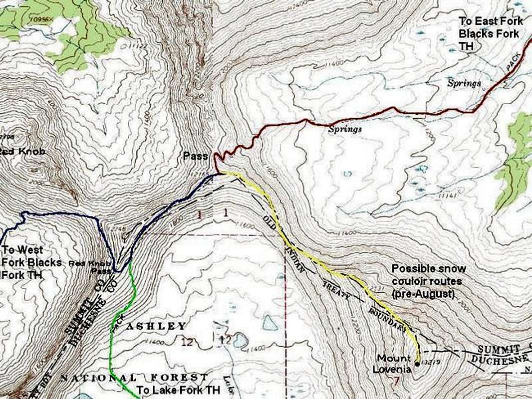
East Fork Blacks ForkThis is the easiest route on Mount Lovenia. The route accesses East Red Knob Pass from East Fork Blacks Fork and then follows the Class 3 Northwest Ridge of Mount Lovenia to the summit. The route is about 27 miles round from the East Fork Blacks Fork Trailhead, and usually takes three days, though strong climbers can do the route trip in two long days.
 The East Fork Blacks Fork Trail winds it way up past 11,300 feet on its way to Red Knob Pass.
West Fork Blacks Fork
This is the second easiest route up Mount Lovenia, and the most scenic. The West Fork route is longer, however, and the access road is much rougher. The West Fork Blacks Fork is one of the more scenic drainages in all of the Rocky Mountains, and contains some of the most rugged peaks in the state of Utah. Like the route from East Fork Blacks Fork, the route accesses East Red Knob Pass and then follows the Class 3 Northwest Ridge of Mount Lovenia to the summit. This route is about 31 miles round trip from the East Fork Blacks Fork Trailhead and usually takes three days.
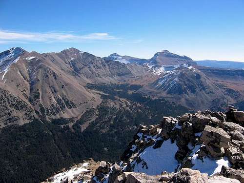 Looking accross West Forks Blacks Fork from Mt. Beulah. Mount Lovenia is the peak on the right.
Lake Fork Route
This is another long route (44-50 miles) from the south starting at Moon Lake. The trail is in good condition to Red Knob Pass, but this route will not be discussed on the page because the northern routes above are more scenic and shorter. If you don’t mind hiking many miles below timberline without many views, it would make a viable route.
 Just before dropping into Lake Fork, the trail passes the southern tip of the Mt. Lovenia ridge.
 Final Ascent Route to the Summit
As mentioned, the standard route for the final ascent is via the Northwest Ridge. An old guidebook marked a possible route via the South Ridge on a map, but it is cliffed-out, and the rock isn’t good for tech climbing. The Northeast Face of the peak looks like it has some really nice snow couloir routes, but I haven’t tried them. The East Ridge can be used, especially if you want to climb “East Lovenia” on the same trip, but this is a very slow and rough route.
Red Tape
No permits are required. Normal wilderness restrictions apply.When To Climb
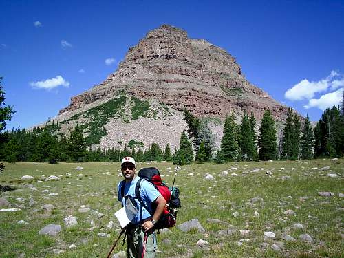
July through September is the normal climbing season. Since access roads are not open in the winter, winter ascents are almost never done and would take most climbers at least a week and a half. At last report (2005) there were no known winter ascents of the peak.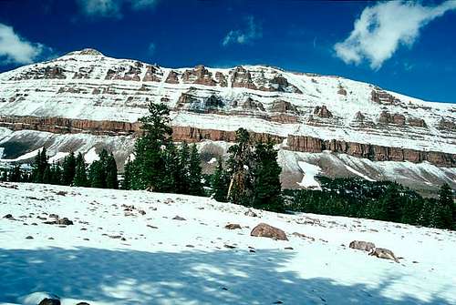 Mt Lovenia in mid-June.
Camping
East Fork Blacks ForkThere is a rustic campground near the trailhead that is located in a grove of lodgepole pine and aspen. There is no charge for camping.
West Fork Blacks Fork
There are many unofficial campgrounds on the road to the trailhead.
Backcountry campsites are many on either of the main trails to the Mount Lovenia area.
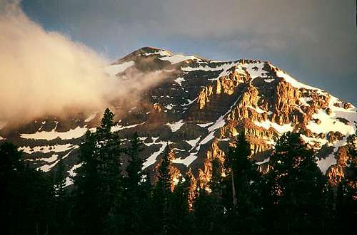
 Mt Lovenia looks to be on fire during this vivid sunset.
Mountain Conditions
Information regarding the conditions of the forest roads to the trailhead - Wasatch-Cache National Forest, Evanston Ranger District, 1565 Highway 150, Box 1880, Evanston, WY 82931; (307) 789-3194.Click here for forest service information.
Information regarding the conditions for climbing these peaks can be obtained from Wasatch-Cache National Forest, 8236 Federal Bldg., 125 S. State Street, Salt Lake City, UT 84128, (801)524-3900.
The National Weather Service has a new weather link for the Central Uinta Mountains.
Weather Forecast for Central Uinta Mountains
Here are some average highs and lows from the 13,123 foot elevation (4000 meters) in the Uintas (about the same altitude as the summit):
| MONTH | HIGH | LOW |
| JAN | 11 | -4 |
| FEB | 13 | -2 |
| MAR | 16 | 1 |
| APR | 24 | 8 |
| MAY | 32 | 15 |
| JUN | 42 | 22 |
| JUL | 52 | 29 |
| AUG | 50 | 28 |
| SEP | 42 | 21 |
| OCT | 31 | 12 |
| NOV | 19 | 5 |
| DEC | 14 | 0 |