
-
 6155 Hits
-
 79.04% Score
-
 10 Votes
|
|
Area/Range |
|---|---|
|
|
46.56802°N / 10.91547°E |
|
|
Hiking, Mountaineering, Ice Climbing, Mixed, Scrambling, Skiing |
|
|
Spring, Summer, Fall, Winter |
|
|
11283 ft / 3439 m |
|
|
1 - Overview
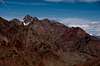
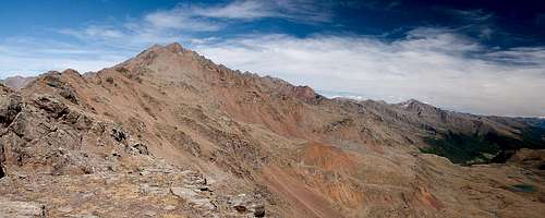 Looking along Marteller Hauptkamm from its south-western end Looking along Marteller Hauptkamm from its south-western end |
The largest subgroup of the large Ortler / Ortles Group is located at its north-western end. It is a single ridge, which stretches from the central part of the range, i.e. from the vicinity of Monte Cevedale, all the way to the north-west, where it ends right above the city of Meran / Merano. It is wedged between Ultental / Val d'Ultimo in the south, lower Vinschgau / Val Venosta in the north and Martelltal / Val di Martello in the west. From this latter valley, or rather the village at the mouth of it the subgroup derives its name: Marteller Hauptkamm. Literally translated, this would be Cresta Principale di Martello in Italian or Martell Main Ridge in English.
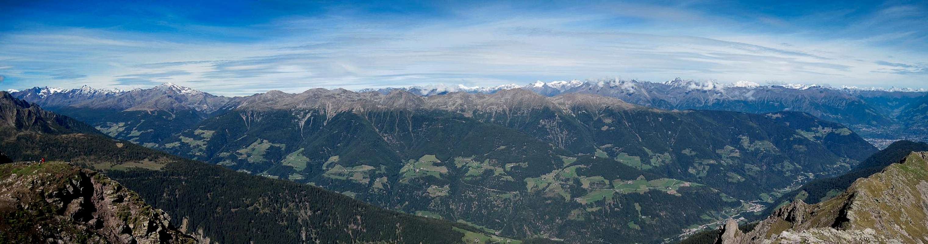
The crest stretches some 25km from WSW to ENE with the highest mountains, all 3000ers, at one end from where elevations gradually drop until they reach some 1600m before finally dropping into the Etsch / Adige basin above Meran / Merano. Consequently the different parts of the range are very different and activities also vary a lot. While in the higher parts there are only few hiking trails and most mountains are reserved for alpinists the western parts of the ridge are wonderful hiking grounds with a huge network of trails. In winter, however, all parts of the subgroup attract tour skiers and there is many a mountain which gets ascents in the wintertime.
 |  |  |
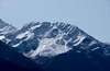
Geologically, Marteller Hauptkamm stands a little aside from the rest of the Ortler / Ortles Group. It consists of eruptive rocks - reddish gneiss in the south-west, grey granite in the north-east. All across the ridge however, rock quality is rather poor, with big scree fields covering the lower parts of the summit areas. Glaciers can only be found in the higher south-west, with the huge Vedretta di Careser being the southern boundary of the subgroup.
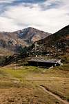
 Martelltal
The highest mountain of Marteller Hauptkamm is Zufrittspitze / Gioveretto, which stands right between the ends of Ultental / Val d'Ultimo and Martelltal / Val di Martello though not at the south-western end of the crest. It is one of two mountains which can be reached by a ferrata-like protected section, the other being neighbouring Hintere Eggenspitze / Cima Sternai. The central mountain of the group is Hasenöhrl / L'Orecchia di Lepre, the easternmost 3000er, which attracts attention from all sides. It is also the last mountain to cary (two) glaciers, which however appear to be in steady decline. Here also, east of Hasenöhrl the Nationalpark Stilfser Joch / Parco Nazionale dello Stelvio, which covers the central Ortler / Ortles Group ends, leaving the eastern part of the group rather unprotected. It is in this eastern part where you find ski runs, cable-cars, water reservoirs, however still in a moderate amount.
The whole crest of Marteller Hauptkamm / Cresta Principale di Martello offers wonderful views, mainly into the Ortler / Ortles Group itself but also to the Ötztal Alps in the north and the Dolomites in the south west.
2 - Marteller Hauptkamm / Cresta Principale di Martello on SP
  |
- Marteller Hauptkamm / Cresta Principale di Martello
3 - The Summits
|
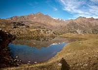
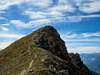
Marteller Hauptkamm is a single ridge, which runs WSW to ENE. There are several short ridges (mainly to the south), which, however, rarely consist of more than one summit. The highest mountains can be found in the south-west, close to the centre of the Ortler / Ortles Group. The summits are listed, starting from the south-west.
- Konzenspitze / Punta la Cuna (2830m)
- Köllkuppe / Cima Marmotta (3330m)
- Cime Venezia / Veneziaspitzen (I: 3386m, II:3371m, III: 3356m)
![]()
- Vordere Schranspitze / Cima Serana (2888m)
- Hintere Schranspitze / Punta Martello (3357m)
- Vordere Rotspitze / Cima Rossa di Martello (3033m)
- Hintere Rotspitze / Cima Rossa di Saent (3347m)
![]()
- Innere Gramsenspitze / Cima Grames di Dentro (3159m)
- Äußere Gramsenspitze / Cima Grames di Fuori (2914m)
- Sällentspitze / Cima di Saent (3215m)
- Hintere Nonnenspitze / Cime di Rabbi (3256m, 3269m)
- Vordere Nonnenspitze (2782m)
- Lorchenspitze / Cima Lorchen (3347m)
- Hintere Eggenspitze / Cima Sternai (3443m)
![]()
- Vordere Eggenspitze / Cima Sternai Meridionale (3385m)
![]()
- Weißbrunnerspitze / Cima Fontana Bianca (3253m)
![]()
- Zufrittspitze / Gioveretto (3439m)
![]()
- Altplittschneid / Cresta Alta (3232m)
![]()
- Zehnerspitze / Cima Dieci (2804m)
- Zwölferspitze / Cima Dodici (2680m)
- Ebenes Jöchl (2786m)
- St. Johann Spitze (2657m)
- Soyspitze (3030m)
- Flimspitze (3113m)
![]()
- Tuferspitze / Cima di Tovo (3097m)
- Hasenöhrl / L’Orecchia di Lepre (3257m)
![]()
- Grabensprungspitze / Cima Fosso di Salto (3014m)
![]()
- Murmentenblais / Monte Murmenta (2627m)
- Hohe Marchegg / Monte Confinale (2551m)
- Hoher Dieb / Gran Ladro (2730m)
![]()
- Mutegrubspitze / Fossa di Muta (2736m)
- Rontscher Berg / Monte dei Romici (2711m)
![]()
- Peilstein / Il Sasso (2542m)
- Moarkuck (2616m)
- Viehhirtenspitze (2540m)
- Naturnser Hochwart / Guardia Alta di Naturno (2608m)
![]()
- Staffelsberg / Monte Scaglioni (2443m)
![]()
- Naturnser Hochjoch (2440m)
- Rauher Bühel / Colle Scarbro (2027m)
- Larchbühel / Dosso di Larici (1837m)


4 - Getting There
 |
Marteller Hauptkamm / Cresta Principale di Martello can be most easily reached fromthree Valleys: Ultental / Val d'Ultimo in the south, Vinschgau / Val Venosta in the north and Martelltal / Valle di Martello in the west. Only for the very southernmost summits, an ascent from Peio in the far south makes sense.
- Vinschgau / Val Venosta and Martelltal / Valle di Martello
- Take Brenner Motorway A22 to the exit Bozen Süd / Bolzano Sud
- Switch to SS38 towards Meran / Merano.
- Stay on SS38, which turns left (west) into Vinschgau / Val Venosta
- For Martelltal / Valle di Martello pass Latsch / Laces and at Goldrain / Coldrano turn onto SP2 south, which leads into the valley.
- Ultental / Val d'Ultimo
- Take Brenner Motorway A22 to the exit Bozen Süd / Bolzano Sud
- Switch to SS38 towards Meran / Merano.
- Take the exit Lana and drive through the town
- For the Ultental / Val d'Ultimo trailheads follow the signs into the valley
5 - Accommodation
6 - Red Tape
The south-western part (with all 3000ers) of Marteller Hauptkamm / Cresta Principale di Martello belongs to Nationalpark Stilfser Joch / Parco Nazionale dello Stelvio. See the following link for more information:7 - Weather Conditions
8 - Maps & Books
8.1 - Maps
- Ortler / Ortles - Cevedale
Kompass Map WK072
1:50000
ISBN: 3-85491-081-9
- Vinschgau / Val Venosta
Kompass Map WK52
1:50000
ISBN: 978-3-85491-058-9
- Meran / Merano
Kompass Map WK53
1:50000
ISBN: 978-3-85491-059-2
- VAL MARTELLO-SILANDRO-LACES
Tabacco Map 045
1:25000
ISBN: 978-8883150661
- VAL D´ULTIMO / ULTENTAL
Tabacco Map 042
1:25000
ISBN: 978-8883150562
- MERANO E DITORNI / MERAN UND UMGEBUNG
Tabacco Map 011
1:25000
ISBN: 978-8883150111
8.2 - Books
- Vinschgau
Rother Wanderführer
Rother Verlag
ISBN: 978-3-7633-4204-1
- Vinschgau / Ortlergruppe
Kompass Wanderbuch 950
Kompass Verlag
ISBN: 3-87051-404-3
- Ortleralpen
P. Holl
Alpenvereinsführer
Rother Verlag
ISBN: 3-7633-1313-3