
-
 7945 Hits
-
 83.1% Score
-
 16 Votes
|
|
Area/Range |
|---|---|
|
|
46.52718°N / 10.64941°E |
|
|
Hiking, Mountaineering, Trad Climbing, Mixed, Scrambling, Via Ferrata, Skiing |
|
|
Spring, Summer, Fall, Winter |
|
|
11631 ft / 3545 m |
|
|
1 - Overview
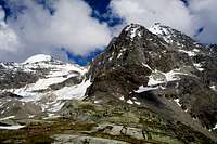
 Vertainspitze / Cima Vertana and Schildpitze / Punta di Scudo Vertainspitze / Cima Vertana and Schildpitze / Punta di Scudo |
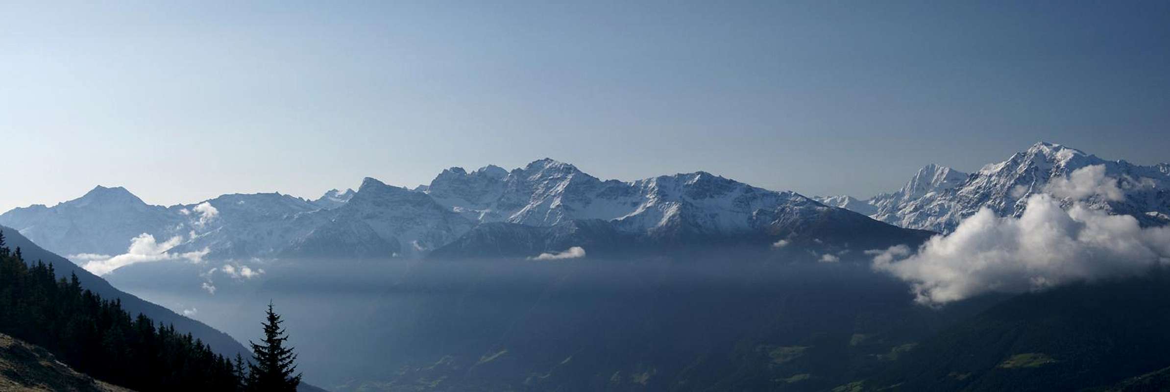
In the large Ortler / Ortles Group the most popular subgroups are located around the centre of the range. Apart from the Ortler / Ortles main ridge with the trinity Ortler / Ortles - Monte Zebru - Königspitze / Gran Zebru there are two more subgroups which attract special attention. Both are heavily glaciated and offer hiking, climbing and mountaineering possibilities of all kinds. They are the Cevedale - Vioz - San Matteo Group in the south and Laas - Marteller Kamm / Gruppo Vertana-Angelo-Lasa in the north-east.
As for the latter, the topic of this page, I'm afraid I have to give some explanation about the name. It follows the taxonomy of the German Alpine Club as given in their guidebook, which you will find in the Maps & Books Section at the end of the page. The Italian translation would be Cresta di Lasa e Martello which I'm afraid is never used. Rather than being composed of a single ridge, as the name would imply, the subgroup consists of three ridgelines, one of which separates into half a dozen minor ridges. The group's name stems from the village of Laas / Lasa in the north of the subgroup and Martelltal / Valle di Martello in its east. While both are good choices (see next paragraph) the naming rather ignores the biggest bulk of the group, the western ridges above Sulden / Solda which coincidentally contain the highest mountains of the whole group. Even in German literature the group is often referred to as Suldenkamm underlining the ambiguity of the name.
 |  |  |
Geographically Laas - Marteller Kamm / Gruppo Vertana-Angelo-Lasa is formed like a triangle (see the Google Map in the summits section) which is located right across Suldental / Val di Solda from the Ortler Main Ridge. Its boundaries are Suldental / Val di Solda in the west and Martelltal / Valle di Martello in the east, which both join at Eisseepass / Passo di Lago Gelato in the southern tip of the triangle. The northern boundary is Vinschgau / Val Venosta. From there, from the village of Laas / Lasa, a steep Valley cuts into the group: Laaser Tal / Valle di Lasa. It separates the northern part of the group in two - the eastern ridgeline of Marteller Westkamm / Cresta di Martello Occidentale and the half dozen ridgelines of Suldenkamm / Cresta di Solda in the west. Both groups join forces in the central mountain of the group, Schildspitze / Punta di Scudo, from which the main ridge runs towards Eisseepass / Passo di Lago Gelato.
 |  |  |
Most of the mountains of the group are either hiking summits or easy mountaineering destinations. In winter almost all of them are climbed as ski tours. In any case you will have to scale huge elevation differences as even the unimportant summits reach between 2700 and 2900m while the starting points in the valley can be as low as 850m (Laas / Lasa). The ends of both Suldental / Val di Solda and Martelltal / Valle di Martello are already above 1800m while the upper end of Laaser Tal / Val di Lasa reaches more than 2000m. Consequently you will find all the mountain huts of the group in these places. Most popular hiking summits are Vorderes Schöneck and Hinteres Schöneck as well as Hintere Schöntaufspitze, which can be reached from the Sulden ski area. Cable-cars facilitate the ascents.
 |  |  |
Most important summits are Großer Angelus / L'Angelo Grande and Vertainspitze / Cima Vertana, both over 3500m high. They form the western branch of the cirque of Laaser Ferner / Vedretta di Lasa, the largest glacier of the group, which at the same time forms the end of Laaser Tal / Val di Lasa. The eastern branch of the cirque is formed by Schildspitze / Punta di Scudo, Pederspitzen / Punte Peder and Lyfispitz / Punta Livi. On the northern outskirts of the group, two hiking mountains stand directly above Vinschgau / Val Venosta: Tschenglser Hochwand / Croda di Cengles and Orgelspitze / Punta di Lasa. Both are excellent lookouts though elevation differences can be huge.
2 - Laas - Marteller Kamm / Gruppo Vertana-Angelo-Lasa on SP
  |
- Laas - Marteller Kamm / Gruppo Vertana-Angelo-Lasa
3 - The Summits
|
- Eisseespitze / Punta di Lago Gelato (3230m)
![]()
- Butzenspitze / Cima Pozzo (3300m)
- Madritschspitze / Cima Madriccio (3265m)
![]()
- Mutspitze / Monte Muta (2912m)
- Hintere Schöntaufspitze / Punta Beltovo di Dentro (3325m)
![]()
- Vordere Schöntaufspitze / Punta Beltovo di Fuori (3214m)
- Innere Pederspitze / Punta Peder di Dentro (3309m)
![]()
- Plattenspitze / Punta delle Laste (3422m)
- Schildspitze / Punta di Scudo (3461m)
3.2 - Marteller Westkamm / Cresta Occidentale di Martello
- Mittlere Pederspitze / Punta Peder di Mezzo (3462m)
- Äußere Pederspitze / Punta Peder di Fuori (3406m)
- Sonnenwand / Croda del Sole (3203m)
- Kalfanwand / Croda della Calva (3061m)
- Pederköpfl / Dosso do Peder (2585m)
- Lyfihorn / Corno Livi (3370m)
![]()
- Lyfispitze / Punta Livi (3352m)
![]()
- Gemsspitze / Cima dei Camosci (3325m)
- Lyfiknott / Dosso di Livi (2851m)
- Lyfiberg / Monte Livi (2708m)
- Schluderzahn / Dente di Sluder (3253m)
- Schluderspitze / Punta di Sluder (3230m)
![]()
- Schluderhorn / Corno do Sluder (2809m)
- Rotwand / Croda Rossa (2962m)
- Laaser Spitze (Orgelspitze) / Punta di Lasa (3305m)
![]()
- Saugberg / Monte del Succhio (2759m)
- Weißwand / Croda Bianca (2778m)
- Jennwand / Croda di Jenne (2962m)
![]()
3.3 - Suldenkamm / Cresta Solda
- Vertainspitze / Cima Vertana (3545m)
![]()
- Hohe Angelusspitze / L’Angelo Grande (3521m)
![]()
- Hochofenwand / Croda Alta del Forno (3410m)
- Niedere Ofenwand dict/ Croda Bassa del Forno (2792m)
- Kleine Angelusspitze / L’Angelo Piccolo (3318m)
![]()
- Schafberg / Cima delle Peccore (3306m)
![]()
- Taitscheroi (Laaser Wand, Deutsche Ruhewand) / Cima Tedesca (3139m)
![]()
- Schafspitz / Monte delle Peccore (2754m)
- Saurüssel / Grugno del Porco (2727m)
- Gufeljoch / Giogo di Covolo (2525m)
- Tschengelser Hochwand / Croda di Cengles (3375m)
![]()
- Hinteres Schöneck / Dossobello di Dentro (3128m)
![]()
- Vorderes Schöneck / Dossobello di Fuori (2908m)
- Silberblais / Monte dell'Argento (2858m)
- Pederfick / Pietrafitta (3114m)
- Stierkopf / Testa del Toro (3008m)
- Wasserfallspitze / Punta di Cascata (2742m)
- Verborgene Blais / Monte Blais di Prato (2583m)
- Gampen (2437m)
- Tschenglser Köpfel / Dosso di Cengles (2507m)
3.1 - Main Ridge / Cresta Principale


4 - Getting There
 |
All trailheads can only be reached from the north, from Vinschgau / Val Venosta. The western part of the group will be reached from Suldental / Val di Solda, which itself can be reached from Prad / Prato in Vinschgau / Val Venosta. The exit for the eastern trailheads in Martelltal / Valle di Martelloo is at Latsch / Laces.
From South Tyrol / Alto Adige
- From Brenner motorway A12 take SS38 from Bozen / Bolzano through Meran / Merano and Vinschgau / Val Venosta.
- For the Martell / Martello trailheads turn south onto SP2 at Latsch / Laces
- For Sulden / Solda drive through Spondinig / Spondigna and Stilfs / Stelvio.
- Shortly afterwards turn south on a side road to Sulden / Solda
From Lombardia
- Take SS38 direction across Stilfser Joch / Passo di Stelvio.
- At Stilfs / Stelvio or Latsch / Laces turn south for Sulden / Solda or Martell / Martello
From Graubünden
- Take B28 across Ofenpass / Pass dal Fuorn and cross the Italian border.
- Called SS41 in Italy, the road takes you to Glurns / Glorenza and Prad / Prato.
- There, turn right (west) for Sulden / Solda or left (east) for Martell / Martello
From Austria
- From Landeck take B180 across Reschenpass / Passo di Resia into South Tyrol / Alto Adige.
- The road, SS40 in Italy, takes you to Sponding /Spondigna.
- There, turn right (west) for Sulden / Solda or left (east) for Martell / Martello
5 - Accommodation
5.1 - Mountain Huts
- Suldental / Val di Solda
- Schaubachhütte / Rifugio Citta di Milano (2581m)
- Düsseldorfer Hütte / Rifugio Serristori (2721m)
- Martelltal / Valle di Martello
- Zuftritt Haus (1880m)
- Gasthof zum See (1900m)
- Enzianhütte (2051m)
- Gasthof Schönblick (2060m)
- Zufallhütte / Rifugio Nino Corsi (2265m)
- Marteller Hütte (2610m)
5.2 - Accommodation in the Valleys
The following link gives information for all three valleys: Vinschgau / Val Venosta, Suldental / Val di Solda and Martelltal / Valle di Martello:
6 - Red Tape
Laas - Marteller Kamm / Gruppo Vertana-Angelo-Lasa belongs to Nationalpark Stilfser Joch / Parco Nazionale dello Stelvio. See the following link for more information:7 - Weather Conditions
8 - Maps & Books
8.1 - Maps
- Nationalpark Stilfserjoch / Parco Nazionale dello Stelvio
Kompass Map WK072
1:50000
ISBN: 3-85491-391-5
- Vinschgau / Val Venosta
Kompass Map WK52
1:50000
ISBN: 978-3-85491-058-9
- Ortles - Cevedale / Ortlergebiet
Tabacco Map 008
1:25000
ISBN: 978-8883150081
- Val Venosta - Vinschgau - Sesvenna
Tabacco Map 044
1:25000
ISBN: 978-8883150609
- Laces, Martello, Silandro / Latsch, Martell, Schlanders
Tabacco Map 044
1:25000
ISBN: 978-8883150661
Tabacco Map 044
1:25000
ISBN: 978-8883150609- Laces, Martello, Silandro / Latsch, Martell, Schlanders
8.2 - Books
- Vinschgau
Rother Wanderführer
Rother Verlag
ISBN: 978-3-7633-4204-1
- Vinschgau / Ortlergruppe
Kompass Wanderbuch 950
Kompass Verlag
ISBN: 3-87051-404-3
- Ortleralpen
P. Holl
Alpenvereinsführer
Rother Verlag
ISBN: 3-7633-1313-3