
|
|
Canyon |
|---|---|
|
|
34.08800°N / 116.919°W |
|
|
Hiking, Mountaineering, Sport Climbing, Bouldering, Scrambling |
|
|
Spring, Summer, Fall, Winter |
|
|
Overview
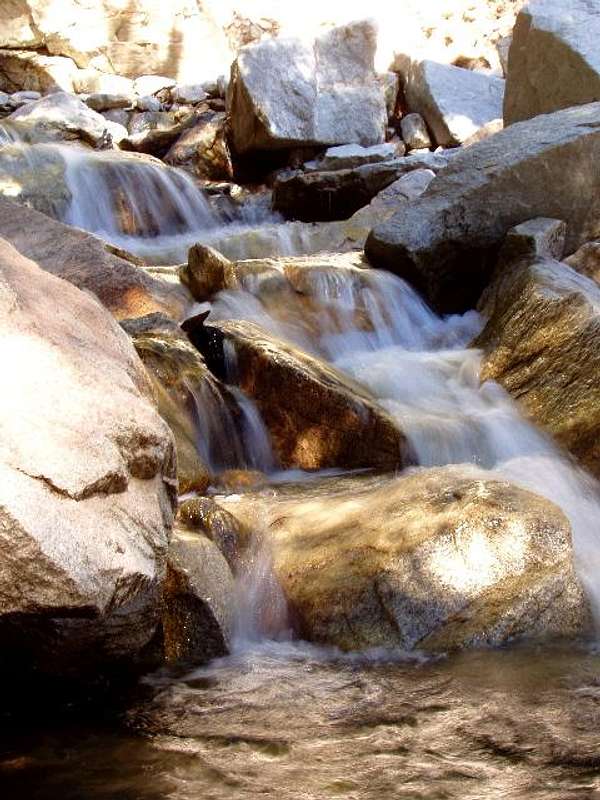
Mill Creek is a major tributary of the Santa Ana River. Its headwaters are high in the San Gorgonio Wilderness on the southern flanks of Mt. San Gorgonio, the highest peak in Southern California at 11,501 feet. Mill Creek flows west through a steep and very scenic canyon in the San Bernardino National Forest. On its way down the creek passes the quaint community of Forest Falls where a picnic area and two wilderness trailheads are located. Falls Creek joins Mill Creek near the town as it tumbles down a waterfall called Big Falls which is the highest waterfall in Southern California at about 500 feet high. Further down the canyon is the hamlet of Mountain Home and the Thurman Flats Picnic Area which is a pleasant spot to have lunch and explore the creek. The Mill Creek Canyon abruptly terminates near the Mill Creek Ranger Station and the creek continues downhill through a broad valley. Mill Creek's confluence with the Santa Ana River is near Greenspot Road in the Mentone/East Highlands area.This is an geologically active area... the San Andreas Fault runs through the Mill Creek area where it branches into the Mill Creek Fault near the mouth of the canyon. Rock slides and flash floods in the canyon are common. This is also an active area for bighorn sheep and other wildlife including mule deer, mountain lions, bobcats, foxes, coyotes, and bears. As far as vegetation goes the lower elevations are covered by chaparral and the higher elevations by oak, incense cedar, sugar pine, ponderosa pine, and bigcone douglas fir. Sycamore trees, willow, and alder are common along the creek itself.

Getting There
From I-10 in Redlands take the Highway 38 exit and go east through Redlands and Mentone. Just after Bryant Street and the Mill Creek Ranger Station the highway enters the canyon and ascends alongside the creek until you get to the Forest Falls turnoff. Here to continue up the canyon take Valley of the Falls Drive to the right. This road travels through the small town of Forest Falls and eventually terminates at the Vivian Creek Trailhead. The Vivian Creek Trail follows the canyon upstream for a little bit further before crossing the creek and switchbacking up the steep south-facing slopes of the canyon on its way up to Mt. San Gorgonio.
Red Tape
Adventure Passes are needed for parking at Thurman Flats, Momyer Trailhead, Vivian Creek Trailhead, and Big Falls Picnic Area. They cost $5 for a daily pass, $30 for a yearly. Interagency Annual, Senior, and Access Passes are also accepted. All passes may be purchased at the Mill Creek Ranger Station. They also can be purchased online and from local vendors. See this website for more information.Wilderness Permits are needed for hiking in the San Gorgonio Wilderness. They are free but there is a quota so it's recommended you request your permit in advance, especially if your trip is on a weekend. This can be done up to 90 days in advance of your trip. For holiday weekends the earlier the better! Or if you're hiking up Vivian Creek on a Saturday, definitely get your permit in advance because this trailhead quota often fills.
Campfires are never allowed inside the wilderness. Campfire restrictions may be in effect elsewhere as well. See this website for the current info.
Dogs must be leashed on trails inside the wilderness.

Camping
There is no car camping in Mill Creek Canyon. The nearest car campgrounds are further up Hwy 38 at Barton Flats or down Bryant and Oak Glen Roads at Yucaipa Regional Park.There are a few wilderness campsites on the rim of the canyon including Vivian Creek Camp and Alger Creek Camp... see the website for the San Gorgonio Wilderness Association for more information on these and the trails leading to them.
External Links
Mill Creek Ranger Station, San Bernardino National ForestSan Gorgonio Wilderness Association
NWS Weather Forecast for Forest Falls

Mill Creek History
"In 1810 a party of missionaries, Indian converts, and soldiers were sent out from San Gabriel Mission to establish a station between San Gabriel and the Colorado River. This party came into what is now San Bernardino Valley on May 20th, the feast day of San Bernardino of Sienna, according to the Roman Calendar of Saints, and the valley was named in his honor.A small mission was established that prospered well until the terrific earthquakes of 1812 and destroyed the buildings and terminated all missionary activities for years.
In 1822 the Guachama ranchita of Indians appealed to the San Gabriel Mission for assistance, and a priest was sent out who helped erect an adobe chapel and aided in the construction of the Mill Creek Zanja, [ditch] which has been in use ever since. During the turbulent years that followed, there were many Indian battles and frequent massacres throughout the valley.
The downfall of the missions began in 1823 with the passage of the Secularization Act when Mexico came to power. As the missions declined, the land was granted under Mexican laws to private individuals who developed into a class that might be called “Cattle Barons.” The Lugos, Sepulvedas, Yorbas, Isaac Williams, Michael White, and Louis Robidoux were men of this class; and during the “gold rush” days, when meat was at a premium, they were as “flush” as the miners in the north.
It was during the War with Mexico in 1846 that the famed Mormon Battalion made up of five hundred volunteers, started out on one of the longest infantry marches in history. Theirs was a two thousand mile trek across uncharted deserts and mountains of California, by way of Santa Fe and Yuma. They arrived in San Diego in January of 1847, too late to lend much military assistance. Among the officers of the battalion were such men as Jesse Hunter, Andrew Lytle, and Jefferson Hunt, -all of whom later became prominent in the affairs of San Bernardino. When the men of the Mormon Battalion were mustered out of the service a short time after their arrival, a few of them started a chain of events destined to open up a new era for San Bernardino and her mountains.
Jefferson Hunt may well be called the “Father of San Bernardino County,” and he was the first Mormon fully to appreciate the climactic and agricultural possibilities of Southern California. Following his discharge from the battalion and prior to his return to Utah, he visited much of California from San Diego to the gold fields in the north.
In 1848-49 he led the first wagon trains into Southern California from Salt Lake City by the southern route through the Cajon Pass.
It was from his 1849 caravan that the ill-fated Death Valley party separated. There is no question but what the entire would have reached Los Angeles in safety, if they had not chosen to go against his advice and search for a short cut to the coast.
In March of 1851, shortly after California was admitted to statehood, a party of five hundred Mormons departed from Salt Lake City with an oxen wagon caravan. It was Brigham Young’s plan to establish a colony in Southern California to be used as an outfitting post for overseas missions.
The whole group was under the command of Amasa M. Lyman and Charles C. Rich, but the party was divided into three groups under the leadership of Captains Hunt, Seeley and Lytle (hence Seeley Flats and Lytle Creek). Three months later, the three groups were camped close to the Cajon Pass and were ready to select a site for their new city. Their first thought was to locate on the hills east of the present city of San Bernardino, thus the name City Creek. The present location of the city was finally chosen because of an abundance of feed for their stock.
They finally purchased, for $7500.00, a thirty five thousand acre tract from San Bernardino Rancho, formerly owned by Antonio Maria Lugo. Then began the Herculean task of laying out ranches, developing water systems, a building a self-sufficient community. In 1852 Colonel Henry Washington, a United States Deputy Surveyor, erected a monument on top of San Bernardino Peak and from it ran the base line from which a future Southern California surveys and subdivisions were made. H. G. Sherwood, who made the original surveys for Salt Lake City, also made the surveys for the city and county of San Bernardino. It was in 1853 that the one mile square town site of the city was laid out in Babylonian style –a miniature Salt Lake City.
As the Mormons began to erect homes and buildings, the demand for lumber increased. For a time the only supply was from a small mill in Mill Creek Canyon that was run by water power."
From: http://www.southerncaliforniamountains.com/history.html