
-
 12493 Hits
-
 88.51% Score
-
 27 Votes
|
|
Mountain/Rock |
|---|---|
|
|
46.62702°N / 12.38889°E |
|
|
Bolzano Alto Adige/Veneto |
|
|
Hiking, Mountaineering |
|
|
Summer |
|
|
9993 ft / 3046 m |
|
|
Overview
Geographical classification: Eastern Alps > Dolomites > Dolomiti di Sesto > Monte Popèra
Monte Popera 3046 m
What's New on this Page?
* Jul 28, 2017 - Ownership switched by andrea
*Jul 31, 2017 - Page under review
* Aug 22, 2017 - Started the overhaul of the page (added chapters, added map and restored the links to the huts)
* Sep 27, 2017 - End of the overhaul
The Popèra group is a broad and articulated complex of mountains formed by a succession of toothed ridges, spires, bell-towers, massive and rounded summits, separated by deep and steep valleys, named "le buse". Monte Popera 3046 m - Hochbrunnerschneid in German - is a mountain belonging to this sector of the Dolomiti di Sesto (Eastern Dolomites), located South to Cima Undici, just on the Veneto/Bolzano Alto-Adige border ridge, between Val Popera on the Eastern side (Veneto) and Val Fiscalina on the Western side (Bolzano-Alto Adige). It's the second summit in order of height of the group, after Cima Undici, and shows very different aspects depending from the various sides.
On the side of Val Fiscalina it offers an interesting route which is the most accessible and attended to summit the peak. The Normal route is situated on the West side and begins a hundred meters below "Forcella Giralba" 2431m, which is located exactly on the border. On the east side it's situated the Refuge "Berti", at the foot of the mountain, useful for rock climb routes or the Via Ferrata "Aldo Roghel". Popera, a “belvedere“, which offers a magnificent view of the surrounding mountains: this is what the guide called "Hochturist" wrote in the 1929, also describing the normal climb to the summit. At that time, the “Busa di Dentro” probably hosted a glacier which remains today in shape of a small snowfield, as evidenced by the presence of moraine debris along the itinerary. The summit consists of a long and rounded ridge North-South oriented. Its continuation to the North is joined to the "Cima Undici" by a long rocky ridge furrowed on the east side by a deep rift and is known as "Cresta Zsigmondy".
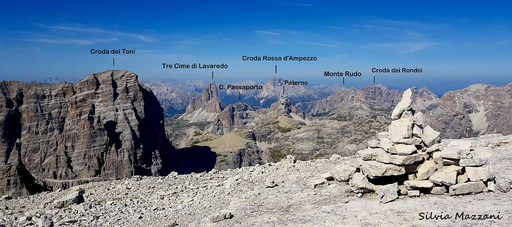
Monte Popèra annotated summit view - ph. Silvia Mazzani
Il gruppo Popèra è un complesso ampio e articolato di montagne formate da una successione di creste dentate, guglie, campanili, massicce e arrotondate cime, separate da profondi e ripidi valloni, chiamati "le buse". Il Monte Popera 3046 m - Hochbrunnerschneid in tedesco - è una montagna appartenente a questo settore delle Dolomiti di Sesto (Dolomiti Orientali), situata a sud di Cima Undici, proprio sul confine tra il Veneto e Bolzano Alto-Adige, tra la Val Popera sul versante orientale (Veneto) e la Val Fiscalina sul versante occidentale (Bolzano-Alto Adige). È la seconda cima in ordine di altezza del gruppo, dopo Cima Undici, e presenta aspetti molto diversi a seconda dei vari versanti.
Sul versante della Val Fiscalina offre un percorso interessante che è il più facile per raggiungere la vetta. La via Normale è situata sul versante Ovest e inizia cento metri sotto la "Forcella Giralba" 2431 m, che si trova esattamente sul confine. Sul versante Est è situato il Rifugio "Berti", ai piedi della montagna, utile appoggio per le vie di arrampicata o la Via Ferrata "Aldo Roghel". Popera, un "belvedere", che offre una magnifica vista sulle montagne circostanti: questo è ciò che la guida chiamata "Hochturist" scrisse nel 1929, descrivendo anche la normale salita in vetta. A quel tempo, la "Busa di Dentro" probabilmente ospitava un ghiacciaio, che oggi rimane a forma di un piccolo campo di neve, come dimostra la presenza di detriti morenici lungo l'itinerario. La sommità è costituita da una lunga e arrotondata cresta con orientamento Nord-Sud. Verso nord è unita alla "Cima Undici" da una lunga cresta rocciosa solcata sul lato Est da una profonda spaccatura, nota come "Cresta Zsigmondy".
Monte Popera is bordered to the north by the "Cima Undici", on southwest to the "Monte Giralba" and southeast to the "Cima Bagni". Secondary peak is the "Cima Popera" 2964 m bristling of spires and pinnacles above Vallon Popera. Popera doesn't stand out amongst the other mountains for grandeur or size, but anyway it has an impressive rock wall dropping down the East side above the "Vallon Popera" and a scree basin on the West side, the Busa di Dentro, where it runs the Normal route.
Along the South East ridge,specifically on the "Forcella fra le guglie", passes a Via Ferrata named "Aldo Rogel" that connects two important sides of the mountain. Popera is the meeting point of several ridges of the massif: Zsigmondy and Giralba to the south and southwest, Cima Bagni to the southeast and Croda Rossa and Cima Undici to the north and northeast. The whole massive was the scene of harsh fights during the First World War, especially the Cima Undici.


Il Monte Popera confina a nord con la "Cima Undici", a sud-ovest con il "Monte Giralba" e a sud-est con "Cima Bagni". Una cima secondaria è la "Cima Popera" 2964 m irta di guglie e pinnacoli sopra Vallon Popera. Il Popera non si distingue tra le altre montagne per grandezza o dimensioni, ma ha comunque una parete rocciosa impressionante che scende dal lato Est sopra il "Vallon Popera" e una conca detritica sul lato ovest, la Busa di Dentro, dove si trova la via Normale.
Lungo la dorsale sud-est, in particolare sulla "Forcella fra le guglie", passa una via ferrata denominata "Aldo Rogel" che collega due lati importanti della montagna. Il Popera è il punto d'incontro di diverse creste del massiccio: Zsigmondy e Giralba a sud e sud-ovest, Cima Bagni a sud-est e Croda Rossa e Cima Undici a nord e nord-est. L'intero massiccio fu teatro di aspri combattimenti durante la prima guerra mondiale, in particolare la Cima Undici.

History
The first summiters were M. Holzmann and Santo Siorpaes in the year 1874. The first ascent through the North glacier (wrongly called "east wall") was performed by Oscar Schuster with H. Moser in July 8th 1893, while the North-East wall was climbed by G.M. Mayer, Angelo Dibona, Luigi Rizzi and Ignaz Schranzhofer in August 26th 1911.I primi salitori furono M. Holzmann e Santo Siorpaes nell'anno 1874. La prima salita attraverso il ghiacciaio Nord (chiamata erroneamente "parete est") fu effettuata da Oscar Schuster con H. Moser l'8 luglio 1893, mentre la parete Nord-Est fu salita da G.M. Mayer, Angelo Dibona, Luigi Rizzi e Ignaz Schranzhofer il 26 agosto 1911.
Getting There
Monte Popera is situated in the Eastern sector of the Dolomiti di Sesto, a group of mountains on the border between Alto-Adige (West) and Veneto (East) counties. The road approach can be done from both sides.
From Alto Adige: Sesto - Val Fiscalina - Refuge Comici
From Veneto: Giralba - Val Giralba - Refuge Carducci - Forcella Giralba Padola - Val Risena - Refuge Berti - Ferrata "Aldo Roghel"/Passo della Sentinella.
The village of Sesto is located along the Valle di Sesto, a branch of the larger Val Pusteria. From Autobrennero motorway exit Bressanone and take the Val Pusteria, following the indication "Val Pusteria/Dobbiaco". Pass Dobbiaco and after the village of S.Candido/Innichen turn to right towards Sesto/Sexten, reaching Sesto, then Moso. In Moso turn to right to Bagni di Moso and Val Fiscalina. For who comes from the Veneto side, motorway A4 from Milano or Venice, motorway A27 to Belluno, SP 52 to Auronzo di Cadore and indications to Giralba or Padola.
Access to the Refuge Zsigmondy-Comici
From the parking lot in Val Fiscalina 1454 m (paying parking) take the flat gravel road, closed to private cars, to the Capanna di Fondo Valle 1526 m, where the road ends. Here take to the right of the valley a well worn mule-track.
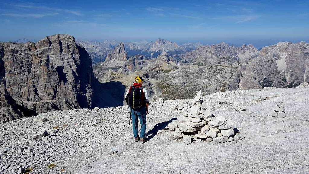
After a bit ignore the trail to the Refuge Locatelli-Innerkofler on the right and continue on the main path, crossing the Sassovecchio river on a wooden bridge and getting the base of the walls of the Cima Una. With bends and some horizontal stretches the path climbs up on the right of the valley (orographic left) with magnificent views to the surrounding mountains. With a last series of steep hairpins it reaches the Refuge Zsigmondy-Comici 2224 m, situated in an attractive position facing a circle of imposing mountains, including the magnificent North wall of the Croda dei Toni.

Il Monte Popera è situato nel settore orientale delle Dolomiti di Sesto, un gruppo montuoso al confine tra le contee dell'Alto Adige (Ovest) e del Veneto (Est). L'avvicinamento stradale può essere effettuato da entrambi i lati.
- Dall'Alto Adige: Sesto - Val Fiscalina - Rifugio Comici
- Dal Veneto: Giralba - Val Giralba - Rifugio Carducci - Forcella Giralba Padola - Val Risena - Rifugio Berti - Ferrata "Aldo Roghel" / Passo della Sentinella.
Il paese di Sesto si trova lungo la Valle di Sesto, un ramo della più ampia Val Pusteria. Dall'autostrada Autobrennero uscire a Bressanone e prendere la Val Pusteria, seguendo l'indicazione "Val Pusteria / Dobbiaco". Oltrepassare Dobbiaco e dopo l'abitato di S.Candido / Innichen svoltare a destra in direzione Sesto / Sexten, raggiungendo Sesto, poi Moso. A Moso svoltare a destra per Bagni di Moso e Val Fiscalina. Per chi proviene dal Veneto, autostrada A4 da Milano o Venezia, autostrada A27 per Belluno, SP 52 per Auronzo di Cadore e indicazioni per Giralba o Padola.
Accesso al Rifugio Zsigmondy-Comici.
Dal parcheggio in Val Fiscalina 1454 m (parcheggio a pagamento) si prende la strada sterrata pianeggiante, chiusa al traffico privato, fino alla Capanna di Fondo Valle 1526 m, dove termina la strada. Qui si prende a destra del vallone una mulattiera ben battuta. Dopo un po 'ignorare il sentiero per il Rifugio Locatelli-Innerkofler sulla destra e proseguire sul sentiero principale, attraversando il fiume Sassovecchio su un ponte di legno e giungendo alla base delle pareti della Cima Una. Con tornanti e alcuni tratti orizzontali il sentiero sale sulla destra della valle (sinistra orografica) con una magnifica vista sulle montagne circostanti. Con un'ultima serie di ripidi tornanti si giunge al Rifugio Zsigmondy-Comici 2224 m, posto in bella posizione di fronte ad una cerchia di imponenti monti, tra cui la magnifica parete Nord della Croda dei Toni.


Normal route across the Busa di Dentro
Monte Popera Normal Route across the Busa di Dentro
Summit: 3046 m
Difficulty: Alpine F
Exposure: West, then NW
Difference in level: 820 m. from Refuge Zsigmondy-Comici
Starting point: Refuge Zsigmondy-Comici 2224 m

Route report
From the hut follow the signpost to the saddle called Forcella Giralba on a path crossing a broad scree and skirting the foot of the impressive North wall of Croda dei Toni 3094 m. Without reach the saddle, leave the main path thereabout the “Lago Ghiacciato” 2326 m - often dried - and turn left following the signposts "Monte Popèra" and "Strada degli Alpini". The itinerary passes near the tiny lake and quickly reaches a second signposted junction. Ignoring the left branch leading to the "Strada degli Alpini", the route keeps on along the right branch, entering onto the Busa di Dentro, a broad valley located between Monte Giralba and Cresta Zsigmondy and closed by the West wall of Popera.
The trail climbs up the Busa di Dentro (cairns), reaching a small snowfield at the head of the valley: what remains of a biggest ancient glacier which in the past occupied the amphitheater, as evidenced by the clear morainic remains. Here the valley, blocked by the high rocky wall, is turning sharply to the left. The route climb up steadily on the wide gully, which is often snow-covered until late summer and descends from a high rocky notch on the crest between Popèra and Forcella Alta di Popèra. In the upper part, the itinerary exits the gully to the right and climbs up a slope formed by ledges, steep scree and easy rocky steps (I UIAA, cairns) leading to the broad North West ridge of the mountain. Follow it rightwards getting quickly the wide summit (cross and book). A second summit covered by various cairns is situated 200 meters to the South. For people coming from the refuge Carducci, just crossed the Forcella Giralba, the itinerary keeps the right side. After few meters it joins the previous route. Same way for the ski route.
Descent - reverse the same route


Relazione
Dal rifugio si segue il segnavia fino alla forcella detta Forcella Giralba su sentiero che attraversa un ampio ghiaione e costeggia i piedi dell'imponente parete Nord della Croda dei Toni 3094 m. Senza giungere alla sella si lascia il sentiero principale nei pressi del “Lago Ghiacciato” 2326 m - spesso in secca - e si svolta a sinistra seguendo le indicazioni "Monte Popèra" e "Strada degli Alpini". L'itinerario passa in prossimità del laghetto e raggiunge in breve un secondo bivio segnalato. Ignorando il ramo di sinistra che porta alla "Strada degli Alpini", il percorso prosegue lungo il ramo di destra, entrando nella Busa di Dentro, ampia valle situata tra il Monte Giralba e la Cresta Zsigmondy e chiusa dalla parete Ovest del Popera.
Il sentiero risale la Busa di Dentro (ometti), raggiungendo un piccolo nevaio alla testata della valle: quel che resta di un più grande ghiacciaio antico che in passato occupava l'anfiteatro, come testimoniano i evidenti resti morenici. Qui la valle, bloccata dall'alta parete rocciosa, piega bruscamente a sinistra. Il percorso sale costantemente sull'ampio canalone, spesso innevato fino alla fine dell'estate, e scende da un alto incavo roccioso sul crinale tra Popèra e Forcella Alta di Popèra. Nella parte alta l'itinerario esce dal canalone verso destra e risale un pendio formato da cenge, ripidi ghiaioni e facili gradini rocciosi (I UIAA, ometti) che conduce all'ampia cresta Nord Ovest del monte. Si segue verso destra superando velocemente l'ampia vetta (croce e libro). Una seconda vetta coperta da vari tumuli si trova a 200 metri a sud. Per chi proviene dal rifugio Carducci, appena attraversata la Forcella Giralba, l'itinerario mantiene il lato destro. Dopo pochi metri si ricongiunge al percorso precedente. Stesso modo per la pista da sci.
Discesa: per lo stesso percorso


Popera is not a frequently climbed mountain and its few visits have been made mostly by the Normal route. We mention here the mainly climbing routes thoroughly with the warning that they are all little or nothing attended.
North-East gully - Oscar Schuster with H. Moser, July 8th 1893
East wall - Angelo Dibona with Guido and Max Mayer, Luigi Rizzi and J. Schranzhofer 1911
Hanging Glacier - Celso Gilberti, R. Spinotti e L. Chiussi, 1927
West wall - G. Del Vecchio e M. Mauri, 1947
Il Popera non è una montagna salita frequentemente e le sue poche visite sono effettuate principalmente lungo la Via Normale. Citiamo qui sotto le vie principali di salita con l'avvertenza che sono tutte poco o per nulla frequentate.
Canalone nord-est - Oscar Schuster con H. Moser, 8 luglio 1893
Parete est - Angelo Dibona con Guido e Max Mayer, Luigi Rizzi e J. Schranzhofer 1911
Ghiacciaio sospeso - Celso Gilberti, R. Spinotti e L. Chiussi, 1927
Parete ovest - G. Del Vecchio e M. Mauri, 1947


No fees no permits required. The road to Rifugio Fondo Valle is not allowed to private cars. Together with the adjacent mountains, Popèra is located in the Tre Cime Natural Park established in the year 1980, with an area of 11,000 hectares. The park is bordered to the north by the Val Pusteria, to the east from the Sesto valley, to the south from the border with Belluno and to the west from the Val di Landro. These park is located inside the Dolomiti Settentrionali – Northern Dolomites, one of the nine areas of the Dolomites acknowledged as UNESCO World Heritage Site. More info on SP in my article: Dolomites, living mountains.
Nessuna regola e nessun permesso richiesto, a parte il divieto di percorrenza della strada per il Rifugio Fondo Valle per le auto private. Insieme alle montagne circostanti, il Monte Popèra si trova nel Parco Naturale Tre Cime, istituito nel 1980, con una superficie di 11.000 ettari. Il parco è delimitato a nord dalla Val Pusteria, a est dalla valle di Sesto, a sud dal confine con la provincia di Belluno e ad ovest dalla Val di Landro. Il parco si trova all'interno delle Dolomiti Settentrionali, una delle nove aree dolomitiche riconosciute dall'UNESCO come Patrimonio dell'Umanità. Maggiori informazioni su SP nel mio articolo: Dolomites, living mountains.

- Rifugio Zsigmondy-Comici 2224 m Situation: Val Fiscalina Access: from Campo Fiscalino 1454 m 2/2.30 hours E Owner: CAI sez. Padova Keeper: Nikolaus Happacher Phone: +390474710358 Places: 98 + 6 winter Open from june 30th to september 30th

- Rifugio "Giosuè Carducci" 2297m Situation: Val Giralba Access: from Giralba 951m 3.30/4 hours path n.104 EE Owner: CAI sez. Auronzo di Cadore Keeper: Monti Fabbro Giuseppe Phone +39 347 6861580 Phone: +39 0435400485 Places: 55 + 4 winter Open from 1st july to mid october

- Rifugio Berti al Popera 1950m Situation: Vallon Popera Access: from Selvapiana/Padola 1568m 1 hour path 101 E Owner: CAI sez. Padova Keeper: Fam. Bruno Martini tel. +39 043568031 Phone: +390435/67155 +390435/366104 Places: 56 + 8 winter Open from 25th june to 25th september
When to climb
From June to SeptemberMeteo
ARPAV Dolomiti Meteo


- 3000 delle Dolomiti - Ed. Idea Montagna, Collana "Vie Normali", 2012
- Dolomiti Orientali Vol. I Parte II - Antonio Berti, Collana Guide dei Monti d'Italia
- Maps
Tabacco sheet 010
Wheather Val Pusteria link
Dolomiti Meteo link