
-
 287 Hits
-
 77.48% Score
-
 8 Votes
|
|
Mountain/Rock |
|---|---|
|
|
48.92754°N / 121.56621°W |
|
|
Whatcom |
|
|
Hiking, Mountaineering, Scrambling |
|
|
Spring, Summer, Fall |
|
|
7020 ft / 2140 m |
|
|
Overview
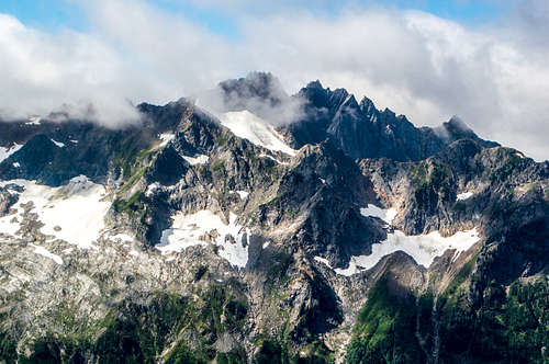
Mount Chardonnay (called Peak 7020 in some forums) is a moderately-sized peak with several long ridges running off it that run down to Noir Peak, Granite Mountain, and Mamie Peak. It's not the most technical or challenging peak in the area, but for moderate bushwhacking and low grade scrambling, it yields impressive views in short distance, and affords some degree of solitude, since it's rarely climbed.
Getting There
From Bellingham, drive east on Hwy 542 to the Hannegan Pass Road turnoff and drive up the Hannegan Pass Road all the way to the parking lot.
Route
From Hannegan Pass Trailhead, hike about 1.3 miles to a large creekbed (dry late season).
Proceed directly up the creekbed if dry, or up the grass slopes and bush west of it if the creek is running. Scramble boulders and dirt to the end of the creek at a waterfall area/ cirque. From the cirque, turn left and scramble up the steep duff/ grass to attain the forest rib that you will be following up to the saddle between Granite and Chardonnay. Crampons and ice axe for dry tooling may be necessary to maintain footing in the duff.
Once through the scrub and branches at the top of the duff slope, scramble and bushwhack up the forest rib, and go left near some cliffs to find a small ledge and some trees to squeeze through to get through the most technical part of the climb. Pass through this zone to reach heather meadows and some slabs, and hike easy terrain to the saddle between Granite and Chardonnay. Enjoy epic views of Sefrit, and Nooksack Ridge.
From the saddle, veer north and weave your way around bumps, knolls, and tree stands, to find easy scree and talus scramble final stretch to Chardonnay summit. At the summit, soak in views of Mount Sefrit, Nooksack Ridge, Mount Shuksan, Mamie Peak, Noir Peak, Church Mountain, Granite Mountain, Hannegan Peak, Ruth Mountain, Goat Mountain, Icy Peak, Tomyhoi Peak, Slesse Mountain, Mount Baker, Nooksack Tower, and many many others
Return via same route (bring rope for the descent back into the creek cirque), or continue toward Granite Mountain and climb Granite, Hannegan Peak North, and Hannegan Peak. Return via Hannegan Pass for an easy finish.
Red Tape
A Northwest Forest Pass is required for each vehicle parked at the Hannegan Pass trailhead. $5 per day or $30 for an annual pass. Where to get PARKING PASSES:
SHELL GAS STATION: in Maple Falls, is on the right (heading East). They make good pretzels too. ---NO GASOLINE AVAILABLE BEYOND THIS POINT!!!--- no gas between Maple Falls and Deming (heading West).
GLACIER PUBLIC RANGER STATION: (360) 599-2714
- On the right (heading East) as you leave the town of Glacier.
Closed for the season after Oct. 11
- Bellingham REI: (360) 647-8955 400 36th St Bellingham. Take a left off exit 252 (WWU-Bill McDonald Parkway), another left, it's in the Haggen lot.
When to Climb
Theoretically could be climbed year-round, depending on snow conditions and when the road melts out, but the approach is entirely on south-facing slopes in an area with notoriously disagreeable weather. So spring, summer, and fall are the safest and most fun times to go.
Camping
Car camping is doable at the trailhead, and there's a small adirondack cabin near the trailhead you can also camp in.
There's many places to camp up on the ridgeline between Mount Chardonnay and Granite Mountain.
Camp spots can also be found on top of Hannegan Peak if you choose to do the big loop back to Hannegan Pass.