
-
 14860 Hits
-
 82.48% Score
-
 15 Votes
|
|
Mountain/Rock |
|---|---|
|
|
32.19080°N / 111.0721°W |
|
|
Pima |
|
|
Hiking, Scrambling |
|
|
Spring, Fall, Winter |
|
|
3330 ft / 1015 m |
|
|
Overview
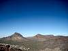
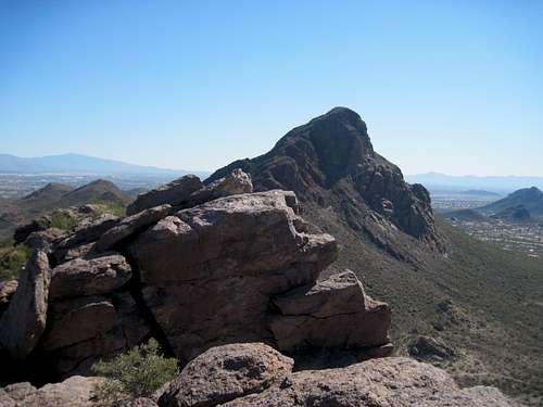
 "Little Cat Mountain" Summit; Golden Gate Mountain in background
While not nearly as striking as its larger sibling to the southeast, Cat Mountain, UN 3,330, nicknamed “Little Cat Mountain,” is a scenic and rustic little peak in the Tucson Mountains west of Tucson, Arizona. Cloaked in a prickly blanket of Sonoran Desert flora, including Cholla and Saguaro, this close-to-town will bring delight to those willing to push their way to the summit.
Unmarred by a formal trail, the hiker must brave a steep, rocky and very faint footpath through vampire desert plants to reach the top of “Little Cat Mountain.” A surprisingly airy perch greets the visitor to the apex of this petite desert peak: The western slopes of “Little Cat Mountain” drop abruptly to the floor of the Sonoran Desert, while hot desert air rushes up to the summit block.
Views from the top include the Gates Pass area peaks Golden Gate Mountain and Bren’s Benchmark, but the best treat of all is the gnarly hulk of big sibling Cat Mountain rising from the desert floor to the southeast.
AZ Rank: 4,765th highest peak in Arizona
Prominence: 420 feet
USGS Quad: Cat Mountain
Trails Illustrated Map: #237 Saguaro National Park
Getting There
 Gates Pass
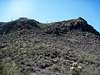 East side
Tucson Mountain Park resides 13 miles to the west of Tucson, Arizona in Pima County. The park can be reached via Gates Pass Road or by taking Ajo Road to Kinney Way.

Red Tape
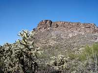 "Little Cat Mountain" from desert below
 "Little Cat Mountain" from west of "Los Gatos Pass"
There is no entry fee for Tucson Mountain Park. The park is open daily 7:00 AM to 10:00 PM. Click here for full rules governing use of Pima County Parks.
Camping
 Stand of Saguaros
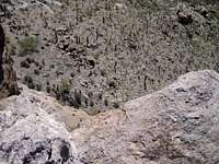 Looking down to the desert floor
The only nearby campground is the 130-site Gilbert Ray Campground, located in Tucson Mountain Park.
The proximity of “Little Cat Mountain” to the Tucson Metro area means lodging options are virtually unlimited. Visit the Trip Advisor site covering Tucson, AZ, for more information about area accommodations.
Weather & Seasons
 Airy Summit Perch
 Sonoran Desert Cholla
As with most lower elevation hikes in the Tucson area, hiking "Little Cat Mountain" would be most comfortable in the fall, winter or spring. March and April are primo wildflower viewing months.
Summer temperatures in this part of the Sonoran desert can be worse than uncomfortable; they can be downright dangerous! According to the United States National Weather Service, the record high temperature for Tucson, Arizona, set on 26th June 1990, was 117 degrees Farenheit / 47 degrees Celsius.
| Month | Avg High | Avg Low | Rain |
|---|---|---|---|
| January | 64.5 F | 38.9 F | 0.99 in. |
| February | 68.4 F | 41.6 F | 0.88 in. |
| March | 73.3 F | 45.1 F | 0.81 in. |
| April | 81.5 F | 50.5 F | 0.28 in. |
| May | 90.4 F | 58.6 F | 0.24 in. |
| June | 100.2 F | 68.0 F | 0.24 in. |
| July | 99.6 F | 73.4 F | 2.07 in. |
| August | 97.4 F | 72.4 F | 2.30 in. |
| September | 94.0 F | 67.7 F | 1.45 in. |
| October | 84.0 F | 57.0 F | 1.21 in. |
| November | 72.3 F | 45.1 F | 0.67 in. |
| December | 64.6 F | 39.2 F | 1.03 in. |
External Links
Tucson Mountain ParkPDF Map of Tucson Mountain Park
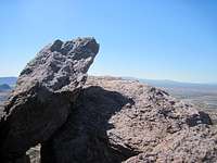
 "Little Cat Mountain" summit, big sibling in background