
|
|
Mountain/Rock |
|---|---|
|
|
46.99410°N / 11.34580°E |
|
|
9665 ft / 2946 m |
|
|
Overview
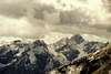
A mighty limestone mountain with an impressive northern wall allowing excellent panorama view on the Staubai mountains. Since the stone is very crumbly, climbing is somewhat tricky and exhaustive but nevertheless easy (not harder than UIAA I at the most). Some of the fixed ropes are in fact not properly fixed, so take care!
The first part of the ascent is below the north face of the wall, so snow and firn should be expected in the early month of the year (which might make the ascent much easier).
Not to many people are climbing this mountain. When we have been there, we met nobody (except one person which was on ascent from the hut which we believe has never reached the summit ;-).
 |  |  |  |  |
Getting There
From Innsbruck in Austria (Airport) you take the highway towards Brenner (italian/austrian border) or even better the country road (which cost no toll) until you reach Steinach (in Tyrol). A small valley to Gschnitz branches westwards which is driven as far as it is allowed (Gasthof Feuerstein - parking).
Red Tape
No fees, no closures. Since the summit (and parts of the trail) belong to the italian/austrian border, a passport should be taken along (occasionally italian customs officers are met).
When To Climb
During summer (June to September). The austrian Tribulaun hut is open from June til September), the italian tribulaun hut is open from July til September. Both huts have a winter room. Climbing in winter might be possible (though I have no detailed information on the conditions) though avalanges are frequent in this region. The austrian hut has been destroyed twice !!
Camping
The whole area is a national park which prohibits camping, possibly bivouaking is allowed. Sleeping is of course possible in the Tribulaun huts.
Mountain Conditions
The phone number of the austrian Tribulaun hut: +(A) 5222 / 38451. (Homepage)
The phone number of the italian Tribulaun hut: +(I) 472 / 762470. (Homepage)
Information should be available here.
Information on alpine weather is found here: Wetter
Route description
From Gschnitz in the Gschnitz valley (Gasthof Feuerstein - 1242 m) one gets left (southwards) to the trail towards the austrian Tribulaun hut which is reached within 2 to 3 h (2064 m). The Gschnitzer Tribulauns sends a mighty wall towards this hut, the ascent is on the left hand of this wall. 20 min on a marked trail and exhausting further 500 vertical meters on crumbly stones lead to the Schneetalscharte (2642 m). From there with scrambling (occasionally fixed ropes, some of them are loose - attention!!!) to the top.
An alternative ascent can be done from the italian side, e.g. from the italian Tribulaun hut. This trail goes as well over the Schneetalscharte.
Guides, Books, Maps
The recommended guide is the "Alpenvereinsführer" "Stubaier Alpen - alpin" by Walter Klier (Bergverlag Rother) (New edition April 2002?)
ISBN: 3-7633-1271-4 (Description; order at Amazon.de)
A guide describing various climbing routes in this area is written by Andreas Orgler: STUBAIER ALPEN - Fels & Eis
ISBN: 3-926807-21-0 (Description; order at Amazon.de)
A good map is sold by freytag & berndt (Innsbruck Stubai - Sellrain Brenner 1:50000, WK241).
ISBN:3-85084-753-50 (Description)
The Alpenvereinskarte is - in this region - not significantly more useful (31/3 Brennerberge 1:50000)
50 (Description)
Tourist Information
Tourist information can be found here:
tourist information Steinach Trins Gschnitz
First Ascent
G. Pittracher with tourists before 1872
Climbing
Several climbing routes are described in Orglers book (vide supra).
External Links
- Walking around the Gschnitzer Tribulaun
A lot of pictures taken during a hike in the Gschnitzer Tribulaun area
- Austrian Map online
Online digital maps of Austria (OEK 50, OEK 200 and OEK 500) by the BEV (Bundesamt für Eich- und Vermessungswesen) - in German
JoPo - Sep 8, 2004 11:53 am - Hasn't voted
Untitled CommentThank you for your comment. What was the rest of the trail like? When I climbed this mountain there was no trail over the steep slope which made it very exhausting. Is it well prepared meanwhile?
haraldag - Sep 14, 2004 7:34 am - Hasn't voted
Untitled CommentI am not quite sure, but I assume you mean the way up to the "Schneetalscharte". Well, there was some kind of path, but since the rock is very loose here I guess the path vanishes or changes every few weeks. It was exhausting for us too, and I think this won't change in the future.
JoPo - Sep 14, 2004 9:45 am - Hasn't voted
Untitled CommentYes, that's what I meant. Thank you!
haraldag - Aug 23, 2004 10:12 am - Hasn't voted
Untitled CommentI visited this mountain on August 22nd 2004. The ropes looked to be very new and were very tightly secured. So the information given in the "AVF Stubai" seems to be outdated.
JoPo - Sep 8, 2004 11:53 am - Hasn't voted
Untitled CommentThank you for your comment. What was the rest of the trail like? When I climbed this mountain there was no trail over the steep slope which made it very exhausting. Is it well prepared meanwhile?
haraldag - Sep 14, 2004 7:34 am - Hasn't voted
Untitled CommentI am not quite sure, but I assume you mean the way up to the "Schneetalscharte". Well, there was some kind of path, but since the rock is very loose here I guess the path vanishes or changes every few weeks. It was exhausting for us too, and I think this won't change in the future.
JoPo - Sep 14, 2004 9:45 am - Hasn't voted
Untitled CommentYes, that's what I meant. Thank you!