
|
|
Mountain/Rock |
|---|---|
|
|
49.60381°N / 18.82336°E |
|
|
Hiking, Skiing |
|
|
Spring, Summer, Fall, Winter |
|
|
3209 ft / 978 m |
|
|
Intro
If you have any information which is missing, please let me know.
Thanks a lot.
Stożek Wielki (pol)/ Velký Stožek(cz)/ Big Cone(engl) is a mountain located on the borderline between Poland and Czech Republic. Third highest in Czantoria Massif/ Cantoryje Massif after Czantoria itself (995 m) and a neighbour of Stożek- Kiczory (990 m).
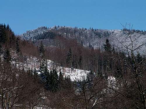 Stożek from Zimny
Very characteristic mountain, easy to recognize from both sides. Name takes after its „conical” shape. Besides Czantoria/ Cantoryje, Stożek is most frequently visited peak in Czantoria Massif. Very popular among Polish hikers because of the hut located slightly below the top (at 957 m) and wide panorama from the meadow near the chalet. Because of the trees the view is now not so wide as it was some years ago but it’s still one the best viewpoints in Silesian Beskidy.
Towards east (from north to south):
- Klimczok (1119 m) Massif with Magura (1095 m)
- Skrzyczne (1257 m)Group with Malinowska Skała (1152 m)
- Barania Gora (1220 m) Massif with Babia Góra (1725 m) peaking above the ridge in the distance
- Lipowska (1324 m) and Romanka (1366 m) with Pilsko (the second highest peak in Beskidy- 1557 m) in the distance
- ridge of Tatras
- Kiczory (990 m)- the neighbour of Stożek.
Stożek- 978 m
Stożek is a peak located in main ridge of Silesian Beskid (Beskid Śląski/ Slezske Beskydy).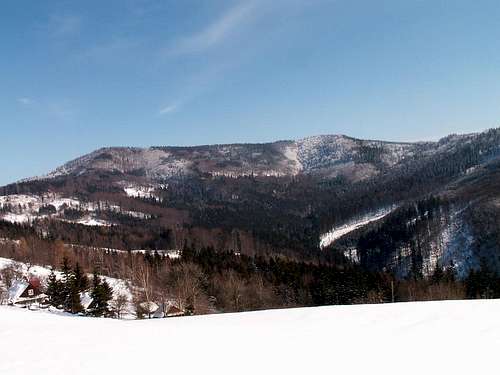 Stozek and Kiczory
Ridges:
The ridge to the north goes to Cieślar (920 m), Soszów Wielki/ Velky Sosov (886 m) and further to Czantoria/ Cantoryje (995 m – the highest mountain in Czantoria Massif).
Continuing south the main ridge turns east to the peak of Kiczory (990 m) and then through Mrozków goes to Kubalonka Pass (761 m) the border between Czantoria Massif and Pasmo Wiślańskie.
Stożek has also four shorter ridges:
- south- culuminates in Bystry (721 m)
- west- with Gronicek (832 m)
- north- west- the longest one- with two other peaks: Filipka (762m) and Loucka (835 m)
- north- east- goes to Kobyła (802 m).
Valleys:
Stożek rises above two bigger valleys:
- Łabajowa Valley between main ridge and north-east- Polish side. Through the valley goes green marked route. There are located: famous bridge at the entrance of the valley and two small (K65 and K35) ski jumping hills.
- Hluchova Valley between main ridge and north- west- Czech side. Through the lower parts of the valley goes yellow marked trail (to Sosov), through the upper- green marked path (from Filipka to main ridge between Stożek and Cieślar).
On its slopes grow beech and coniferous trees.
On the top of nearby Kiczory there’s a small group of sandstone rocks called “Mushroom rocks” up to 8 meters high. Similar sandstone rocks are on Kobyła- up to 15 meters high and 62 meters long.
 Sandstone rocks on the top of Kiczory
Skiing
Stożek is the biggest ski center in Wisła. The slopes are located on the north-east side of the mountain.3 ski trails:
- easy: 1600 meters
- medium: 800 meters
- hard: 1100 meters
Chair lift: 800 meters long, 248 meters of altitude difference. Three smaller ski lifts (one for children).
Snowpark for snowboarders (free).
Contact:
ON Stożek
43-460 Wisła Łabajów
ul. Zjazdowa 11
Fax: +48 33 855 32 04
Phone: +48 33 855 32 52
email: stozek@narty.pl
Official site: weather forecast, webcam.
Routes overview
Stożek is climbable from all sides.Marked routes which lead to the top of Stożek:
From Poland:
- 1. from Wisła Głębce through Kiczory by blue marks- 2,5 h.
- 2. from Wisła Głębce through Łabajowa Valley by green marks- 1 h 45 min. There’s also possibility to go by bus to the last bus stop in Łabajowa Valley and from there to the top- 1 h.
- 3. from Jaworzynka through Istebna village and Kiczory- 4 h. There’s also another possibility to reach the top of Kiczory from Istebna- by green marks.
- 4. from Wisła Dziechcinka through Kobyła by blue marks- 1h 45 minutes.
- 5. from Wisła Dziechcinka by yellow marks- 2,5 h.
- 6. from Czantoria through Soszów/Sosov by red marks- 3 h.
- 7. from Kubalonka through Kiczory- 2,5 h.
 On the trail...
From Czech Republic:- thanks to Gorzi
Three most often used routes from the Czech side:
- 1. Navsi, railway station - two variants: over the Filipka or directly to the top of Stozek.
- (1) Navsi, railway station - yellow marked trail -
Rohovec - Filipka (767 m) - red marked trail - Pod Stozkem - yellow marked trail - at the crossroad steeply to the
right - blue marked trail (on the Czech-Polish frontier) -
Velky Stozek (978 m) - (2) Navsi, railway station - non-marked route - along the road heading towards Jablunkov. We are passing by U Mrozka pub, and then we take the third branch to the left (almost in Jablunkov). Behind this branch are: on the right side, on the top of a small hill, there is a chapel, and on the left, there is a police station. We are going up this road, all the way in the direction of Stozek, and when we finally reach a forest, there will be a crossroad. One way go straight, another to the right down, and the third to the left. We can go straight up, but the left route is better. We are following this route all the way to the hamlet of Zimny. There stands a building of Hotel Stozek, but it is currently out of order. From this hotel we can go straight up to the ridge above this hotel, and there we met a trail leading from Filipka (red marked). On the ridge we turn right and further as in previous description.
Another variant of a route from this Hotel: we can go to the right through the hamlet in the direction of Grunicek and Bahenec; red marked trail. At the first crossroad (above a wooden chalet) we turn right (left branch leads to the "meeting point" with Filipka´s route). We are following this trail to the point called Grunicek (832 m). From there we follow the blue marked trail (to the right leads a red marked trail to Bahenec). We are steeply ascending through the woods, up to the another crossroad on the Czech-Polish frontier. To the right leads a trail to the summit of Kycera/Kiczory (990 m), and to the left to the summit of Stozek (987 m), with a Polish hut on its top.
- 2. (3) Jablunkov, Radvanov - yellow marked trail - Grunicek (832 m) - blue marked trail - Velky Stozek (987m).

Another routes to the summit of Velky Stozek:
- Hradek, railway station - green marked trail - Chata na Gruni hut - Filipka - further as in previous descriptions
- Jablunkov, Pisecna - blue marked trail - Hotel Bahenec - red marked trail - Grunicek - blue marked trail - Stozek.
- Bukovec - red marked trail - Ostra hora (727 m) - Bahenec - further as in previous description.
Getting there
From Poland:The nearest airport is in Katowice.
Wisła is the nearest city- from there starts the majority od marked trails. Wisła is located about 80 km south from Katowice. Accesible by car, train and bus.
Polish railways(official)
Buses in Wisła
From Czech Republic:- thanks to Gorzi
To Navsi, where is a railway station (Jablunkov-Navsi), you can go by train from all the Czech Republic and from Slovakia, because it is located on the most important railway line in this region: Kosice (SK) - Bohumin (CZ). The nearest airport is in Ostrava-Mosnov. You can go there by car too: Navsi is located on the international road nr. E75.
Trains and buses
Trains and buses (English)
Trains and buses (German)
Accomodation/ camping
 Stożek from Kiczory
In Poland:
There are many possibilities for finding a place to sleep in Wisła. People offers cheap rooms, there are also few places with rooms of higher standard i.e. Hotel Gołębiewski.
Official site of Wisła
Rooms are also available in the hut near the top of Stożek:
SCHRONISKO STOŻEK
43 - 460 Wisła, ul. Turystyczna 19,
Phone/fax:: +48/33/ 855 27 10
e-mail: stozek@poczta.onet.pl
Info about the hut
In Czech Republic:
Rooms are available in Jablunkov and nearby cities and villages.
Official site of Jablunkov
Hotel Bahenec- near the trail to Stozek:
HOTEL BAHENEC
Pisek 195
739 84 Pisek
Ceska republika (CZ)
Phone: (+420) 558 330 057
Red tape
There are no red tapeException: Natural reserve „Bystry”.
Emergency
 Mushroom rocks on Kiczory
In Poland:
Górskie Ochotnicze Pogotowie Ratunkowe- GOPR
Stacje Ratunkowe - Wisła
Adresses:
Ul. Malinka Street 8
phone number: +48 33 855 36 07
Ul. Cieślarów 30
phone number: +48 33 855 28 32
Ul. Kiczory
phone number: +48 33 855 27 85
Emergency number in the mountains:
+48 601 100 300
GOPR (Beskidy) official site
GOPR (main) official site
In Czech Republic:
Dům HS
Ul. Ondřejnická 896
739 11 Frýdlant nad Ostravicí
Phone/fax: 558 677 393
Phone numbers:
597 431 700
597 431 701
Emergency number: 606 769 010
Horska Sluzba(Beskydy) official site
Horska Sluzba (main) official site
When to climb
Stożek is climbable all year round.Weather forecast and webcam
Webcam
Essential gear:
Best time for hiking is summer season: June-September. In summer no special equipment is needed.
In winter conditions: casual equipment for hiking in winter. Expect a lot of snow.
Maps
There are many maps available in book-shops.Online Maps:
Map of Czech Republic (with zoom)
Map of Beskidy
Links
Some links providing info about whole area:Czech Rep:
CeskeHory.cz
Beskydy-info.cz
Polish:
Beskidslaski.pl
E-szlak.beskidy.pl