
|
|
Mountain/Rock |
|---|---|
|
|
28.86219°N / 90.13540°E |
|
|
Mountaineering |
|
|
19777 ft / 6028 m |
|
|
Overview
 Summit
General info
There are four peaks in the Noijin Kangsang area which can be considered as peaks in the true sense of the word. The rest are by most standards highpoints on ridges. Apart from the 7206m giant which has given the name to the group you find Kaluxung, Jangsunglhomo (6325m) and Jitanzhoma. The latter is a rocky, windswept and far-away peak in the west of the group. Long ridges lead to its summit from the NE and a glaciated face are located in the W. A long beautiful valley terminates below the rocky bastions on the E side and if the snow conditions are good this may be the most interesting way to the summit ridge. The ridges are long slogs on loose scree and gravel and are not recommended. The route described on this page is a snow couloir climb with a gradient up to 50 degrees. Most of the way it's much less steep and my guess is that it's an average of perhaps 35 degrees. More about this on the route page.
 View of Kaluxung's west pillar
Views!
E - Fantastic views of Kaluxung's W pillar.
SE - Gyalungsum's pyramid with sharp ridges is amazing.
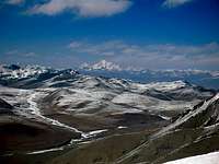
S - The central Himalaya can be seen far away.
N - Noijin Kangsang's massive bulk seems to be so near.
NNW - On a clear day you can see Qungmoganze's pyramidic shape far away.
Panoramas
More detailed info about what you can see in the south on Viewfinderpanoramas.
Getting There - Lhasa
 Noijin Kangsang from the summmit
It's unlikely you start from anywhere else but Lhasa, so here are some alternatives how to reach the capital on the roof of the world.
Nowadays there are many ways to reach Lhasa and it's often much simpler than the general information says.
By air
Domestic direct flights to Lhasa departs from Chongqing, Chengdu and Shangrila/Zhongdian. These places can be reached from lots of other Chinese cities and connections from for example Beijing, Shanghai and Hong Kong are good.
There's also a direct international flight from Kathmandu (Nepal) to Lhasa.
Overland - Bus
Long, hard rides from wherever you choose to arrive from.
From the north - go by train instead, unless you like sharing a crowded space with chain smoking, altitude sick people for a ride which seems to go on for ever.
From the west - It takes 58h from Ali/Shiquanhe and another 30-35 from Kashgar. Long and hard.
From the east - lots of travel restrictions from this side. You have to travel with a combination of many buses in order to reach Lhasa from any of the eastern provinces.
From the south - at present it's a bit hard for westerners to travel with the direct bus from the Nepali border. In the other direction it's not a big problem though.
 Summit ridge
Overland - Train
It's said to be the most advanced railway ever built. Can't comment that, but it takes you over some 5000m passes and the scenery of the northern plateau is a real beauty.
The official website about the train.
Overland - Landcruiser
Mostly used for the travel in between Nepal and Lhasa. Hundreds of travel agencies can arrange all the necessary papers for your travel to Tibet and a vehicle. The price for an overland trip from Nepal to Tibet is slightly cheaper than travel by air.
Overland - other ways of transport
Lhasa is an adventurous destination and of course it therefore attracts adventurous travelers. Many cycle or hitch to Lhasa, which of course both are nice ways if you really want to see what's along the way.
Getting there - to Jitanzhoma
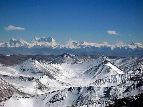 Himalaya far away
Going to the area
You can either rent a Landcruiser which takes you all the way to the mountain massif or go by local transport. The former is about 700Y/100$. Minibuses for up to 6-7 people are cheaper - 500Y. Tell the driver to let you off close to Karo La, the 5000m pass close to the valley where you start walking to the peak. The spot is obvious. A wide valley opens up on your left and the road takes off to the right - this is the place.
Local buses headed for Gyantse is another alternative. It's dirt cheap. About 35-40Y and takes about 4h. You can also go with buses to Nakartse, but then you have another 25km to hitch before you reach the valley leading to the peak.
Leaving the area.
Unless you have pre-arranged a pick-up or have a phone number to a Landcruiser service, the only way to get out is by hitch hiking. It's easy. Almost every car stops in these desolate areas. Make sure to set the price before getting into the vehicle. All the way to Lhasa it shouldn't be more than 100Y/person.
Red Tape
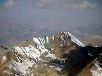
 Gyalongsum seen from Jitanzhoma
You need a visa for China. Easy to pick up in any Chinese embassy. Usually they can issue visas with validity times up to three months. Price varies on your nationality.
The long term visas before available in Hong Kong are now gone. At least this is the case at the time writing (2008 02 03).
Chinese embassies
You also need a Tibet permit.
Reading on the www it can seem as a huge problem to get this permit, but it's not. If you buy a train ticket, you have to get the permit as well and any ticket office/travel agency which can sell you a ticket to Tibet can also sell you the permit. The same applies for airline tickets.
Getting the permit for overland travel with a land cruiser is easy, as the organizing part then takes car of the permit procedure as well.
Be careful about how much you pay for the permit though. It's usually between 350 and 500 Yuan Renminbi (roughly 7 to the US$). Many agencies charge much, much more!
You can also go there without a permit. Most backpackers do and get away with it. The Tibet permit is hardly ever checked inside Tibet. That said, I have heard about a very few cases (2) where travelers without permits got thrown off the train in the city of Golmud, so there's a slight risk.
Coming to Lhasa/Tibet from Nepal other rules apply. You have to be in an organized "group" tour. The group can be only you, but it's still called a group journey. Many Nepalese agencies can arrange the whole deal for you form Kathmandu. Shop around. Prices differs a lot. Also, if you plan to travel from Nepal to Tibet, don't bother to get a Chinese visa beforehand. It'll be canceled in Kathmandu anyway and substituted with a new "special group tour visa".
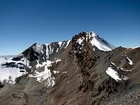
 Jitanzhoma seen from 6550m on Kaluxung
You also need a climbing permit from the CTMA (Chinese Tibetan Mountaineering association. The peak fee for Jitanzhoma is $750. The CTMA office is located in Himalaya Hotel in central Lhasa.
China Tibet Mountaineering Association
No 8 East Linkhor Road
Lhasa, Xizang/Tibet, China
Tel: +86-891- 6333687
fax:+ 86-891- 6336366
e-mail: ctma@public.ls.xz.cn
Camping
 View from half way up
Camping is the only alternative in the area. Beautiful campspots are to be found everywhere and water is plenty.
Be careful with the local shepherds and nomads. They are not to be trusted when it comes to stealing gear.
An alternative route
 The alternative ridge route
Bruno adds:
The long NE ridge might offer an interesting alternative and can be accessed from the same valley at the pass 5732m (28°51'59.90"N/90° 8'53.60"E) between P5830m (28°51'58.60"N/90° 9'9.30"E) and P5861m (28°52'8.50"N/90° 8'39.40"E).
Mountain conditions & when to climb
 Looking down
You can climb Jitanzhoma any time, but the winter months can be bitterly cold. Himalayan winds may threat to blow you off the summit ridge and frost bite is a grim reality. Dress for arctic conditions.
During the other three seasons the climb can be done with normal high altitude gear.
One thing to remember is that the area is infamous for ferocious winds. In summer the described couloir may be free from snow, which makes this nice route a boring slog on steep scree. Better go for the glacial northern approaches in that case. Even the long NE ridge may be a better alternative.
Water
 Frozen lake
Water is plenty in the area. Streams from glaciers and snow fields are all around. Just be careful drinking it as there are quite a lot of yaks and goats in the area during the warmer periods of the year. In winter you may have to hack a hole in the ice of the frozen rivers.
Provisions & gear for sale/rent
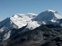
 Noijin Kangsang S pillar
Lhasa is full of well stocked super markets. By Chinese standards they're amongst the most expensive in the country, but used to western prices the costs are low. For those which every cent matters - try the whole seller shops on the east end of Beijing Dong Lu.
There are some good gear shops in Lhasa. Outlook Outdoor on Beijing Dong Lu is one of the better. On the road where Snowlands Hotel is located leading to Barkor Square there are plenty of shops selling fake stuff. One of China's top brands, Shehe has a shop on North Lingkor Road. Anything from matches to down suits can be found here.
China's other top brand - Ozark has a shop on Beijing, but the employees are doing their absolute best to be super rude and discourage anyone to buy anything.
Places to stay
 In the couloir
Lhasa
Lhasa has hundreds of hotels. Some of the old Tibetan favorites in the center include Tashi Tangkay, Snowlands, Kirey, Banak Shol and Yak. All of these have a good location close to the places you want to visit in Lhasa. A better option than all the above is Phuntsok Khasang, which has clean, cheap rooms for 2$ and up.
A slightly upmarket place which has a good reputation is the silent Eagle Land Guest House just out of the center.
Ask around - there's a place for all tastes and wallets.
Nakartse
There are three basic, over priced places to stay in this little one street town about 25km from the peak. Don't expect much.
Gyantse
As the city is quite a popular destination for tourists there are some ok hotels in the city center.
Peaks in the same area


Acclimatization
 Qungmoganze from summit
Arriving in Lhasa at 3700m directly from sea level is a nasty experience for many people. Relax in the city for a couple of days, drink lots of fluids and don't push it.
A good idea is to hike one of Lhasa's trekking peaks. If you feel alright on one of the higher mentioned on that page, you'll be fine heading for Jitanzhoma.
The whole area is high and the place where you start walking is at about 4900m. If you arrive here too early you may experience symptoms of AMS or worse.
Map of the area close to the peak
 Map showing the peak and the area around it
Maps & guide books
 Map of the area
There are lots of maps of Lhasa itself and also of Tibet. The ones in the former category are usually good as long as you get an updated copy. Maps of Tibet are usually very bad. They may look nice, but errors are extremely common and plenty. Mostly it's wrong names, wrong altitude, showing non existing roads etc.
Map of central Lhasa.
Here are two links to lists with maps for the area:
Omnimap.
The Map Shop.
Here's the best and only really good one of the mountain massif itself.
Another place to buy it
[img:380333:alignleft:small:Map of the area]
There are few good guides for the area.
One which deals with general planning for the little bit more seasoned traveler is the guide book from Trailblazer.
More specifically for trekking, try McCue's Trekking Tibet.
Links
Great info about high altitude related problems.Lhasa travel guide. Lots of good info about the city and travel in the area.
Travel agency in central Lhasa which is used to deal with unusual mountaineering requests..
A traveler's portal for Tibet.
Wikitravel for Lhasa.
Wiki about Lhasa.
Wiki about Tibet.
Wiki about China.
Bruno - Mar 15, 2008 7:57 am - Voted 10/10
East couloir and alternative routeThanks Janne for this excellent page on an additional unknown Tibetan peak. As you mention in your page, the described route (East Couloir) is free of snow in the warmer month, especially in its lower section (see this picture from October 2007). The long NE ridge might offer an interesting alternative and can be accessed from the same valley at the pass 5732m (28°51'59.90"N/90° 8'53.60"E) between P5830m (28°51'58.60"N/90° 9'9.30"E) and P5861m (28°52'8.50"N/90° 8'39.40"E).
Corax - Mar 23, 2008 1:58 am - Hasn't voted
Re: East couloir and alternative routeThanks for the info. I will put it on the main page.
Bruno - Mar 29, 2009 12:36 pm - Voted 10/10
Another possible routeI guess the glaciated West face of Jitanzhoma would offer another alternative route. At least it looks quite feasible according to this picture.
Corax - Mar 30, 2009 8:42 am - Hasn't voted
Re: Another possible routeFrom where is that photo taken more exactly? The easiest way to the summit must be the one Eran and Fredrik tried. The long walk on the ridge. You were up there as well if I remember correct? This photo indicates that. Eran and Fredrik turned back though, as they thought they were on the actual summit. A little remark. The GPS reading on the summit was 6028m and it was a good one. I think the map is off.
Bruno - Mar 30, 2009 10:46 am - Voted 10/10
Re: Another possible routea)Shot location of North face picture: Lat 28°54'15"N Lon 90°07'25"E, alt. approx. 4800m, on the road approx. 5-6km below Karo La b)Shot location of Northeast ridge picture: small summit 5830m Lat 28°51'58.6"N Lon 90°09'09.3"E. The NE ridge and the west face (or ridge) are really two dinstict routes, you can see the NE ridge (green) and W face (red) in this GE image and that GE image. I am not sure what route they take in their attempt, but I guess they ascended from the west (route in red). You can find P5830m on this picture (GPS 5830m, map 5816m). I also added a similar photo taken from the north, where the west face is better visible(right side of the picture). About the altitudes, I also got systematically higher GPS readings in the area (e.g. Kaluxung 6686m instead of 6674m), but in the new area/range page I am working on right now, I preferred to use the altitude given by the map for better clarity for the reader. In the pictures, I'll try not to forget to put both altitudes.
Corax - Apr 6, 2009 1:05 pm - Hasn't voted
Re: Another possible routeThanks for the extensive information. I didn't know Jitanzhoma looks that impressive from that side.