
|
|
Mountain/Rock |
|---|---|
|
|
42.86910°N / 72.2925°W |
|
|
Hiking |
|
|
Spring, Summer, Fall, Winter |
|
|
962 ft / 293 m |
|
|
Overview
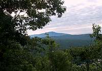
Looking for an obsure summit that has a great 180 pamorama and is never crowded? If you want a quick summit with a pretty view that VERY FEW people know about check out this little summit. The little summit itself has a great view of Mount Manadnock and well as much of the other summits in the area including both Franklin and Gunn Mountain. It also contain a New England style view of the village of Swanzey nestled in the hills.
The summit contains a number of historic notes. Freeman Ceasar a freed slave is what the summit is named after. The summit was also one of many summit in the area used a Native American lookout. The trailhead itself starts in a historic cemetary right across the street from the Swanzey.
The walk up itself is nothing more that a 1.5 mile gradual class 1 that travels from the back of the cemetary (watch where you park). In order to get to the trail park in the cemetary so that others can go can by. Head to the to the very right back corner of the cemetary and start on the trail the trail will merge will a jeep path about 0.2 mile up the trail, Make a left and stay on that jeep path to the summit. THere is a side trail which descends from the summit moderately to a ledge with views of Mt. Monadnock.
I would imagine this would a semi-popular hike during Halloween due to the nature of the trailhead starting at a cemetary.
Getting There

Getting here was probably more a challange than the actual hike..
VIA TRAILHEAD IN THE CEMETARY: From Keene take Route 12 south from Route 101. ABout a mile south turn on Route 32 towards Swanzey. Pass the Go-Kart track and the school area and then on the semi T intersection make a left and stay on Route 32. THe cemetary is right across the street from town Hall and the road is symboled by white gates (nothing fancy). Watch where you park!!!
Red Tape
None, just park in such a a way that others can make it through the cemetary. I would guess that the cemetary is closed at night.Camping
THough I didn't see any signs I'm sure the cemetary is closed at night. Take note that this trail can be done a little more than an hour leaving little reason to camp.Trail Conditions
Here are some websites that will provided you more information on conditions on Mount Ceasar. Focus on all of the information for the lower mountains.Appalachian Mountain Club
Current Trail Conditions

royswkr - Oct 16, 2006 11:48 pm - Hasn't voted
Caesaris the spelling used on the USGS map, library, etc. - should probably be changed here to help search engines