
|
|
List |
|---|---|
|
|
Fill in the Blanks Game
There's a lot of ?s on this page at the moment where I haven't been able to find information. If you can help me out please add any info under 'corrections/addition' or PM me. Thanks.
Overview

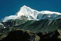
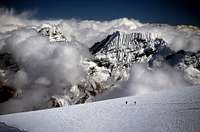
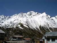
At the final ridge of Imja Tse SE normal route
The next step up beyond hiking is to tackle one of the 18 mountains designated as trekking peaks. The category was created by the Nepal Mountaineering association as an intermediate stage between hiking and all-out mountaineering. They are often close to major peaks, with astounding views from their summits. Climbing them gives you the exhilaration of pitting yourself against Himalayan conditions and altitudes. It is essential to note that these are still considerable mountains, taller than almost anything in North America or Europe. Don’t be fooled by the name ‘trekking peak’ - most classic routes require a little scrambling over snow and ice so make sure you are familiar with the use of crampons and ice axes. The peaks also have plenty of potential for more experienced Alpinists looking for tougher challenges. The north face of Cholatse for example is a serious undertaking not to be taken lightly.
Regulations
Regulations pertaining to trekking peaks are relatively simple. A permit is required which is issued by the Nepal Mountaineering Association on payment of the royalty fee. This fee depends on whether the peak is in group A or group B. Group B consists of the original 18 trekking peaks and Group A consisits of a further 15 trekking peaks introduced in 2002, some of which shouldn't really be called trekking peaks because they require a solid base of mountaining skills. Cholatse for example was downgraded from full expediton status. The permit simply allows you to climb the mountain and other bureaucracies such as perchase of trekking permits are still applicable.
Fee structure for group "A" NMA peaks
Royalty for up to seven members: US $ 500
Royalty for each additional member up to 12 persons: US $ 100
Fee structure for group "B" NMA peaks
Royalty for 1-4 members: US $ 350
Royalty for 5-8 members: US $ 350 + US $ 40 per person
Royalty for 9-12 members: US $ 510 + US $ 25 per person
Note : Maximum number of members in one team is 12
The Nepal Mountaineering Association have produced a small booklet containing the regulations governing the ascent of trekking peaks. There are certain requirements governing trekking peaks, such as the need for a registered sirdar and for a recognized agency to get your peak permit.
An amount of $250 must be deposited with NMA as garbage deposit to get a permit. This is refunded on the basis of a satisfactory report jointly signed by the concerned team leader, sirdar and climber.
One advantage of Nepal is that mountaineering gear is readily available in Kathmandu - but not as cheaply as it used to be! The Maoist troubles are a possible deterrent to climbing in Nepal. However in general the vital importance of tourism to Nepal is well-understood, and mountaineers are not interfered with, although there have also been a few stories of money being demanded or cameras taken. The situation varies from month to month so try to get up-to-date information before you go.
Climbing Grade
Listed peaks are graded using the Alpine Grade system. The overall seriousness of the complete route based on all factors of the final approach, ascent, and descent—including length, altitude, danger, commitment, and technical difficulty. This system originated with UIAA Roman numerals; it is now generally seen with French letters and is increasingly being used worldwide. Grades described below are for the 'classic' route ascent lines. Alternative routes will obviously be of a higher grade.
F: Facile/easy. Rock scrambling or easy snow slopes; some glacier travel; often climbed ropeless except on glaciers.
PD: Peu Difficile/a little difficult. Some technical climbing and complicated glaciers.
AD: Assez Difficile/fairly hard. Steep climbing or long snow/ice slopes above 50º; for experienced alpine climbers only.
The original 'B' group trekking peaks are rated no more than Alpine grade AD. Many of the easier peaks also have harder routes that are not listed here. Some of the newly introduced 'A' group peaks are technically harder and are comparable in grade to many "expediton peaks"
I have divided peaks in to their relevant geographical areas and then listed them in order of height.
Annapurna Himal
| Peak | Height (m) | Height (ft) | Alpine Grade | Latitude | Longitude | First Ascent | Royalty Group |
| Singu Chuli (Fluted Peak) | 6501 | 21329 | AD | 28o34'48" | 83o52'48" | 1957 | B |
| Hiuchuli | 6441 | 21132 | PD | 28o31'00" | 83o53'00" | 1971 | B |
| Thorong Ri (Khatung Kang Fore) | 6144 | 20157 | PD | 28°46'57"N | 83°55'40"E | ? | N/A |
| Tharpu Chuli (Tent Peak) | 5663 | 18579 | PD/AD | 28°33'44"N; | 83°53'23"E | 1964 | B |
| Mardi Harmal | 5587 | 18330 | F | 28°28'31"N | 83°55'41"E | 1961 | B |
 Thorong Ri |
 Shingu Chuli |
 Tharpu Chuli from Annapurna BC |
 Hiunchuli |
Gaurishankar Himal
| Peak: | Cherigo |
| Height (m): | 6257 |
| Height (ft): | 20528 |
| Alpine Grade: | AD |
| Latitude: | 27°54'23"N |
| Longitude: | 86°24'48"E |
| First Ascent: | ? |
| Royalty Group: | A |
Kangchenjunga Himal
| Peak: | Boktoh |
| Height (m): | 6142 |
| Height (ft): | 20154 |
| Alpine Grade: | ? |
| Latitude: | 27o37'12" |
| Longitude: | 88o00'00" |
| First Ascent: | 1991 |
| Royalty Group: | A |
| Peak: | Peak 5950m |
| Height (m): | 5950 |
| Height (ft): | 19052 |
| Alpine Grade: | PD- |
| Latitude: | 27o80'28" |
| Longitude: | 88o11'33" |
| First Ascent: | ? |
| Royalty Group: | N/A |
The last few meters to the top of Peak 5950
Khumbu Himal
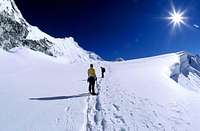
 Mera Peak from the south |
 Mera Peak's Route |
 Upper slopes of Mera Peak, with the Hongu Valley shrouded in cloud. The Kangchenjunga massif can be seen in the far distance |
 Approaching the summit of Mera Peak |
| Peak | Height (m) | Height (ft) | Alpine Grade | Latitude | Longitude | First Ascent | Royalty Group |
| Mera Peak | 6476 | 21247 | PD | 27°42'33"N | 86°52'06"E | 1953 | B |
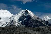
| Cholatse | 6440 | 21128 | ? | 27°55'11"N | 86°45'56"E | 1982 | A |
| Kusum Kangguru | 6367 | 20889 | ? | 27°43'51"N | 86°47'21"E | 1979 | B |
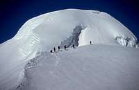
| Imja Tse (Island Peak) | 6183 | 20285 | PD/PD+ | 27°55'12"N | 86°56'5"E | 1953 | B |
| Lobuche East / Lobuje East | 6119 | 20075 | PD+ | 27°57'32"N | 86°47'27"E | 1984 | B |
| Lobuche West / Lobuje West | 6145 | 20160 | ? | 27°58'9"N | 86°46'57"E | ? | B |
| Kongde Ri (Kwangde Ri) | 6011 | 20298 | AD | 27°47'36"N | 86°38'32"E | 1975 | B |
| Khongma Tse (Mehra Peak) | 5849 | 19189 | ? | 27°56'39"N | 86°50'21"E | 1975 | B |
| Pokhalde | 5806 | 19049 | PD/PD+ | 27°55'30"N | 86°50'04"E | 1953 | B |
| Chhukung Ri | 5559 | 18238 | F | 27°55'32"N | 86°52'45"E | ? | A |
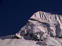
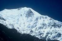
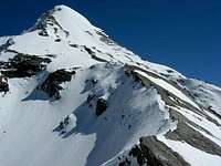
 Island Peak |
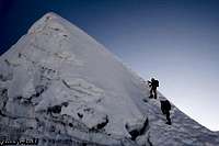
 Ascent of Imja Tse |
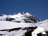
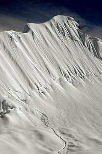 Around 5850m approaching the final ridge on Imja Tse's SE Normal Route |
 Summit of Island Peak |
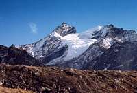
 Lobuche East |
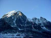
 Kongde Ri |
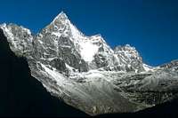
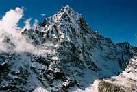 Cholatse |
 Pokalde |
Langtang Himal
| Peak | Height (m) | Height (ft) | Alpine Grade | Latitude | Longitude | First Ascent | Royalty Group |
| Yubra Himal | 6035 | 19800 | ? | 28°6'27"N | 85°34'05"E | ? | A |
| Paldor Peak | 5896 | 19344 | ? | 28o16'43" | 85o11'02" | 1949 | B |
| Gamja La Chuli (Naya Kanga) | 5846 | 19181 | PD | 28o09'00" | 85o35'24" | 1986 | B |
| Yala | 5500 | 18044 | F | 28°14'23"N | 85°37'34"E | ? | A |
 Naya Kanga |
 View NE from summit of Tsergo Ri.Yala peak on the left and the much larger Morimoto Peak on the right |
 Yala Peak from high camp |
Jugal Himal
| Peak: | Langsisa Ri |
| Height (m): | 6427 |
| Height (ft): | 21085 |
| Alpine Grade: | ? |
| Latitude: | 28o12'36" |
| Longitude: | 85o42'36" |
| First Ascent: | 1982 |
| Royalty Group: | A |
Mahalangur Himal
| Peak | Height (m) | Height (ft) | Alpine Grade | Latitude | Longitude | First Ascent | Royalty Group |
| Ombigaichen | 6340 | 20800 | AD/D | 27o51'00" | 86o52'48" | 1960 | A |
| Pharilapcha (Machermo) | 6017 | 19740 | ? | 27°55'44"N | 86°40'51"E | 2003 | A |
| Kyajo Ri | 6186 | 20295 | D+ | 27°54'31"N | 86°40'14"E | 2002 | A |
| Nirekha | 6159 | 20206 | ? | 27°58'38"N | 86°45'48"E | ? | A |
| ABI | 6097 | 20003 | ? | 27°59'5"N | 86°43'9"E | ? | A |
 Kyajo Ri from Machhermo |
 Pharilapcha |
Manang Himal
| Peak | Height (m) | Height (ft) | Alpine Grade | Latitude | Longitude | First Ascent | Royalty Group |
| Chuli East | 6584 | 21601 | PD+ | 28°44'9"N | 84°2'3"E | 1955 | B |
| Chulu West | 6441 | 21131 | PD+ | 28°44'37"N | 84°1'20"E | 1952 | B |
| Pisang | 6144 | 20157 | PD- | 28o38'24" | 84o11'24" | 1955 | B |
 Chulu East |
 Chulu West |
 Pisang Peak |
Rolwaling Himal
| Peak | Height (m) | Height (ft) | Alpine Grade | Latitude | Longitude | First Ascent | Royalty Group |
| Parchemuche / Pharchamo / Parchamo | 6187 | 20298 | PD | 27°50'11"N | 86°32'50"E | 1955 | B |
| Ramdung | 5950 | 19438 | PD | 27°49'7"N | 86°25'52"E | 1952 | B |
Manaslu Himal
Peak: Larkya Peak
Height: 6249m
Alpine Grade: ?
Latitude: 28°38'45"N
Longitude: 84°31'56"E
First Ascent: 1982
Royalty Group: A
Books
The Trekking Peaks of Nepal by Bill O'Connor ISBN: 0898866766
Trekking and Climbing in Nepal by Steve Razetti ISBN: 0811729478
Lonely Planet Trekking in the Nepalese Himalaya by Stan Armington ISBN: 1864502312
Trekking in the Everest Region by Jamie McGuiness ISBN: 1873756607
External Links
Nepal Mountaineering Association
The UIAA - Mountaineering in the Greater Ranges
BigLee - Mar 7, 2007 11:24 am - Hasn't voted
Re: PaldorThanks for that. The Jugal/Langtang thing has always confused me a bit as it appears to be virtually the same subrange. I'll make those changes you mention.
dmiki - Mar 23, 2008 7:37 am - Voted 10/10
correctionsGreat list, thank you for creating this page! Some comments: "one of the 18 mountains designated as trekking peaks" The number should be 33 (18+15), no? (But you have 35 peaks listed on the page. Also the NMA mentions Lobuche West 6145m as a trekking peak as well. I could never figure out the 'correct' number of peaks designated as trekking peaks myself, different sources list different peaks and numbers.) http://www.nepalmountaineering.org/climbingregulation.php -> http://www.nepalmountaineering.org/index.php?razer=climbingregulation (2 broken links) "Mardi Harmal" -> "Mardi Himal" Hiuchuli -> Hiunchuli (I think this is the more common spelling) Cherigo -> Chekijo (I think this is the more common spelling) "Chuli East" -> "Chulu East" Gokyo Peak should not be a child of this page, although it is a 'trekking' peak in the sense of the word, but does not require an NMA permit.
dmiki - Mar 23, 2008 8:19 am - Voted 10/10
Climbing gradesKusum Kanguru is D, Paldor is AD/AD+ Some more info.
Bruno - Aug 30, 2011 12:23 pm - Voted 10/10
Khongma Tse coordinatesBased on the Nepa map and GE, correct summit location is about 1.4km further south at 27°56'39.26"N 86°50'21.32"E. The coordinates given by the ministry of tourism (27°56'24" 86°50'24") do correspond to P5777m located about 1km further south. Edit: wrong coordinates given
Bruno - Sep 2, 2011 1:48 am - Voted 10/10
PharilapchaCoordinates (from Google Earth, crosschecked with map): 27°55'44"N 86°40'51"E Apparently, all pictures posted by SP member reybelo are from the first ascent in 2003. Here another picture of Parilapcha from the South.
Bruno - Sep 24, 2011 6:25 am - Voted 10/10
Some corrrectionsThanks BigLee for maintaining this list, but I think a few corrections are needed: 1) Number of peaks and classification As Dmiki wrote, the total is 33, 15 belonging to group A and 18 belonging to group B. You wrote "Group B consists of the original 15 trekking peaks and Group A consisits of a further 18 trekking peaks introduced in 2002". The number 15 and 18 should be inverted. 2) Lobuje West Lobuje West, which belongs to the B group, is missing from the list. Lobuje / Lobuche West, 27°58'9"N 86°46'57"E, altitude 6145m 3) Wrong coordinates After a rapid check, it seems that several coordinates are wrong, some several hundred km off, some other are confusing minutes with decimal coordinates, some just a few hundred meters off. Here what I hope are the correct ones (but without guaranty!): Thorong Ri (28°46'57"N 83°55'40"E) Tharpu Chuli (28°33'44" 83°53'23") Mardi Himal (28°28'31" 83°55'41") Chekijo (27°54'23 86 24 48) Mera Peak (27°42'33" 86°52'06") Cholatse (27°55'11" 86°45'56") Kusum Kanguru (27°43'51" 86°47'21") Imja Tse (27°55'12" 86°56'5") Lobuche East (27°57'32" 86°47'27) Kongde (27°47'36" 86°38'32"E Khongma Tse (27°56'39"86°50'21") Pokalde (27°55'30" 86°50'04") Yala (28°14'23" 85°37'34") Tsergo Ri (28°12'47"N 85°36'3") Kyajo Ri (27°54'31" 86°40'14") Nirekha (27°58'38" 86°45'48") Chulu East (28°44'9"N 84°2'3"E) Chulu West (28°44'37"N 84°1'20"E) Parchemuche / Pharchamo / Parchamo (27°50'11"N 86°32'50"E) Ramdung (27°49'7"N 86°25'52"E) Larkya (28°38'45"N 84°31'56"E) 4) Missing coordinates Chukhung Ri (27°55'32" 86°52'45") Yubra Himal (?28°6'27" 85°34'05") Pharilapcha (aka Machermo) (27°55'44" 86°40'51") Abi (27°59'5"N 86°43'9"E) 5) Ombigaichen According to Himalayan Database, first ascent was on 18.11.1960 and not in 1962. 6) Larkya Correct altitude should be 6249m and not 6010m. 7) Phari Papchi You have this mountain in your list, as apparently belonging to the NMA-A group, but I can't find it anywhere. The altitude given (6017m) is also the same as Pharilapcha, so it is maybe a duplication. The coordinates also do not correspond to any peak in the Mahalangur Himal, but to Pisang Peak. I think you should remove it from the list. 8) Machermo (6237m or 6273m) This peak appears in the NMA list (Group A) but not in your list. It is also listed in many trekking agencies websites, but most pictures of Machermo do represent Pharilapcha (6017m) (when not confusing with Parchamo). According to the Himalayan Database, Machermo (or Machhermo) is just another name for Pharilapcha (6017m). Most expedition report do mention these two names. So I guess that there is just a mistake by listing both Machermo (6237m) and Pharilapcha (6017m) in their "Group A" peaks, as it is most probably the same mountain, with the lowest altitude being the correct one. The total number of so-called trekking peaks would be 14 (Groupe A) + 18 (Groupe B) = 32. 9) Table It would be nice if all peaks would be presented in the same table format. 10) Spelling It could be nice if the table could mention the alternative spellings used for the same peak, so that it would facilitate the search. E.g. from different maps, or from the NMA website: http://www.nepalmountaineering.org/noticespage-13-NMA%20Peaks
BigLee - Jan 11, 2013 8:00 am - Hasn't voted
Re: Some corrrectionsFinally got around to making these changes. Let me know if any numbers still wrong. The original coordinates were off the Himalayan Index, which are not quite as accurate. Thanks.
Scott - Aug 20, 2013 2:47 pm - Hasn't voted
Chhukung RiBig Lee, Chhukung Ri is sometimes listed as a trekking peak, but apparently this is in error. Kyazo Ri 6186 meters is the actually peak that was supposed to be listed, but apparently someone goofed on the website (or so we were told). According to the National Park, you don't need a special permit for Chhukung Ri, in fact you can purchase a certificate for climbing it (we got one). If you click on the link for Chhukung Ri on the Nepal Mountaineering Association, it actually links Kyazo Ri.