
-
 10599 Hits
-
 71.06% Score
-
 1 Votes
|
|
Route |
|---|---|
|
|
37.56660°N / 90.7333°W |
|
|
11-12 miles round trip |
|
|
Most of a day |
|
|
Walk up along Ozark Trail |
|
|
Approach
This is a great route to the summit of Taum Sauk Mountain whose difficulty falls between the long Johnson Shut-Ins State Park route and the easy ADA route in Taum Sauk Mountain State Park. To reach the trailhead travel souh on SH 21 from Arcadia. The trailhead is located on the right side of SH 21 just south of SH CC (Taum Sauk Mountain State Park access) and the Royal Gorge, a nice little Shut-in through which SH 21 passes.
The best time to do this route is in the spring or fall with the end of October providing some of the best fall colors in the country.
A very good trail map as well of tons of other useful information is available from the Ozark Trail Council.
Route Description
If you don't have the ability to do a car shuttle or simply don't have enough time to attempt the Johnson Shut-ins route, this is another alternative to the easy ADA route to the summit. It is suitable for a long day hike.
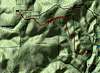
From the trailhead, the trail heads alternately west, north, then west generally following the south slopes of Russell Mountain. SH CC follows the ridge of Russell Mountain from SH 21 to Taum Sauk Mountain State Park. After about five and a half miles you will come to a trail junction. Heading straight follows the Ozark Trail west to Johnson Shut-Ins State Park and turning right heads to the Missouri State Highpoint. Retrace your steps or catch a ride with one of the folks who drove up back to your car.
If you have time, a nice sidetrip to Mina Sauk Falls would be nice, particularly during high runoff or fall colors.
After finishing drive just south on SH 21 through the Royal Gorge, a nice little Shut-in through which Highway 21 passes. There is a parking area on the east side of the highway.
 |
Essential Gear
Although the trail is well marked with the distinctive OT green and white markers, a map and compass should be used on this route.