
-
 17191 Hits
-
 84.82% Score
-
 19 Votes
|
|
Mountain/Rock |
|---|---|
|
|
34.87700°N / 119.1122°W |
|
|
Kern |
|
|
Hiking |
|
|
Spring, Summer, Fall, Winter |
|
|
6848 ft / 2087 m |
|
|
Overview: A Silvery Element
Surveyors in the 1850’s thought they had found silver close to the summit on the north slopes of this 6,848 foot peak. But the extensive deposits turned out to be the silvery, brittle metallic element, antimony. Thus the peak was named.Antimony Peak has a prominence of 888 feet and sits just a couple of miles north of the great San Andreas Rift Zone. This peak is in the California transverse range known as the San Emigdio Mountains. These mountains form the southern wall of the San Joaquin Valley and extend into Kern, Ventura and Los Angeles counties.
The eroded jeep road that provides the main route to the summit was built to access, survey and mine the antimony deposits. Because antimony expands upon solidifying, it has found important uses as an alloy of tin and lead in machine bearings, metal castings and lead-based pigments.
The Class 1 route to Antimony from the trailhead is along a jeep road that descends into a saddle and then around the southwest side of elevation 6670’ dropping into another saddle at 6000’. The road then makes several switchbacks up Antimony’s south slope. At the road’s high point, proceed to the right up the ridge about ¼ mile to the summit.
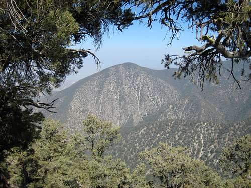
Mt. Pinos (8831') from Antimony Pk
When seen from the north, Antimony Peak is just east (left) of a small notch with a slightly lower bump on the right.

Antimony Pk (back left of notch) seen from Eagle Rest Pk
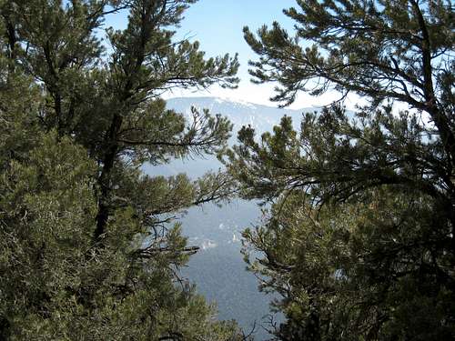
Antimony’s summit is dressed with trees, but the openings between the pines provide rewarding vistas for such a relatively short hike. The highest peak in the San Emigdio range, Mount Pinos at 8831’, is prominently in view to the south, as well as a peak or two to the east overlooking Pleito Creek that don’t have names, but should.
Unnamed peak east of Antimony's summit
The roundtrip is about 5 miles (one person reported that his measurement was a little less than 4 miles) with 900 feet of gain going out and 700 feet on the return.
Sunbather on the summit of Antimony Pk
Getting There
Going north on California Interstate 5, take the Frazier Park exit and turn left. Go 7.2 miles to Lake of the Woods where you continue straight on the Cuddy Valley Road. Proceed 4.2 miles to a dirt road on the right marked by a sign “Tecuya Mtn Rd.”Turn right and proceed as follows: at 1 mile turn left at the fork; at 1.4 miles take
a left at the fork; at 1.9 miles go left on road with sign “9N19A”; at 4.6 miles, there is a large open area where you can park. From the parking area (6660’ elev.), start down on the jeep road that connects there.
Red Tape
No permits or authorization are needed to hike to this peak.
Marker on summit of Antimony Pk
Camping
Several miles away, there is limited camping within the Wind Wolves Preserve (a 97,000-acre private reserve) at San Emigdio Campground and Willow Picnic Area Group Campground. However, the camping is limited to weekend days and requires advance reservations (661.858-1115).When to Climb/Mountain Conditions
This peak can be climbed year round, but come properly equipped when there is snow coverage in the winter. Be sure and check with CalTrans for road condition information during the winter because snow sometimes forces closures along Interstate 5. Furthermore, some roads within the Mt. Pinos Ranger District, including Frazier Mountain Road, are subject to closure during the winter season. Call the Mt. Pinos Ranger District Office 661. 245-3731 for current information.Other Information
USGS Topos Pleito Hills 7.5Cuddy Valley 7.5External Links
Los Padres National Forest Current Conditions.
California Dept. of Transportation
Local weather
Wind Wolves Preserve
digibandit - Oct 31, 2008 9:21 am - Hasn't voted
climbed 10/28/08conditions perfect - came in from Mil Portrero - two of us and dogs (3yr old lab retriever and 14 yrold shep mix) - i betcha Liza is oldest dog to summit.
Augie Medina - Oct 31, 2008 12:09 pm - Hasn't voted
Re: climbed 10/28/08Congrats to Liza. She's quite a strong dog for 14!
14erTramp - Sep 25, 2017 5:33 pm - Voted 9/10
MileageI hiked this route on 9/23/17 and documented the mileage at 3.61; my hiking partner recorded 3.69. I have seen other trip reports/trail blogs with the mileage around 5.0, but I believe it to be shorter. The elevation gain listed here is correct, it is steep with the majority of gain coming between the saddles, about 1mile and on the last 1/2mile return. The road to the trailhead is in good shape, but high clearance advisable. The trail itself is easy to navigate, but there is quite a bit of exposure and a few spots where the track angle has slumped so be watchful of your footing. I recommend trekking poles. The views are quite spectacular and I highly recommend this hike!
Augie Medina - Dec 15, 2017 6:05 pm - Hasn't voted
Re: MileageNote that i've made an edit to the page to reference your measurement.