
-
 2380 Hits
-
 85.36% Score
-
 20 Votes
|
|
Mountain/Rock |
|---|---|
|
|
43.53944°N / 5.64406°E |
|
|
Provence |
|
|
Trad Climbing |
|
|
Spring, Fall, Winter |
|
|
Overview
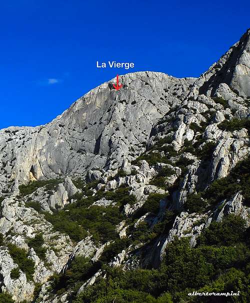
Paroi de la Vierge
Paroi de la Vierge, Virgin's Wall! What's more attractive to climb in the group of the Montagne Sainte-Victoire ? The name is due to a rocky pinnacle looking like a Madonna located on the middle of the S spur. This superb wall is one of the finest rock structures of this wide massif situated in the South of France, a symbol of Provence, like the Sainte-Baume and Mount Ventoux, the major landmark of the Aix-en-Provence region. A huge rocky bastion 18 kilometer long with a 7 kilometer long summit plateau. This charmer massif perfectly visible from afar exerts an extraordinary appeal with its immaculate rocks when it appears in the distance from the plains, even more closely. The highest point is the Pic des Mouches at 1011 m, while the well known summit called Croix de Provence (945 m), with its 19 metres high cross, although not placed at the highest point of the mountain, stands out from the ridge far more than the Pic des Mouches. It's a popular hiking destination, like several other places in the massif, which can be explored along its countless paths, also to look at the fascinating sites of religious heritage, as the Saint-Ser Hermitage, a tiny chapel surrounded by wonderful scenery, or the Sainte-Victoire Priory.
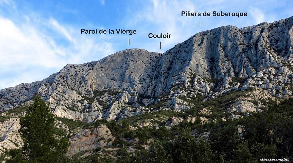
Paroi de la Vierge and Suberoque annotated view
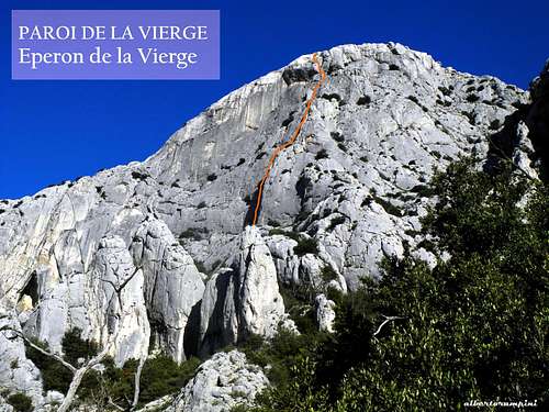
A perfect area for walking, but even more to climb. The rock climbing destination at Sainte Victoire is the South face, which counts around 1000 routes, 29 or more sectors and 7 separate parking lots, an astounding space to climb up a surprisingly sticky limestone. There are a lot of single pitch routes, but also high walls, plenty of long and adventurous climbing routes. The Paroi de la Vierge is one of these latter. With its stunning South wall, it constitutes one of the best climbing destination of the Sainte Victoire massif. There are different routes on the wall, Éperon de la Vierge is one of the most classic routes. Relatively long, partially equipped, compact and continuous, it's just a fine route.
Getting There
By plane - Sainte Victoire massif is situated 35 km from Marseille and 180 km from Nice, so the best option is to fly to Marseille or Nice and rent a car.
By car - The nearest town is Aix-en-Provence. The A8 autoroute runs south of Sainte Victoire and Aix-en-Provence. If coming from the Nice direction, exit the A8 onto the RN 7 in the direction of Aix. From Aix, take the "Route de Cézanne", road D17, which traverses under the south side of the massif from Les Tholonet to Puyloubier. There are several parking lots along this road, the right one to climb on Eperon de la Vierge is located on the left (direction Puyloubiere), after the cross road to Rousset.
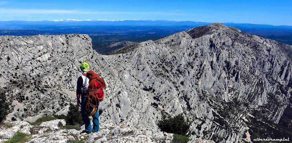
Summit view
Éperon de la Vierge route report
Eperon de la Vierge - French scale
Summit altitude: 1009 m
Difficulty: 6a max (French scale)
Route length: 180 m
Exposure: South First ascent: Claude Eyguesier et Louis Paul, 1944
Starting point: road to Puyloubiere, Parking du Collet de St. Pierre
Sainte Victoire worthwhile classic climb. Partially equipped with spits and pegs. Beautiful setting and interesting slabs in the 2nd and 5th lenghts.
 |
 |
Approach
The approach is a bit complicated. From the parking lot of Collet de St Pierre (P4) follow the track starting towards NE, then at the first junction after a hundred meters take its first branch on the left full North direction. After about 600 m you reach a large left bend, continue on the forest road W direction getting a first small shoulder, with a branch 50m further. Here there are two possibilities:
- or take the path to the right, which is longer. When you reach the brown path, you follow it for a few minutes to descend into a small valley and go up a small path to the right. - either continue about a hundred meters on the forest road - recommended solution - getting a left turn (cairn), here take the narrow path on the right rising up in the bottom of the valley and joining a path with brown marks

Take the brown path, pass a rocky bar and just after take the left path joining a horizontal path. Take this latter in the left direction (West), skirting the Piliers de Subéroque and arriving under the Couloir de Subéroque, situated between the Piliers de Subéroque to the right (East) and the Paroi de la Vierge to the left (West). Overcome a brief rocky wall with the aid of an iron chain (yellow arrow, delicate on the descent, abseil possible), then follow a steep scree leading to the bottom of the Couloir de Subéroque.

|
")
|
A path to the left allows to get the foot of the wall. The route is on the right of the face, just to the left of the pillar. One sees the fix of the second length beside a crack. The route starts inside a wide crack occupied at mid height (6 m) by a large shrub (1 hour from the parking lot).
Climbing report
L1 - Climb the crack or, alternatively, the slab (4c) to the left of the crack. No pegs in place. Belay on a tree, 3b, 25 m.
L2 - Continue in the crack (6a or A0), some fix and old pegs. Belay on fix and a tree, on a small terrace definitely to the left of the crack, 6a, 25 m.
L3 - Return back in the crack on the right and follow the crack, belay on fix near a tree, 5b
L4 - Climb the crack again getting a ridge, 5b
L5 - Climb a dihedral to the left or directly the right slab (fix), 5b, 30 m.
L6 - Traverse a few meters to the left to get the crack on the right edge of a roof. Climb this crack, then traverse left to the last equipped belay.

|

|

|
Descent
There are three possibilities:
- On foot down the Couloir de Subéroque. From the summit head to right (East) towards the Couloir de Subéroque. Downclimb along the couloir, then there's an optional 10 meter abseil on fix and another 25 meter abseil on a tree. Beware of falling rocks if there are people.
- On foot down the Grand Couloir, easier but longer. From the summit head to right (East) towards the Couloir de Subéroque, pass the exit and continue by walking on the wide summit plateau to get the exit of the Grand Couloir. Descend the path of the Grand Couloir (scree, then chains and cable) to join a large scree at the bottom.
- By abseiling on the route "l'Amour en Danger"
Essential gear
Rope 2x50, helmet, harness, a set of excentrics and a set of cams, slings, hammer in case
Other routes on Paroi de la Vierge
Pousse pas l’Aiguille
La Constitution
Arête de l'Ogive
Directe de l'Eperon</>

|

|
Red Tape
No fees, no permits required. There is a strict prohibition to hike and climb during the summer, because of the fire hazard due to the high heat and dryness, usually between June 15 and September 15. Check in every year the exact period before embarking on a vacation, since it may undergo changes. Wild camping is prohibited.
Nature and climate
Montagne Saint Victoire has been recognised as a Grand Site de France since 2004 and is a jewel of natural heritage which must be preserved.

|

|
Covering 35,000 hectares near Aix-en-Provence and Marseille, the Concors and Sainte-Victoire massifs form the largest single wooded area in the department of Bouches du Rhône. Climate is typically Mediterranean, characterized by a great dryness with high sunshine. The area is sometimes subject to the strong wind from the northwest, the "mistral".

When to Climb
In addition to being prohibited, climbing in summer is not advisable in reason of the excessive heat. You can climb also during the winter, but sometimes the weather can be cold and windy. Definitely the best periods on St. Victoire are spring and autumn months.
Where to stay
There are different places to stay close to Montagne Sainte Victoire. We can find equipped campsites in Puyloubier, Beaurecueuil,Rousset and Peynier:
- Camping Sainte-Victoire (Beaurecueil)
- Camping Le Devançon (Peynier)
- Camping Le Cézanne (Puyloubier)
- Camping du Coteau de la Marine (Rousset)
Alternatively Gites are available in St. Antonin and Puyloubier and Hotels in Puyloubier, Rousset, Peynier, Fuveau.
Meteo
Meteoblue Montagne Saint Victoire
Guidebook and maps

"Escalade en Pays d'Aix", Philippe Légier, Daniel Gorgeon 2015
IGN - 3244ET - Montagne Ste-Victoire - Aix-en-Provence - Gardanne – Trets