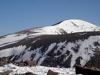
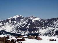
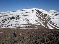
Paul Benchmark and Bluebell Pass Peak, Uintas, Utah

Paul Benchmark and Bluebell Pass Peak, Uintas, Utah

Page Type Page Type: Trip Report
Location Lat/Lon: 40.68193°N / 110.39348°W
Date Date Climbed/Hiked: May 17, 2008
Activities Activities: Hiking
Seasons Season: Spring

Overview

Paul Benchmark (12307)Paul Benchmark (12307)

What:One day hike/snowshoe trip to the summits of 11611, 11656, Paul Benchmark (12307) and Bluebell Pass Peak (12036)
Where:Uinta Mountains, Utah, 5.15 miles SW of Mount Emmons
Length:21.6 miles round trip
Elevation gain:5725 feet
Start location:Swift Creek Trailhead
Date:May 17, 2008
Round trip time:15 hours 15 minutes, 5:25am to 8:40pm
Time to furthest summit:8 hours and 13 minutes
Participants:MOCKBA and myself

The Trip


Mount Emmons and South Mount EmmonsMount Emmons and South Mount Emmons
Wilson PeakWilson Peak
Topo of trip to Paul and Bluebell Pass PeakTopo map of trip
My current hiking goal is to climb as many obscure 12000' peaks in Utah as possible. There are many in the Uintas that no one ever seems to go to or is even aware of. Does the name Paul ring a bell? How about Val or Stone? Scott has a list of the 115-118 (depending upon how you count) Utah 12000 footers with 200 feet of prominence. After a ski tour to Coffin Peak in April I was looking for another 12000 footer that I could bag this time of year. I thought that the trailheads would still be snowed in, but my ski friends MOCKBA, Rob, and Mike relayed that the Swift Creek Trailhead was accessible by car as of May 4. They had done an exploratory ski tour and headed up the Swift Creek drainage in the general direction of Paul (12307). I got out my maps and noticed the nice gentle ridge running south of Paul, 5.15 miles south west of Mount Emmons and 7.4 miles southeast of Wilson Peak. In addition, there was another 12000 footer, Bluebell Pass Peak (12036), 1.5 miles north of Paul. Both of these seemed ripe for bagging. The only problem was that they were a long way from the trailhead. I mapped out a route and Bluebell Pass Peak was over 9 miles away with a 5500' total elevation gain. To simply come back the same way would be another 1400' of gain. It sounded like a big day, a technically easy but strenuous trip. Alternatively I could go all the way to Bluebell Pass and descend to the east via the Swifts Creek drainage, virtually downhill all the way back, but still a long 18 miles round trip through completely unfamiliar territory.

I sent email out to everyone I knew who might be interested. I got several no's and one offer to go on a trip at a later date. So, I planned to go by myself leaving Thursday May 15. MOCKBA hadn't responded at all and I thought this was a little odd since he had previously expressed some interest. Finally I got some email from him the day before that didn't quite make sense. But after several email exchanges it became apparent that we were in disagreement about what the phrase "within the next week" meant. There was further confusion about when his conflicts were since we were each talking about different weekends, but we finally figured things out and agreed to leave Friday May 16 and hike the following day.

We set out late Friday afternoon from Salt Lake City headed for the Swift Creek Trailhead and campground. Instead of driving the quickest way to Duchesne along route 40, we opted to take route 35 through Wolf Creek Pass, which had just opened up for the season the day before, so that MOCKBA could check out the terrain for a future ski tour. As we got close to the trailhead, we also checked out forest roads 271 and 196 leading to Center Park, also for a future ski trip. Every time we crunched over a big rock or a downed tree branch I couldn't help but remember how he had mentioned earlier that his spare tire was flat.

The snow had melted completely off of the dirt roads and they were well signed all the way to the Trailhead at the Swift Creek Campground. The campground was completely free of snow at 8100' and the water had already been turned on.

Open forest on the way to PaulOpen forest on the way to Paul
Paul looming aheadPaul looming ahead
To get an early start to beat the heat, we were on the trail up the Swift Creek drainage at 5:25 am. This trail starts by climbing the very south end of the south ridge of Paul. When the trail left the ridge after climbing to about 9120', we turned north off of the trail to continue along the ridge. Driving up the night before and getting a view of the south end of this ridge had me a little worried. I had pictured it still in snow covering up all of the brush, but the snow was completely melted off and it appeared quite thick with trees. But, not to worry, it was fairly easy bushwhacking all the way to treeline. The first rays of sun reached us at 6:45 on a small rocky knoll at 9760'.

Soon we began to encounter soft intermittent snow patches. At about 10500' there was mostly snow and by this time it was firm enough to walk on without sinking through. Treeline was reached about 10700'. Somewhere along the way MOCKBA realized he had lost his sunglasses out of an unzippered jacket pocket. I checked all of his pockets too and sure enough no sunglasses. What a blow. The sun hadn't been too strong up to now since we had been in the trees and it was still early. However, it was about to be blazing down on us and reflected back by the snow. When we broke out of the trees I lent him my brimmed hat. My sunglasses were prescription so we couldn't time share them.

MOCKBA heading down rocky bare north side of 11611MOCKBA heading down rocky bare north side of 11611
Me on the side of 11656Me on the side of 11656

On the way to our first peak (11611) we made a point to stop at N40 38.823 W110 22.992 where there was supposed to be a temporary benchmark LO1049. We looked around awhile and MOCKBA finally spotted a metal bar sticking up and we assumed that that was it. We continued up the snowy south side of 11611 and upon reaching the summit were surprised to find that the north slope was bare. The same thing would hold for 11656 and Paul as well. The south sides of these slopes had snow while the north sides were bare. Go figure. We speculated that the north sides must get more wind and the snow there is blown off, but who knows. I had anticipated cruising down the north sides of all of these slopes on consolidated snow, but instead we had to pick our way carefully down seas of boulders.

We continued on our way to the saddle before 11656 and began our ascent. I had had one major worry about this hike and that was the high predicted temperatures. The area in which we'd be hiking would see lows in the 30's and highs in the 60's. A high low meant there wouldn't be a good refreeze resulting in a day long slog through mushy snow. A high high meant that even if there was a refreeze it wouldn't last very long. We now encountered the feared mush on our way up and put the snowshoes on. But, even with the snowshoes we would occasionally posthole up to our knees. The top of 11656 was bare as were the other three summits we would reach today.
View NW from Point 11,611View NW from 11611


Yet another use for duct tapeYet another use for duct tape
We headed down the other side of 11656, took our snowshoes off when we hit the rocks, and had a nice break at the base of Paul. The weather could only be described as pleasant. Nice and warm but not too hot and only a mild breeze. We discussed options to MOCKBA's sunglasses problem and hit upon a plan to do something similar to what our distant ancestors must have done. MOCKBA MacGyvered up a pair of glasses from a "Mrs. May's Fruit and Nut Crunch" bag. He cut the bag into a face size rectangle, cut little holes to see out of, and attached it around his head using duct tape and the lanyard from his GPS. The contraption was a little greasy and far from perfect but it was better than nothing. Hopefully it would do the trick. The down side was that he could see straight ahead, but not down. We debated the merits of proceeding up some bare rocks on the side of Paul compared to heading up a more direct but snowy route to the summit, worrying that the snow would be mushy. The rocks were advantageous because they wouldn't reflect light but they'd be easy for MOCKBA to trip over. After he tripped in the first 10 steps I suggested we try the snow. I was glad we did because the first 500 vertical feet were dream snow. Perfectly consolidated but just the right amount of softness so your boot could grip well. The second 500 vertical feet weren't quite as good as we occasionally postholed but they were still great compared to the snow on 11656.

MOCKBA approaching PaulMOCKBA approaching Paul
We made it up Paul and MOCKBA found the benchmark a little south of the perceived high point. All along the ridge we had fantastic views, the Kings-Emmons ridge to the northeast and Wilson to the northwest. I had the feeling that we were the only people for miles around and we probably were. The Uintas didn't seem very popular at this time of the year. We descended Paul and crossed the small 12099 bump to the saddle below 12036. We had another nice long break lounging in the warm sunshine and still air and discussed by what route we would return to the car after climbing 12036. The first was simply to go back the way we came. I wasn't looking forward to picking my way across any more rocks and even more so didn't want to have to climb all of those summits again. The other descent option I had thought of when planning this trip was to go over 12036 to Bluebell pass and descend via the Swift Creek drainage to our east. After a short initial steep descent it would be about another 8 miles of gently sloping terrain and seemed the most logical choice. I hadn't even considered a route to the west since I remembered the trail on that side being described as wet and miserable going. Well, MOCKBA is an exploring kind of guy and although he had been on the Swift Creek side several times had never ventured on the Yellowstone Creek Trail to the west. I questioned the wisdom of proceeding down a "wet" trail in the height of spring runoff and could only imagine the worst. But it was clear that was what he wanted to do and I decided I should be a little flexible and agreed to go that way. One problem was that since I hadn't anticipated this route I didn't have any waypoints plotted for it and didn't have a map for it. The only map MOCKBA had was a teeny reduced piece of the 1:100000 series map that if I took off my glasses and squinted real hard could barely make out, so it was tough to tell exactly what I was agreeing to.
View northeast from PaulView northeast from Paul

View west from PaulView west from Paul


MOCKBA heading toward Bluebell Pass Peak (12036)MOCKBA heading to Bluebell Pass Peak (12036)

It was just another 240 feet up to our final summit of the day, Bluebell Pass Peak (12036), which we reached a little past 1:30, about 8 hours and 15 minutes after we had started. At the top we discussed continuing further along the ridge to the summit past Bluebell Pass but I was adamant that I had had enough. I heard no complaints from MOCKBA. So our plan was to head west across the summit plateau of 12036 bypassing its wicked looking south side cornice and then head southeast to a gully that we would follow down to the trail. The initial 600 feet of descent to the base of 12036 were bearably mushy and we were able to glissade part way down. However, when we hit bottom at 11400' the snow became miserably mushy and we quickly put on our snowshoes. Unfortunately, we still were doing some bad postholing and the going was slow. This was beyond simple trailbreaking as the snow would collapse underneath with every step, but at least we were only sinking in to our knees and not our butts. After awhile it wasn't quite as bad but it was still bad. MOCKBA led 99.99% of the way and I found that in areas where he was sinking through if I put all of my weight on both poles and stepped gingerly I at least had a chance of not falling in too. If my snowshoe did break through sometimes it was quite hard to get it back out requiring some excavation of snow with my hands. I wasn't happy at all. I wasn't even convinced we were going in the right direction. But MOCKBA had never failed me yet at getting us someplace and he wasn't about to start now. Finally, we hit some bare patches and took our snowshoes off and reached the Yellowstone Creek Trail at about 9600'. We almost missed the trail. MOCKBA crossed right over it without stopping. It was hard to make out in all the snow but I recognized it because there were a few snow-free spots that were completely bare of any vegetation. It would have been a sad day indeed if we had missed the trail and gotten to the swollen, raging creek not knowing for sure which side of the creek the trail was supposed to be on.

MOCKBA descending Bluebell Pass Peak (12036)MOCKBA descending 12036


Glissading from South BluebellMe glissading down 12036


Finally a bare spotFinally a bare spot


The trail started out as mostly snow patches but quickly turned to mostly bare patches and was eventually completely bare. We soon passed a sign that said it was 10 miles back to the campground. Groan! It was past 4pm by that point. I kept anticipating the much dreaded wet sections of the trail but by some luck and magic they never materialized. We encountered nothing that one wouldn't expect along any trail this time of year, and found the trail quite delightful with several scenic views of the creek. We speculated that the trail had undergone a major reroute as when MOCKBA returned home he consulted his hiking guide which cautioned against "3 fords" of the creek and said the trail was "impassable in spring"! I could not imagine crossing that creek and surviving to tell the tale. The down side was that there were several short uphill sections along the way and I cringed at each and every one.

We went a couple of miles and stopped for a long break. MOCKBA had a small fire going in about 5 seconds and in another 5 was cooking kielbasa on one stick and toasting a bun on another. After I ate mine I took the opportunity to lie down and enjoy the warm sunshine. Too soon it was time to go and we began the remaining 8 mile trudge back to the car. We reached the car about 8:40pm, 15 hours and 15 minutes after we had started. It had been a long but very pleasant day.

In retrospect, coming down the Yellowstone drainage was a fine idea as far as the trail conditions went. However, it added an extra 3 miles to the trip over the Swift Creek side, resulting in 21.6 miles round trip. Also, I suspect that the off-trail section on the Swift Creek side would have been easier to navigate, but, who knows?

MOCKBA's sunglasses contraption must have done the trick because the next day he said that his eyes were fine. I was a little sore but not too bad and hope to return to the Uintas soon to climb some other 12000 footers that nobody's ever heard of.

Yellowstone Creek TrailYellowstone Creek Trail


Yellowstone CreekYellowstone Creek


Almost back to the carAlmost back to the car


Participants


MOCKBAMOCKBA


MeMe


Comments

Post a Comment
Viewing: 1-2 of 2
mtn runr

mtn runr - May 23, 2008 5:10 pm - Voted 10/10

High adventure

in the High Uintas! Great trip Report, Judy! I am green with envy! Actually it's probably good I wasn't there: I can't do 15-hour trips any more and still be smiling at the car.

ZeeJay

ZeeJay - May 23, 2008 7:28 pm - Hasn't voted

Re: High adventure

I was definitely smiling at the car, less smiling before the car.

Viewing: 1-2 of 2