To Red Pine Lake
WE ARE A CLIMBING TEAM BASED IN UTAH. FOR MORE INFORMATION GO TO OUR TEAM WEBSITE: www.oldriversclimbing.com
While gazing up into the peaks towering over the Salt Lake Valley, it may sometimes seem a formidable task just getting close enough to bag some of them. The Pfeifferhorn is one of these peaks. When looking from the right angle, it is possible to see this prestigious peak (resembling a sharks tooth) from downtown Salt Lake City; however, only the very top is visible. All I knew is that I wanted to stand on the top of it, regardless of the journey that it would take to get there,
I wanted to team up with someone sharing my vision, and asked my neighbor Jamison if he would like to go. He had already climbed many of the peaks in the Wasatch Range, but coincidently had yet to do the Pfeifferhorn. We made some plans, and set off on the evening of July 3rd to begin our trek.
Temperatures were holding in the mid 90s as we made our way to the entrance of Little Cottonwood Canyon, and we were glad to see the mercury drop about 10 degrees as we reached the White Pine trail parking lot. We made some last minute adjustments to our packs, and started heading up the trail.
From the parking lot the trail dips down and sharply to the left, crosses over a large stream, and then starts heading West parallel to the road. You will cross through an open area where trees have been mangled and knocked down by recent avalanches, and as we crossed it, we looked forward to getting back to the wooded area and into some cover from the sun.
The grade is not steep, but you can see quick gains in elevation as the road up the canyon gets further and further below you. At one point there is an opening in the trees along the right-hand side of the trail, and there is a spectacular view looking right down the middle of Little Cotton Wood Canyon and into the Salt Lake Valley.
After a mile, you will reach another stream, and the trail that you are on turns left and starts heading up the White Pine Canyon. There is also a small dirt path off the left-hand side of the trail before the stream that looks insignificant, but it is the correct trail to head up towards Red Pine Lake and eventually the Pfeifferhorn. (I know numerous people that assume that this is not the trail, and have ended up going into White Pine Canyon by accident.)
We enjoyed a brief rest at the stream, then continued up the trail towards the lake.
At this point the grade starts getting steeper, and there are a number of sections that are pretty draining. At some points the trail turns into what looks like an old stream bed, and at times there is some water and mud that you will have to traverse. The trail goes through some meadows just before reaching the lake, and we encountered a number of deer feeding on the lush green grass blanketing the hillside. They would stop and look at us as they chewed, and hardly seemed intimidated by our presence. Considering the healthy mountain lion population in this area, I am sure that we were the least of their concerns.
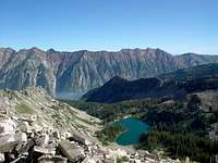
[ Nonetheless, the trail is very scenic, and in just under two hours we made our way up the last push and arrived at lake.
We followed the trail around the East side of the lake to where a stream drains into it. We didn’t like the prospect of camping where we couldn’t hear if anything was coming close to our tent, so we relocated to the Northern side of the lake and found a suitable campsite.
We had some uninvited guests at our site and we consequently broke out some bug repellant in order to take care of them. We set up our tent and pumped some water from the stream that drains out of the Northwestern corner and heads down towards the trail we had just come from.
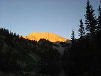
While we cooked dinner we enjoyed the changing scenery as the setting sun lit up White Baldy to the Southeast.
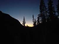
I admired the show, took a mental note adding it to my to-do list, then checked to make sure that we hadn’t torched our dinner. We were joined by a few other campers, but for the most part we had the lake to ourselves. As it got dark we sat out looking for satellites and other heavenly objects passing overhead, and then decided to call it a night so we could get an early start in the morning.
To the Top
We got up around 6AM – and went through the tiring but necessary ritual of pumping water. We were mostly just ecstatic that we had survived the night unmolested from bear attacks. (This hike took place about the same time that a sleeping camper was ripped from his tent and sadly killed by a bear in a campsite not too far away.) We both pounded some banana bread, and began our journey around the lake and onto the trail. I noticed some deer tracks along the path parallel to the lake that had not been there the previous evening, and it made me contemplate the amount of animal activity that takes place up there during the night.
After passing the lake, the trail starts gaining elevation and weaving through a small pine forest. Make sure to follow the majority of footprints as there are many different routes to get to the saddle, all with varying degrees of difficulty. We had to stop a few times and regain the main trail which was timely, but worth it. The primary trail follows pine trees up a steep ridge, and if you find yourself out in the open then you have taken one of the lesser-traveled routes.
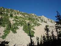
The trail eventually breaks out into the open as you begin the steep climb to the saddle, and at this point you will be able to see the dominant dirt path that works its way upwards to the top. As we negotiated the rocky slope, we could hear the high-pitched chirping coming from in and around the rocks. We were definitely in Marmot country. We could see them scampering through the boulders on the hunt for something to eat, and enjoyed the company considering we had not seen any fellow hikers up to this point.
This part of the trip is probably the most tiring as it does not flatten out until reaching the saddle. It is fairly steep and consistent, and laden with rocks and small boulders. Follow the path to the top, and while resting turn around and enjoy the view of the lake and smaller ponds at the base of white baldy. After reaching the saddle you will catch your first glimpse of the Pfeifferhorn, along with an unobstructed view down into Utah County.
To the South you can see Box Elder Peak and Mt. Timpanogos in the distance, and various other peaks to the West and North.
We stopped to take pictures, drink some water, and plan our assault to the top. Some of the flattest and easiest trail on the whole trip can be found from the top of the saddle over to the boulder ridge. It is mostly dirt, with no rocks, and just meanders along the top of the ridge to the boulder field. Enjoy it while you can, because the class 3 section is coming up quickly.
The ridge looks intimidating from the trail, but once you get started it will not seem as bad.
I have done it a few times, and I think the best way to cross it is to work along the right and top sides of it. We would cover some ground on the right hand side and reach a shady section, then work our way back on top and find an easier route from there. There are a few tricky moves, but nothing that requires climbing gear or rope.
After crossing the ridge it is simply a matter of endurance to get to the top. The last 300 feet to the top looks to steep to climb from a distance, but once you are there it is not bad at all. We worked our way up the trail and soon found ourselves at the top.
The summit is not very pronounced, just a somewhat-flat top with some rocks and boulders covering it. We could see some hikers picking their way along the ridge below us, and some more that had just reached the top of the saddle. We had been the first ones to make it to the summit that morning, and we couldn’t think of a better way to bring in the 4th of July.
To the Bottom
We worked our way back down to the saddle, and negotiated the steep rocky ledges down to the lake. We passed a good number of hikers coming up the trail, and tried to raise their spirits by sharing the news of our successful summit attempt. From the saddle we looked down into Little Cottonwood Canyon and noticed a whitish haze building up. We hoped it was not smog from the valley, and later learned that there was a forest fire burning not too far away.
We packed up our gear at camp, strapped on our packs, and began the descent down to the road. It was a gorgeous day, and we passed a number of people heading up to the lake for a 4th of July picnic. It was ironic that we were heading down the trail to meet up with our families to do the same.


Comments
Post a Comment