Loosening the Reins of Discipline
I am usually too disciplined for my own good. I do make efforts to correct this condition from time to time. The fruit of my last effort was a glorious day in the Mt. San Jacinto State Park Wilderness Area last Wednesday. I decided to play hooky from work just the day before. I commandeered my youngest son, Daniel, and one of his close buddies, Ian, to join me in hiking to San Jacinto Peak from the upper Palm Springs Tram station. We anticipated beautiful weather and few other hikers out there during the middle of the week. We were right on both counts.
I wanted to get an early tram up so I got everybody up by 5:30 a.m. and we got to the tram by 7:45 a.m. Again, part of my disciplinary trait. Bad news. During the week, the tram doesn’t start rolling until 10. I apologized to my son and his friend for depriving them of two hours of sleep by not checking the tram web site. We waited while the temperature soared to near 90 degrees F. by the time the first tram left at 10 a.m.
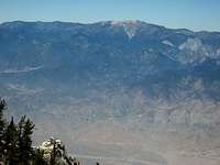
However, at the 8,516 foot elevation upper tram station, the temperature was a pleasant 69 degrees. We flew down the circular ramp and over to the Long Valley Ranger Station to get our self-issued permit. Then on the trail to Round Valley and then Wellman Divide.
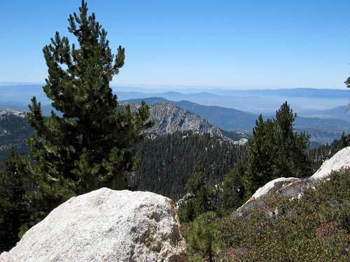
![View SW from Wellman Divide]() View SW from Wellman Divide
View SW from Wellman DividePine Scent on the Trail
Past Wellman Divide a soothing breeze carrying the wonderful scent of pine came along. This type of breeze, with this scent, is one of my favorite sensations in the mountains.
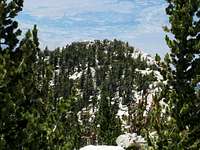
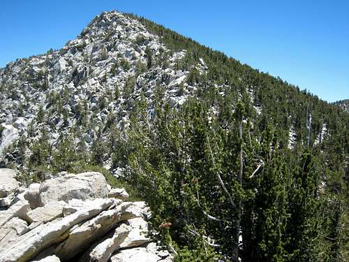
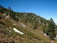
I especially always enjoy the part of the trail to San Jacinto Peak past Wellman Divide. You look east back down at the upper tram station. Cornell Peak thrusts its triangular form into the sky to the northeast. Jean Peak is to your left up to the point where the trail makes that U-turn right at the foot of Miller Peak.
![Cornell Peak (9,750 ) from Trail to San Jacinto Pk]() Cornell Peak (9,750') from trail to San Jacinto Peak
Cornell Peak (9,750') from trail to San Jacinto Peak![Jean Peak (10,670 ) from Trail to San Jacinto Pk]() Jean Peak (10,670') from trail to San Jacinto Peak
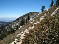
Jean Peak (10,670') from trail to San Jacinto Peak![Along Trail to San Jacinto Peak]() The trail to San Jacinto Peak past Wellman Divide
The trail to San Jacinto Peak past Wellman Divide
Before you know it, you’re right underneath the summit. We stopped in at the stone cabin to sign the peak register and then finished the scramble to the fading wooden sign that proclaims that you are at 10,834 feet above sea level. We had lunch on the summit.
![Sign below summit of San Jacinto Pk (Calif.) -NOT FOR VOTING]() Sign .3 miles below San Jacinto Peak
Sign .3 miles below San Jacinto Peak![Jean Peak (10,670 ) from summit of San Jacinto Pk (10,834 )]() Jean Peak (10,670') from summit of San Jacinto Peak (10,804')
Jean Peak (10,670') from summit of San Jacinto Peak (10,804')Discovering Folly Peak
While looking at my topo map, I noticed what on the map looked like an easy jaunt to something called “Folly Peak,” northwest of San Jacinto Peak. I took a compass bearing and confirmed where Folly Peak was from our position. From an eye-ball perspective, Folly Peak looked a lot further away than it looks on the topo.
![Looking toward Folly Pk (10,480 ) along San Jacinto Pk s NW Ridge]() Folly Peak (10,480') from summit of San Jacinto Peak
Folly Peak (10,480') from summit of San Jacinto Peak
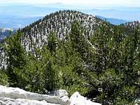
The route to Folly involved a 300-foot drop along a ridge of rock and trees. We threaded our way through the trees down to a small saddle, up to a false summit, a second false summit, a second small saddle, and then it was a short scramble to Folly’s summit from there. Its elevation was not marked on my topo. I later learned from the SP page that Folly’s elevation is 10,480 feet. This peak had great views especially to the north looking across Interstate 10 to the vast mountain range that rises dramatically from the valley bottom, including Mt. San Gorgonio (11,499’). Looking back towards the top of San Jacinto Peak, we traced the ridgeline we had come down. The route looks harder than it actually is.
![View North from Folly Pk (10,480 ), San Jacinto Wilderness]() View north from Folly Peak
View north from Folly Peak![View towards San Jacinto Pk from near Folly Peak]() Looking back at ridge route from San Jacinto summit to Folly Peak
Looking back at ridge route from San Jacinto summit to Folly Peak
We returned up the ridge to San Jacinto Peak. The round trip had only been 25 minutes. I thought of trying to talk the boys into heading over to Jean Peak, but subtle indications were that they were ready to head back.
Miller Peak: Easiest 10,000 Foot Peak to be Had
As with Folly Peak, I had noticed on my topo something called Miller Peak immediately northeast of where the trail makes a sharp north/south U-turn. I convinced the boys that calling on Miller Peak would be an easy matter on our return. And indeed it was. Miller Peak has to be the easiest 10,000 foot peak (10,400’ to be precise) to ascend from a trail.
We stepped off the trail at the U-turn and soon came upon a large flat area. The obvious high point, a rock summit, was on our right and we headed there. The summit has two plaques attached to the rock, one reciting the Boy Scout Oath and the other a tribute to Mr. Miller after whom the peak is named.
![Miller Peak (10,400 ) from trail to San Jacinto Pk]() Miller Peak (10,400') from trail to San Jacinto Peak
Miller Peak (10,400') from trail to San Jacinto Peak ![San Jacinto Pk (10,834 ) from summit of Miller Pk (10,400 )]() San Jacinto Peak (10,834') from summit of Miller Peak (10,400')
San Jacinto Peak (10,834') from summit of Miller Peak (10,400')
After our third 10,000 foot peak of the day, we returned to the tram and took the awesome ride back down into the desert heat. We’d had a great day-done about 13 miles with 2600-2700 feet of gain- and GUESS WHAT? Business had survived back at the office very well without me.


Comments
Post a Comment